

Jan 21: Coastal Storm Update
The prime impact window for this event is narrowing down to late Sunday night-early Tuesday AM. Let’s break it down…
Disco: The upper-levels continue to strongly support a strong 250mb jet pattern enhancing and interacting with a cut-off 500mb low which ultimately controls a strong surface low moving through our region. It will actually be a very impressive mid-latitude cyclone which we’ll see on satellite observations in the middle of it.
I’m not enthused on winter precipitation for New Jersey. Someone is going to get snow-smacked further to the N/W (PA elevations into upstate NY maybe). The only NJ area that could potentially see wintry precipitation mixed into the rain would be NWNJ. The storm would have to over-perform on the colder side for that to happen. It’s possible but nothing is currently screaming this.
Expected rainfall, averaged out over all model guidance, is about 1-3 inches statewide. It is certainly possible that localized rain totals could exceed this range given the low strength and moisture tap. Convective banding is on the table. Let’s stick with 1-3 generally for now.
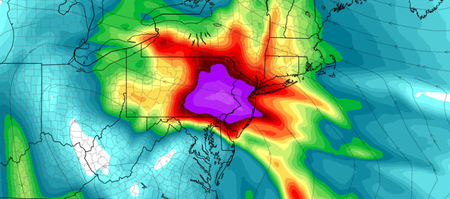
Expected sustained winds are in the 25-35mph range statewide with gusts capable of exceeding 50mph. Therefore all areas are subject to power outages that typically result from falling branches and downed-wires. A 60-70kt 850mb jet (pictured above) has been strongly modeled during the worst of the storm. Obviously the surface will not be as strong but some of that wind energy could be brought down for a few surprising gusts at the surface. It’s a good time to secure loose things outside.
The latest tidal guidance is suggesting storm tides (tide + surge) of 6-7 feet above MLLW from Cape May to Sandy Hook. The Raritan and Lower Bays are modeled at 7-8 feet above MLLW. The western-most part of the Long Island Sound (near Brooklyn and Queens) is currently modeled for a 8-10 foot storm tide. So in general, the storm tide gets worse as you head up the Jersey coast towards NYC/Long Island/CT. There are 3-4 high tides of concern between Sunday night and Tuesday morning. Back bays are most susceptible to storm surge flooding when inlets align with onshore flow. With all of this said, the Delaware Bay and SNJ coast (up to about AC) should expect at least minor coastal flooding. AC/LBI and coastal points north are looking at possible moderate coastal flooding.
In English: Expect rain and wind from late Sunday night through at least Monday night, possibly early Tuesday AM. Most would call this a nor’easter. During this period, sustained winds could range from 25-35mph with gusts up to 50-60mph. Power outages are anticipated. Coastal areas should expect minor-to-moderate flooding and beach erosion. While this is not a snow storm and therefore will have very little public interest, it will be a very powerful storm for the coast with impressive atmospheric dynamics at all levels. Now-casting begins tomorrow. Be safe! JC
Jonathan Carr (JC) is the founder and sole operator of Weather NJ, New Jersey’s largest independent weather reporting agency. Since 2010, Jonathan has provided weather safety discussion and forecasting services for New Jersey and surrounding areas through the web and social media. Originally branded as Severe NJ Weather (before 2014), Weather NJ is proud to bring you accurate and responsible forecast discussion ahead of high-stakes weather scenarios that impact this great garden state of ours. All Weather. All New Jersey.™ Be safe! JC


LOCAL FORECAST | INTERACTIVE RADAR | LATEST NJ WEATHER ALERTS | WEDDING FORECAST| PRIVACY POLICY
© Copyright 2026 Weather NJ LLC. All Rights Reserved.
Some information that can be found on our website is provided by a private weather station and is not an officially recognized station for weather reporting. Though we always strive to achieve accurate reporting for our own use, it is important that you do NOT depend on the data provided here for any purpose.
