

Jan 21: Weekend System looks Warm for Most
Discussion: The strong area of high pressure responsible for the cold this week will ultimately be responsible for the moderation in temperature between Thursday and Saturday night. The front side of the high’s anti-cyclonic flow brought cold from the N and the back side (once it tracks E of NJ longitude) will bring warmer temperatures up from the S behind it. Thursday-Saturday is a transient moderation as temperatures are expected to return to the overall prolonged cold pattern Sunday into next week. This Thursday-Saturday period however also coincides with weather system expected to impact NJ with precipitation Saturday into Sunday.
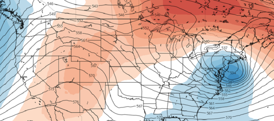
We’re dealing with an upper-level low that will be trapped between a split-flow pattern. The jets will ultimately guide this ULL eastward over the Mid-Atlantic US but it should track very abnormally while doing so. A surface low will form in relation to the ULL which will ultimately bring us our disturbance.
The NJ surface temperature profile looks very marginal throughout this system meaning slightly-above freezing for most areas. Currently I only see wintry concern for extreme NNJ (N of I-80/NW of I-287). Sussex County is favored as ground zero wintry-wise. The rest of NJ (S of I-80/SE of I-287) is likely looking at a cold rain with temperatures in the mid-to-upper 30s even lower-40s. With that said some of the model guidance is suggesting double-digit accumulations for Sussex County especially the higher elevation microclimate which behaves more like the Poconos and Catskills.
Given the uncertainty of the exact ULL track it is very hard to pin down expected wintry accumulations for NNJ. I imagine the model guidance will change many times between now and Saturday. It might bring more of NJ into the snow (maybe down to I-78). It might bring less. We likely won’t have wintry-impact maps out until Thursday. But for the rest of NJ (NENJ, all of CNJ and SNJ) this system seems too warm for a snowstorm. I’ll check back each day and report on the extreme NNJ wintry expectations.
In English: Temperatures should moderate milder Thursday-Saturday. A system should then float through from W to E between Saturday and Sunday bringing rain to most of NJ but possibly snow accumulations to NNJ (especially NWNJ). I’ll also be monitoring any coastal flooding aspects that may impact ECNJ/SENJ via prolonged onshore flow. We’ll have a much better handle on this by Thursday but for now just know that the weekend does not look dry and clear. Have a great Tuesday night and please be safe! JC
Download the new free Weather NJ mobile app on Apple and/or Android. It’s the easiest way to never miss Weather NJ content. Our premium services go even further above and beyond at the hyper-local level. Looking for industrial-caliber long-range forecasting data that I personally recommend? Check out WeatherTrends360! Visit the Weather NJ Kaboom Shop for hoodies, tees and infant onesies.
Jonathan Carr (JC) is the founder and sole operator of Weather NJ, New Jersey’s largest independent weather reporting agency. Since 2010, Jonathan has provided weather safety discussion and forecasting services for New Jersey and surrounding areas through the web and social media. Originally branded as Severe NJ Weather (before 2014), Weather NJ is proud to bring you accurate and responsible forecast discussion ahead of high-stakes weather scenarios that impact this great garden state of ours. All Weather. All New Jersey.™ Be safe! JC


LOCAL FORECAST | INTERACTIVE RADAR | LATEST NJ WEATHER ALERTS | WEDDING FORECAST| PRIVACY POLICY
© Copyright 2026 Weather NJ LLC. All Rights Reserved.
Some information that can be found on our website is provided by a private weather station and is not an officially recognized station for weather reporting. Though we always strive to achieve accurate reporting for our own use, it is important that you do NOT depend on the data provided here for any purpose.
