

Jan 21: Weekend Winter Storm Update
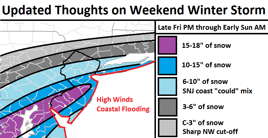
The latest model guidance as well as live observations of the system’s maturity to our SW are leading towards a colder solution for southern areas and less accumulations for points north. I have adjusted my map accordingly.
The red line is my greatest concern. It represents where coastal flooding should occur from a combination of a near-full moon and large wind field around the low pressure system. Isobars will be parallel and tight so winds should gust between 40-60mph. Once winds shift from NE to N/NE, the coastal flooding aspect should be reduced. Until then, use extreme caution for said areas.
The light gray area represents the hardest call of this forecast. Given the high pressure and dry air to our north, there will be a sharp cut-off in precipitation. This means that 10-20 miles north or south can mean the difference in light to significant accumulations.
The dark gray area should represent the extent of the heavier snow leading to significant accumulations.
The light blue area is broken into two locations. The NW area should be all snow with significant accumulations. The SE area along the coast is subject to a short period of mixing. Because all guidance has trended colder, the mixing is less of a concern but not completely off the table, especially during the easterly wind component of the storm.
The dark blue area represents heavy accumulations of snow. This zone is potentially Kaboomable. The only caveat is for the ocean county coast which could see a very short period of mixing. As with the lighter blue area, this is less of a concern with the colder trending solution but not completely off the table.
The purple area represents the jackpot zone. This is potentially the most Kaboomable zone of the snow storm. If “dude, where’s my car?” is going to happen, it will most likely be here.

Storm Synopsis:
A powerful synoptic winter storm system will have full control of the region this weekend. Friday will be a day of anticipation as the system matures to our SW and scoops up Gulf of Mexico moisture. The upper levels of this setup looks healthy with a fully closed off low at 500mb well in-advance of New Jersey arrival. The surface energy will stack neatly beneath the upper level low and allow the system to drop to about ~984mb of intensity after ejecting into the Atlantic Ocean somewhere over the Outer Banks of North Carolina. The low will head towards the benchmark (40N/-70W) but transfer east before reaching such. This is why most of New England is expected to see little to no snowfall.
There should be 3 phases of this storm:
The first phase is the initial “overrunning precipitation” which is the Gulf of Mexico moisture colliding into colder air mass over New Jersey. During this phase, I don’t expect the winds to be too bad but it should start as snow. This phase is looking like late Friday night into early Saturday morning.
The second phase is when the low is directly to our south (over OBX). This is when the easterly winds will pick up off the ocean and begin the moderate-to-high coastal flooding risk. This could possibly change snow over to an icy mix or even rain for a period along the coast. With the latest trends that period is shrinking.
The latest marine guidance is suggesting a storm surge of 3-4 feet which could contribute to a total water guidance of 7-9 feet above mean surface level. This coastal flooding threat will persist until the low positions itself towards our east. At that point, winds should shift from E to NE and ultimately the N/NE. So as soon as the winds shift from NE to N/NE, the flooding threat relative to any wind-field off the ocean should subside. It is also important to note that Sunday is a full moon which could present a slightly more elevated peak high tide. There are 3 high tides of main concern between Saturday morning and Sunday morning and those will be my greatest periods of concern for coastal flooding. This second phase should occur between Saturday morning and early Saturday evening.
The third phase of the system will be when winds switch to the N/NE and ultimately N. This is when the best snow ratios should occur as the system pulls away with us in the coldest part of the precipitation shield. This third and final phase should occur between early Saturday evening and Sunday morning.
In English: A major winter storm will impact New Jersey and surrounding areas between late Friday night (should start between 9PM and midnight) and early Sunday morning (ends by noon). This obviously places all of Saturday in the expected storm window of time. Expect heavy snow with the greatest accumulations in CNJ/SNJ. Expect high winds, especially along the coast. Expect moderate-to-high risk coastal flooding, especially along the SENJ coast. My final snow map and forecast for this system will be issued tomorrow but this is where I’m at right now. Be safe! JC
Jonathan Carr (JC) is the founder and sole operator of Weather NJ, New Jersey’s largest independent weather reporting agency. Since 2010, Jonathan has provided weather safety discussion and forecasting services for New Jersey and surrounding areas through the web and social media. Originally branded as Severe NJ Weather (before 2014), Weather NJ is proud to bring you accurate and responsible forecast discussion ahead of high-stakes weather scenarios that impact this great garden state of ours. All Weather. All New Jersey.™ Be safe! JC


LOCAL FORECAST | INTERACTIVE RADAR | LATEST NJ WEATHER ALERTS | WEDDING FORECAST| PRIVACY POLICY
© Copyright 2026 Weather NJ LLC. All Rights Reserved.
Some information that can be found on our website is provided by a private weather station and is not an officially recognized station for weather reporting. Though we always strive to achieve accurate reporting for our own use, it is important that you do NOT depend on the data provided here for any purpose.
