

Jan 22: Coastal Storm Approaching!

This will be the last predictive article heading into this event. All posts from this point forward will focus on live observations.
We have 4 components of this system that we’re watching closely: Wintry precipitation, rain, wind and coastal flooding. Eastern PA Weather Authority and Weather NJ have collaborated on the following expectations:
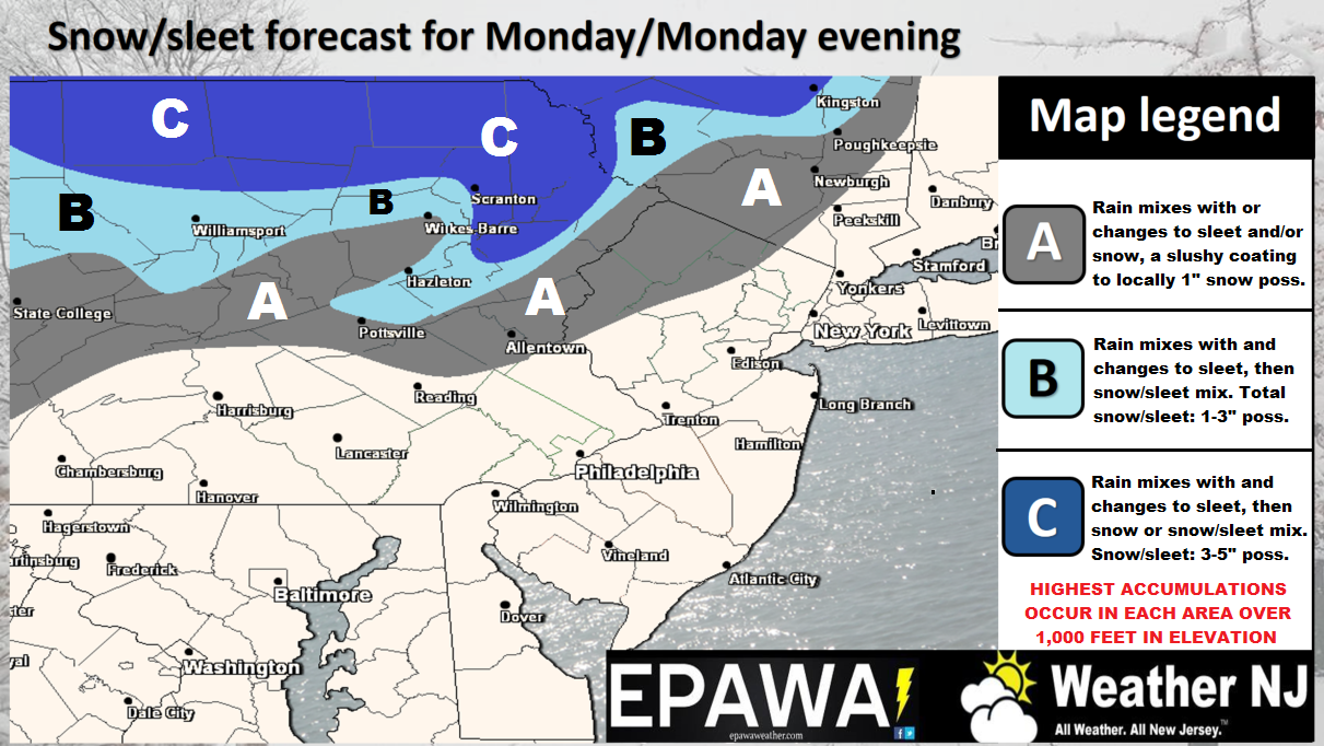
Click here for full resolution snow map.
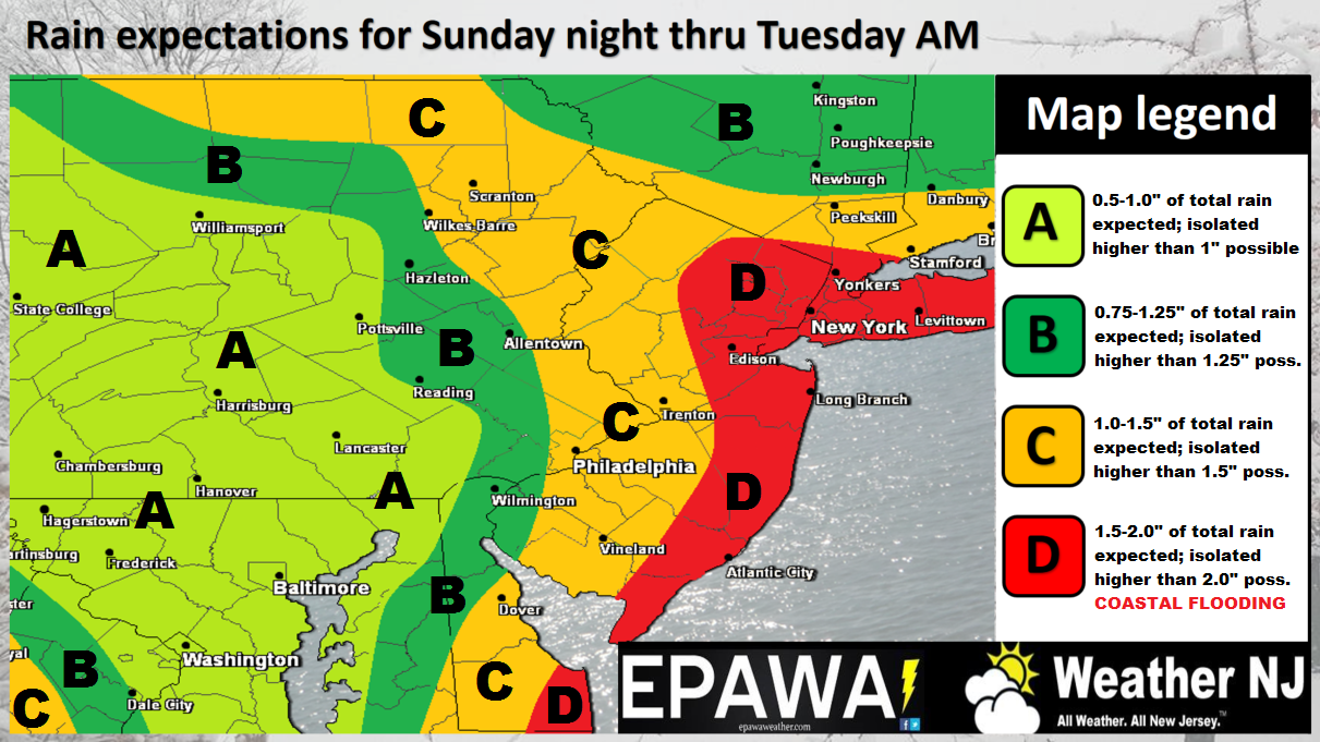
Click here for full resolution rain map.
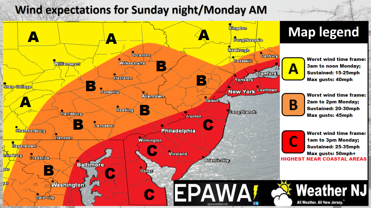
Click here for full resolution wind map.
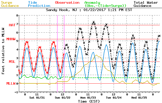
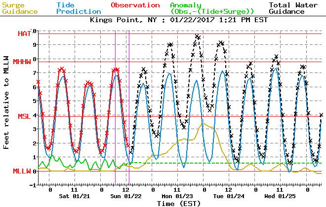
Coastal Flooding Discussion
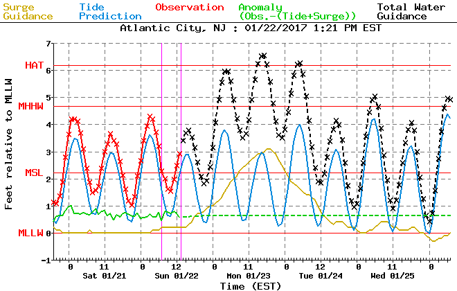
This event should elevate tidal levels for all coasts along the Delaware Bay, Atlantic Ocean, Raritan/Lower Bays, and Long Island Sound. The following tidal guidance from the NWS Meteorological Development Laboratory represents key points along the Jersey coast with respect to actual water levels. The last one for Kings Point, NY is the best indicator for the western-most part of the Long Island Sound. All other areas are coastal NJ points.
The gold line represents the modeled storm surge (sea water pushed into NJ coast and back bays from the strong winds off the ocean). The blue line represents modeled tide levels. Therefore to get an expected total storm tide you add the gold and blue lines together. The result is the dotted-black line which models the expected actual/total storm tide level in feet above MLLW. The United States’ National Oceanic and Atmospheric Administration uses mean lower low water (MLLW), which is the average height of the lowest tide recorded at a tide station each day during the recording period (the National Tidal Datum Epoch – a 19 year period).
Your main concern is the black dotted line. As you can see, there are about 3 high tides where the storm tide will flirt with or exceed 6 feet above MLLW. This isn’t catastrophic. NJ has seen this many times. Areas that normally flood will likely flood. It does appear that the northern Jersey coast should see levels higher than the southern Jersey shore. I’m still leaning towards minor-to-moderate coastal flooding for all points concerned and that’s backed by the following tidal guidance:

In English: A strong coastal storm is approaching. Conditions should deteriorate later this evening and into overnight hours. Peak coastal storm conditions (represented by the impact maps above) should occur between the early AM hours of Monday and Monday evening. In general rainfall amounts of 1-2 inches with isolated areas of 2+ are possible throughout all of New Jersey. NWNJ could deal with some wintry precipitation mixing into the rain. We’re watching this closely in case the NWNJ elevations over-perform on the colder side. It would take thread the needle timing. Certainly still possible but sloppy wet snow is the most probable right now. It’s a wildcard possibility for more than an inch to fall and we’ll have to call that in live-casting. For everyone else (lower 2/3 of NJ), it’s a rain and wind event. Winds will be very noticeable statewide (both at sustained and maximum gust levels). There’s no reason why immediate coastal regions cannot gust to 60mph+. With that said, power outages are possible. Minor-to-moderate coastal flooding is expected for all NJ coasts. Everything should begin to improve on Tuesday and clear by Tuesday night. Please be safe! JC
Jonathan Carr (JC) is the founder and sole operator of Weather NJ, New Jersey’s largest independent weather reporting agency. Since 2010, Jonathan has provided weather safety discussion and forecasting services for New Jersey and surrounding areas through the web and social media. Originally branded as Severe NJ Weather (before 2014), Weather NJ is proud to bring you accurate and responsible forecast discussion ahead of high-stakes weather scenarios that impact this great garden state of ours. All Weather. All New Jersey.™ Be safe! JC


LOCAL FORECAST | INTERACTIVE RADAR | LATEST NJ WEATHER ALERTS | WEDDING FORECAST| PRIVACY POLICY
© Copyright 2026 Weather NJ LLC. All Rights Reserved.
Some information that can be found on our website is provided by a private weather station and is not an officially recognized station for weather reporting. Though we always strive to achieve accurate reporting for our own use, it is important that you do NOT depend on the data provided here for any purpose.
