

Jan 22: Winter Storm Detected
Discussion: A shot of Arctic air will move in from the NW starting tonight and will linger until Sunday. This should keep most, if not all, of NJ below freezing during this period. NNJ elevations and maybe Pine Barrens down into single digits overnight into Sunday. Likely the coldest air we’ve seen yet this season. I would expect breezy conditions out of the NW through Saturday then winds subsiding by Sunday night. We have cold air moving across the Great Lakes so cannot rule out flurries, snow showers, or even a squall. Otherwise, skies should be mostly dry. By late Sunday morning, temperatures should begin moderating ahead of the expected early week winter storm.
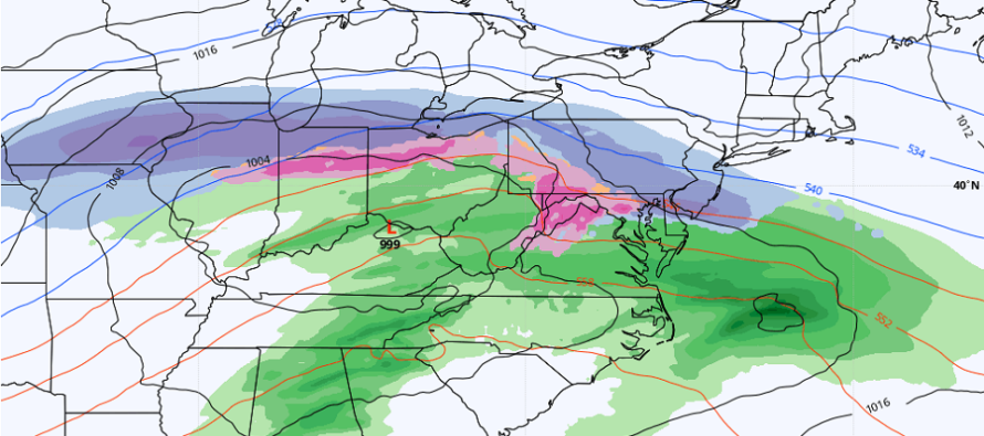
This signal has been well advertised for about a week on long-range model guidance. The setup is a very flat/zonal jet placement across the Mid-Atlantic US from W to E. A low will try to cut into the Pittsburg area then gradually transfer to the Atlantic Ocean. To our N, we’ll have a very strong high pressure area (~1040mb) hurling front-side anti-cyclonic flow at NJ. This high pressure is what would force a transfer but also provides Arctic air reinforcement. So, we’re going to see a pretty tight thermal gradient from W to E and likely right across NJ. NNJ and SNJ worlds apart in temperature and snow ratios. But wherever that Arctic wall sets up, it will be heavy snow to the N of it and rain to the S of it. Periods of sleet cannot be ruled out depending on low-mid level layers of above-freezing temps…and how far they stick their nose N.
With that said, the best I can do for now is split NJ across from W to E at I-195. Areas N of I-195 have the best chance to see all snow from this. Areas S of I-195 would then have a better chance at seeing a front-end snowy thump/rain and sleet mix in the middle/snowy finish kind of thing. We’ll likely start issuing snow maps tomorrow after reviewing more data.
As far as timing goes, most of Monday morning and afternoon should be alright. The precipitation will approach from the SW Monday evening and likely not spread into all of NJ until late Monday night or even early Tuesday morning. The snowy thump for most would then happen from early-to-late Tuesday morning. A dry slot should be heavily considered given the transfer in low pressure. As of right now, the dry slot would likely occur Tuesday afternoon-evening as warmer temperatures creep N in NJ. Then once the low is out and to our E, temps would theoretically fall and chance precip back to light ending snow for all areas. The back-side of the low will pull cold down with negative resistance from the high (quick temp crash). Per the current guidance the system tapers off by late Tuesday night as all light snow. I’m hesitant to put numbers to any location right now. But it does look like a light-to-plowable event overall, especially N of I-195.
Then another storm signal exists for Thursday into Friday. This one more of a cold coastal with SENJ favored for the most snow. It’s still very early and this early-week storm will have a lot to do with setting the later-week coastal up. Keeping that on the back burner until closer to the early-week system.
In English: The weekend is easy. Cold, breezy at times (wind chills), and mostly dry. I say mostly because we cannot rule out passing flurries or snow showers if the lake effect machine is turned on. A winter storm is becoming likely for Monday PM through Wednesday AM (mostly impacting Tuesday). Tomorrow we will start issuing snow maps but as of now, looks at least plowable for much of NJ. Then another storm signal for next Thursday-Friday…more of a coastal. It’s starting to pick up and we know the pattern supports it! Have a great rest of your Friday and please be safe! JC
Download the free Weather NJ mobile app on Apple or Android. It’s the easiest way to never miss Weather NJ content. Our premium services go even further above and beyond at the hyper-local level. Get your merch on at the KABOOM shop in time for the holidays.
Jonathan Carr (JC) is the founder and sole operator of Weather NJ, New Jersey’s largest independent weather reporting agency. Since 2010, Jonathan has provided weather safety discussion and forecasting services for New Jersey and surrounding areas through the web and social media. Originally branded as Severe NJ Weather (before 2014), Weather NJ is proud to bring you accurate and responsible forecast discussion ahead of high-stakes weather scenarios that impact this great garden state of ours. All Weather. All New Jersey.™ Be safe! JC


LOCAL FORECAST | INTERACTIVE RADAR | LATEST NJ WEATHER ALERTS | WEDDING FORECAST| PRIVACY POLICY
© Copyright 2026 Weather NJ LLC. All Rights Reserved.
Some information that can be found on our website is provided by a private weather station and is not an officially recognized station for weather reporting. Though we always strive to achieve accurate reporting for our own use, it is important that you do NOT depend on the data provided here for any purpose.
