

Jan 23: Coastal Storm Update
The coastal storm is well underway but peak intensity is still to come. Let’s break it down…
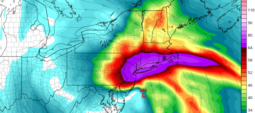
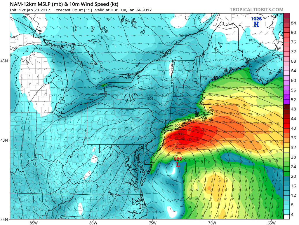
Right now, the primary surface low is about 988mb and tracking from W NC to OBX. Upper-level lows are closed off from 300-700mb which should keep the surface low strong as it ejects into the Atlantic Ocean and retrogrades close to the Jersey coast later today/this evening. The low’s intensity is modeled to be about 985-988mb when off the SENJ coast. This is when winds will really crank off the ocean during heavy rainfall. So right now, we’re at about 50% storm intensity with a peak intensity expected between 1PM and 10PM. The above cover image shows 850mb winds during peak conditions around 10-11PM tonight. Surface winds are less but this illustrates how strong the 850mb lower-level jet is going to be. Units are in knots. Here’s the surface wind profile for 9-10pm:
There are a few trends in model guidance worth discussing. First are the increased snowfall amounts for NWNJ. The surface models that are outputting more snow are deriving their temperatures from the 850mb level which is colder. However, the strong dynamics are forcing a warm layer inward off the ocean at 700mb…where you need cold for frontogenic forcing to produce significant accumulations. This, in theory, should deform the snow production into sleet or mixed wet snowflakes. Therefore, we still feel that a pasty layer of wet snow/sleet is a more rational outcome than significant snow accumulations. I’ll continue to watch this but those are my thoughts on more snow than rain for now.
Another trend is the extension of timing. While the peak storm conditions should occur between 1PM and midnight, we will likely need all of overnight tonight and some of tomorrow for everything to clear out and wrap up. If the low lingers off the coast through most of tomorrow, then so will the rain and wind…just not as intense as it will be later today. And winds will be more northerly which will help tidal waters subside.
In English: Rain has spread into at least SNJ and parts of CNJ. Rain will continue to spread into NNJ through afternoon hours. Winds are already whipping but will really start to crank this afternoon through evening hours. During this time, I’ll be watching for “how wintry NWNJ becomes” and “how bad the coastal flooding gets” from peak onshore winds. One high tide (this morning) is down. Two more high tides to go within the period of concern…one tonight and the other early tomorrow. It wouldn’t take much for coastal flooding to be hoisted from minor-moderate to the higher end of moderate. The bottom line is that we’re in for a long 12 hours or so, especially the coast. Please be safe! JC
Jonathan Carr (JC) is the founder and sole operator of Weather NJ, New Jersey’s largest independent weather reporting agency. Since 2010, Jonathan has provided weather safety discussion and forecasting services for New Jersey and surrounding areas through the web and social media. Originally branded as Severe NJ Weather (before 2014), Weather NJ is proud to bring you accurate and responsible forecast discussion ahead of high-stakes weather scenarios that impact this great garden state of ours. All Weather. All New Jersey.™ Be safe! JC


LOCAL FORECAST | INTERACTIVE RADAR | LATEST NJ WEATHER ALERTS | WEDDING FORECAST| PRIVACY POLICY
© Copyright 2026 Weather NJ LLC. All Rights Reserved.
Some information that can be found on our website is provided by a private weather station and is not an officially recognized station for weather reporting. Though we always strive to achieve accurate reporting for our own use, it is important that you do NOT depend on the data provided here for any purpose.
