

Jan 23: Tracking Two Wintry Systems
Discussion: We currently have high pressure (anti-cyclonic flow) to our W and low pressure (cyclonic flow) to our E. This is producing a tight N to S pressure gradient (strong N/NW flow) and tapping Arctic air mass over Canada. For these reasons we are cold and will likely bottom out the coldest of the weekend just before daybreak on Sunday morning. The low-dewpoint drier air allows afternoon high temperatures to creep slightly above expectations. However, in return, overnight low temperatures should creep slightly below expectations. The breezy winds out of the NW are making it seem even colder than it is. As they subside overnight under clear skies, radiational cooling will probably bust expected temperatures colder than what your apps are telling you. The weekend will remain cold and dry except for a small chance of lake-effect flurries or snow showers.
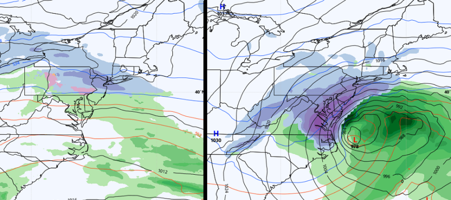
Next week looks very uncertain. I’m now tracking two systems which appear to be gravitating towards each other in timing. Going into this weekend, the first system was modeled for Monday into Tuesday and the second system, Thursday into Friday. Now the systems are modeled to happen between early Tuesday AM and late Thursday PM. It will be interesting to see if this trend continues and how close the systems get between now and then. However for now, they can still be considered two separate events.
The first system (today’s 12Z Euro shown on left side of cover image) still looks like a series of weak low pressure transferring through the region from W to E. The primary low tracks across IN/OH then transfers from ~Pittsburgh to the Atlantic Ocean. Areas in NJ N of I-195 are looking at 2-4, maybe 3-6 with higher snow ratios in play. NWNJ elevations would likely be the jackpot accumulation area. Therefore, periods of all snow are likely in NJ, N of I-195, from early Tuesday AM through late Tuesday PM. Areas S of I-195 are looking at a brief snowy start (a coating to an inch or two) Tuesday AM that changes over to sleet and rain for Tuesday afternoon. As temps become colder after sunset, rain should change back to at least flurries, possibly light accumulating snow, for areas in NJ, S of I-195. I want to re-emphasize that this does not seem like a hard-hitting snowstorm with ridiculous snow rates. It seems much more like a prolonged light 12-hour event with lighter snow rates. If the front-end thump over-performs or some meso banding occurs as a wildcards then so be it. But those are not currently being forecasted with high probability. Honestly, light snow even if just flurries, are possible Tuesday night through Wednesday ahead of the approaching second system with not much of a break between.
The second system (today’s 12Z GFS shown on right side of cover) has a lot of moving parts. The system transfers in from the W US and re-forms somewhere over the SE US around Wednesday morning. From there it tracks up the east coast favorably for a Mid-Atlantic US snowstorm on Thursday. The low is modeled to deepen below 980mb on most model guidance once out near the 40N/70W benchmark. With that said, we really need to watch this. It’s currently modeled to hit N VA and MD hard with snow. We have 5 days for that to trend and this first system’s wake influences the second systems track and impact on NJ. It wouldn’t take much change in model guidance to extend the larger snow zone into SNJ for the second system.
With everything said, we need to take a step back and just know that the period between late Monday night and early Friday morning seems very wintry. First a weak wave on Tuesday then something with larger potential on Thursday. No snow maps yet even for Tuesday. We’ve decided to hold off another day and watch the shorter-range model data further evolve.
In English: Tonight into tomorrow morning should be the coldest period of the weekend. Wind chill factors should persist but winds should subside overnight tonight. Tomorrow should be a little milder than today. Then Monday back up near 40 for a few hours before temps fall back below freezing Monday evening. Not much new to report for the upcoming snow chances this week. Still tracking at least a light snow event late Monday night through Tuesday for NNJ. SNJ could start with snow but should eventually change over to rain. We see the snow/rain line starting in extreme SNJ Tuesday AM then advancing northward to about I-195 by Tuesday noon. Tuesday night that snow/rain line should crash back southward and possibly end SNJ areas with some snow but not much. Then there’s likely a coastal winter storm developing for Thursday currently targeting NJ (SNJ favored) for light-to-moderate snow. Way too much uncertainty to make any concrete snow map predictions at this point. That will come tomorrow for the first system. Just know that the next week or so should be wintry. Have a great rest of your Saturday and please be safe! JC
Download the free Weather NJ mobile app on Apple or Android. It’s the easiest way to never miss Weather NJ content. Our premium services go even further above and beyond at the hyper-local level. Get your merch on at the KABOOM shop in time for the holidays.
Jonathan Carr (JC) is the founder and sole operator of Weather NJ, New Jersey’s largest independent weather reporting agency. Since 2010, Jonathan has provided weather safety discussion and forecasting services for New Jersey and surrounding areas through the web and social media. Originally branded as Severe NJ Weather (before 2014), Weather NJ is proud to bring you accurate and responsible forecast discussion ahead of high-stakes weather scenarios that impact this great garden state of ours. All Weather. All New Jersey.™ Be safe! JC


LOCAL FORECAST | INTERACTIVE RADAR | LATEST NJ WEATHER ALERTS | WEDDING FORECAST| PRIVACY POLICY
© Copyright 2026 Weather NJ LLC. All Rights Reserved.
Some information that can be found on our website is provided by a private weather station and is not an officially recognized station for weather reporting. Though we always strive to achieve accurate reporting for our own use, it is important that you do NOT depend on the data provided here for any purpose.
