

Jan 24: The Return of Cold
The January thaw is about to end as we approach a prolonged period of cold. Let’s break it down…
First, a quick recap of the coastal storm. NWNJ saw wintry precipitation in the form of mostly sleet/some wet snow. The rest of interior New Jersey saw moderate-to-heavy rainfall and lesser winds. The higher winds hugged the immediate coast. I believe Cape May saw the highest wind gust of 63mph. I know I felt a few 50-55mph gusts on LBI. Power outages were (still are) scattered affecting thousands. Coastal flooding was on the minor side for the first high tide Monday morning. Monday evening and this morning’s high tides were closer to the moderate side. I saw a few delayed openings announced this morning for such. We were lucky that the strongest surge hit during low tide…and that we weren’t subject to a true new moon (this Friday the 27th). That could have added a few feet to the water levels. Otherwise, this was a run-of-mill coastal storm/nor’easter for New Jersey.
Real quick, the weather leading up to this weekend looks mild and uneventful. Highs in the 40s/50s, dry and sunny, and not too cold overnight. Right now a weak disturbance could bring some precipitation Thursday night into Friday but that will end the January thaw that we’ve experienced for the past few weeks. The initial cold front will roll through for the weekend.
From this Friday (Jan 27th) through as far as I can see on model guidance (Feb 9th), we’re going to be cold enough to support snowfall. As of right now there is no specific threat modeled however multiple shortwaves are modeled to swing through the E US on separate jet streams while ridging spikes back and forth over the W US. Essentially all the ingredients are there for a winter storm to happen. We just need everything to time together favorably. If that happens then we’ll find ourselves discussing/tracking a winter storm within a 4-7 day forecasting period. If not, then this Jan 27-Feb 9 cold period will goes to waste for the snow lover (or be appreciated by those who dislike snow). It is what it is.
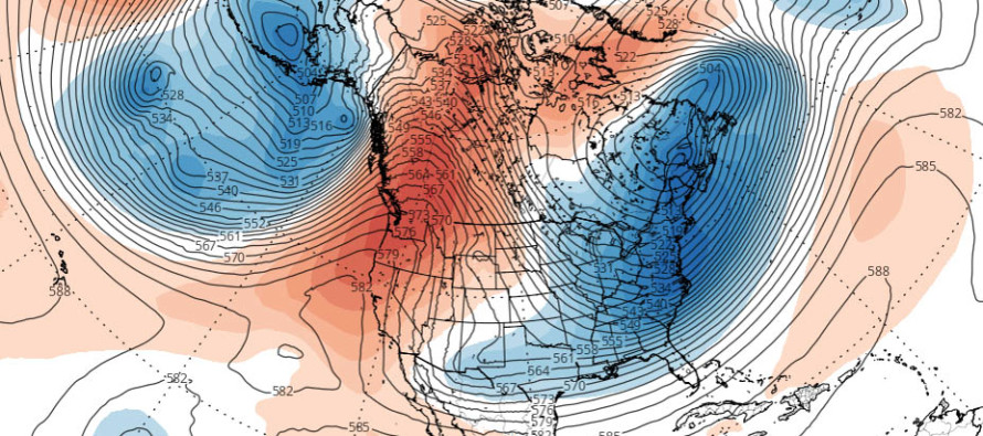
FWIW, the above cover image represents 500mb height anomalies on Jan 28th. Pressure decreases as you ascend in elevation. Therefore the exact height of 500mb is very telling for surface temperatures below. In areas where 500mb occurs higher than average, you can expect a warmer surface (warm surface air expands). Therefore in areas where 500mb occurs lower than average, you can expect a colder surface (cold surface air compacts). This colder upper-level look dominates the E US for the Jan 27-Feb 9 period and that’s one of the favorable signals I’m seeing.
In English: We’ll need most of today for remnant light precipitation to pull away with the departing coastal storm. Winds are now lighter and out of the N and therefore tidal waters can subside before the next high tide this afternoon/evening. We’re then dry, sunny and on the mild side until Thursday. Some frontal precipitation is possible Thursday into Friday but that will be along a cold front that kicks off a prolonged period of colder weather. I’m talking highs maxing out in the 30s and overnight lows into the teens/20s. The return of wintry temperatures! There are no specific winter storm threats modeled as of right now but I’ll be watching the general Jan 27-Feb 9 period closely for any development. It DOES look favorable however as we all know that DOESN’T guarantee it will produce snow at the surface. One 4-7 day forecasting period at a time is the best way to play it. I can assure you I’ll start making videos if something comes into fruition. Have a great day and please be safe! JC
Jonathan Carr (JC) is the founder and sole operator of Weather NJ, New Jersey’s largest independent weather reporting agency. Since 2010, Jonathan has provided weather safety discussion and forecasting services for New Jersey and surrounding areas through the web and social media. Originally branded as Severe NJ Weather (before 2014), Weather NJ is proud to bring you accurate and responsible forecast discussion ahead of high-stakes weather scenarios that impact this great garden state of ours. All Weather. All New Jersey.™ Be safe! JC


LOCAL FORECAST | INTERACTIVE RADAR | LATEST NJ WEATHER ALERTS | WEDDING FORECAST| PRIVACY POLICY
© Copyright 2026 Weather NJ LLC. All Rights Reserved.
Some information that can be found on our website is provided by a private weather station and is not an officially recognized station for weather reporting. Though we always strive to achieve accurate reporting for our own use, it is important that you do NOT depend on the data provided here for any purpose.
