

Jan 25: Light Wintry Event Approaching
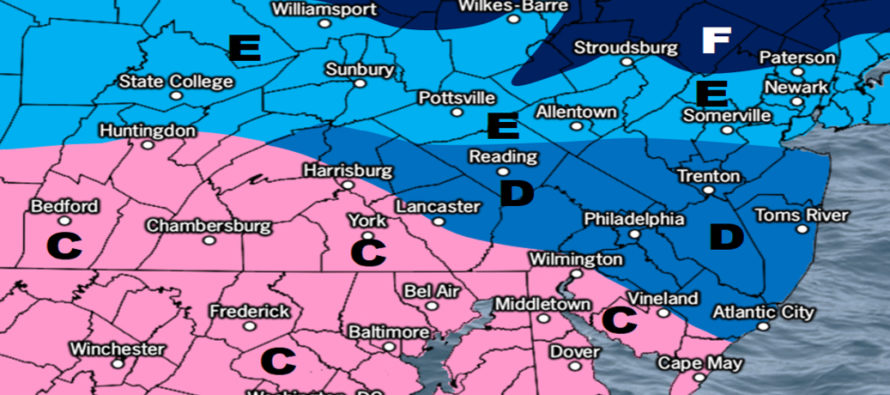
Discussion: Precipitation just ahead of a warm front (currently over KY/WV/VA) is moving in from our SW. It should first move into SWNJ anytime after sundown tonight as snow and then try to spread into SENJ and maybe even CNJ later tonight into tomorrow morning. It will face a lot of dry air which should inhibit the N/NE extent of the precip shield. But where it can fall, it could thump for a few inches before changing to rain. This represents the snow chances for zones C and D on our map. Zone C is the most favored for light snow accumulations. Zone D is only looking at nuisance snow at best. If the dry air wins out, not much could fall in zone D at all other than rain later in the system.
The snow/rain line should push northward Tuesday AM to at least I-195, possibly up to I-78. We expect sleet and/or freezing rain as the snow/rain line advances. This should keep areas to the S of this line under periods of rain for the remainder of the event (late Tuesday AM through early Wednesday AM). However, areas to the N of the snow/rain line (Zones E and F) are favored to remain snow from noon on Tuesday into Wednesday AM. With that said, we believe up to 4 inches are possible for the highest NJ elevations. The lower elevations of NNJ (N of I-78) should see somewhere between 1-3 inches of snow when all is said and done.
Remember, this is a long duration light snow/rain depending how far N/S you are. Not a big event by any means but travel could be disrupted with light snow and ice in the game. Zones C and D are primarily impacted tonight into tomorrow morning. Zones E and F’s precipitation is not expected until noon on Tuesday lasting into Wednesday AM. So SNJ first, NNJ after. Here is the last forecast map we’ll issue ahead of the arriving precipitation. Live observations and real-time updates only from hereon.
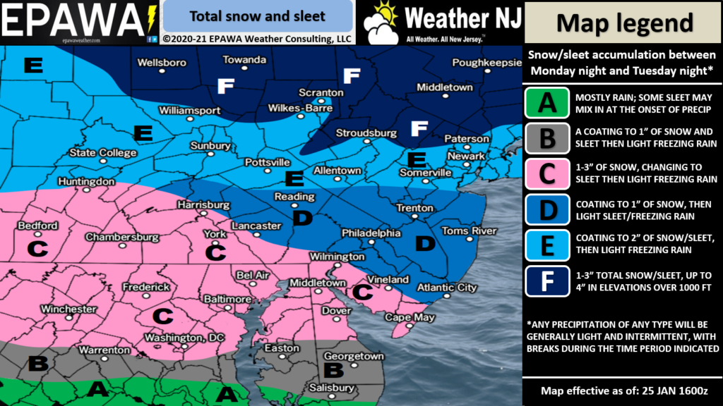
Full-resolution wintry impact map.
Models took the Thursday (Jan 28) coastal system further S overnight but have since brought it back a bit N today. Just enough to call for at least light snow showers in SENJ Thursday. I’ll be watching how that evolves as we closer approach. The next synoptic signal beyond that is for Sunday (Jan 31). Both the Thursday and Sunday system are expected to pull some pretty cold air down behind them. With that said, we remain in a favorable active pattern but without any solid hits.
In English: A light wintry event is approaching. Not big snow by any means but capable of slicking up untreated roads with either light snow accumulations or ice. SWNJ, maybe parts of SENJ, should see the most from the colder front-end of the system tonight into tomorrow morning. CNJ should deal with the icing tomorrow mid-to-late morning. Then NNJ should see all light snow Tuesday noon into Wednesday AM while SNJ rains. A large part of CNJ should see very little impact at all. It’s really only SWNJ and NNJ elevations where we expect snow accumulations. The Thursday system currently looks to graze SENJ with snow showers at most. Watching to see if it comes further N. Then another wintry signal for Sunday. I’ll check in on the radar later this evening. Have a great night and please be safe! JC
Download the free Weather NJ mobile app on Apple or Android. It’s the easiest way to never miss Weather NJ content. Our premium services go even further above and beyond at the hyper-local level. Get your merch on at the KABOOM shop in time for the holidays.
Jonathan Carr (JC) is the founder and sole operator of Weather NJ, New Jersey’s largest independent weather reporting agency. Since 2010, Jonathan has provided weather safety discussion and forecasting services for New Jersey and surrounding areas through the web and social media. Originally branded as Severe NJ Weather (before 2014), Weather NJ is proud to bring you accurate and responsible forecast discussion ahead of high-stakes weather scenarios that impact this great garden state of ours. All Weather. All New Jersey.™ Be safe! JC


LOCAL FORECAST | INTERACTIVE RADAR | LATEST NJ WEATHER ALERTS | WEDDING FORECAST| PRIVACY POLICY
© Copyright 2025 Weather NJ LLC. All Rights Reserved.
Some information that can be found on our website is provided by a private weather station and is not an officially recognized station for weather reporting. Though we always strive to achieve accurate reporting for our own use, it is important that you do NOT depend on the data provided here for any purpose.
