

Jan 25 Mid-Storm Update
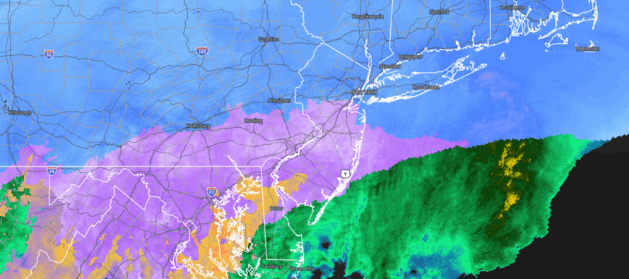
Discussion: Snow moved into Cape May early this morning (just after midnight). I was watching the Cape May Cove web cam so I knew when it began. I stayed up until the snow reached my latitude around 2-3am and called it a night. Snow had just transitioned from super fine flurries to a steadier rate. I woke up this morning to about 4 inches and watch it climb to about 8 inches. Cape May clocked a 6 inch report. Little Egg Harbor, a 7, Manahawkin 8, and a few 9s and 10s in N/NW Ocean County were some of the highest I saw in those areas. Overall, most locations in our C and E zones met the medium-to-high range of our expectations. CNJ seems very mixed but there is more drifting being reported there. I’ve seen some as low as 7 others as high as 11. This would be the area between I-195 and I-78. The snow/sleet line right now is somewhere between I-78 and I-80 and everyone N of that is still ripping snow with may over 12 already. The snow/sleet line has come to a pause like I showed on the HRRR in last night’s video. This is what will allow NNJ to continue to accumulate snow while CNJ/SNJ remain shut off from snow in a current ice storm. Bobby Martrich drew this graphic up to show the current precipitation type divisions across NNJ/CNJ (as of about 3pm).
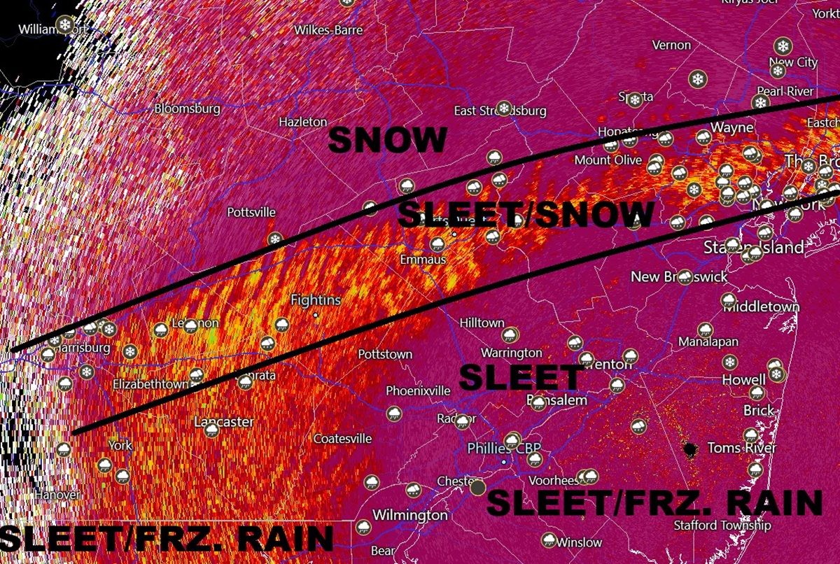
Phase I concluded today the minute you started to realize sleet. Maybe you heard it against your roof, windows, etc. Maybe you looked outside and saw pellets bouncing on surfaces. However it may be, the sleet marks the end of the snowfall for SNJ, CNJ and now southern parts of NNJ S of I-80. We are now in phase II of the system as laid out in yesterday’s article. Phase II is where the snow/mix line advances northward into NJ to its maximum extent and delivers an ice storm for much of NJ. I’m looking at surface temperatures and almost everyone W of the Garden State Parkway, from about Toms River down to Cape May County are still 32 or below. As soon as you get about 20-25 miles away from the ocean interior SNJ is still in the teens and 20s even down into parts of Salem/W Cumberland Counties. With that said, sleet and freezing rain is going to be the primary form of precipitation for at least the next several hours. Plain rain (rain falling on 32 and above surfaces) remains pinned along and E of the Garden State Parkway. I expect this freezing rain/rain line to work its way a little further into SENJ over the next few hours but not much further. Our sleet and freezing rain/rain maps now come into play for phase II which again, we are now firmly into.
Our primary low is in the process of transferring to a secondary coastal low. Sometime between sunset and about midnight, phase II will end when the snow/sleet line reaches its maximum extent. This could be along I-80 or maybe slightly N of there which means areas N of that remain all snow. That is why we upgraded that zone to a 16-20 expectation. I saw a 13.5 observation already up there. Regardless, the coastal low will be established and will begin pulling colder air in back from the N. This should lower the snow/sleet line back to about I-78 for our third and final phase. And then I-78 on north can snow lightly well into Monday morning but likely no later than noon. At this point, I do not think the backside of this changes back to snow for areas S of I-78.
Our final call snow map from yesterday did pretty well though (so far for phase I across CNJ/SNJ). The upgrade we put out today includes both snow + sleet also includes light snow showers through noon on Monday. Remember, sleet accumulates at about an 8:1 ratio. Will be interesting to see how final totals play out tomorrow. I’m approaching an inch of sleet on top of my 8.3 of snow (avg of 8, 8, and 9 IMBY) inches in SNJ and have no doubt I’ll get to 10 from both. I’m between Philly and Toms River latitude.
In English: This storm is going about as expected as it can given the Warm Air Advection (WAA) involved (the transition from snow to mixed) and so many other moving parts. From this point on, we have to recognize the safety hazards. The sleet, freezing rain and rain (S of I-78) are going to take normal snow hazards and up it X 10. Travel conditions are bad out there and you should stay in tonight/tomorrow if your situation allows. Ice just makes things so much worse. Many schools are closed alralread, and I imagine other closings and cancellations will happen for non-educational sectors. For areas that see rain in SENJ, that’s going to wash away salt ahead of the return to Arctic temps for said areas tomorrow. Those areas are going to need resalting. For areas N of the current snow/sleet line (between I-78 and I-80), continued snow accumulations above 12 will do the typical damage that a KABOOM does. Again, one thing we have working for us is reasonable winds, not horribly gusty like a blizzard. That will mitigate power outages some but not completely. I’ll put out another live observation reel later this evening/tonight when Phase II ends and Phase III begins. Please stay warm and be safe! JC
Premium Services
KABOOM Club offers an ad-free environment, inside info (Above and Beyond) forecast discussion, your questions prioritized, and early storm impact maps and video releases (ahead of the public). At $1.99 per month, it’s an extremely feasible way to show additional support for Weather NJ and you can turn it on and off for however many months you wish. Think of it as a tip jar with perks. Available onFacebook or Patreon.
My Pocket Meteorologist (MPM), in partnership with EPAWA Weather Consulting, offers professional/commercial interests, whose businesses depend on outdoor weather conditions (snow plowing, landscaping, construction, etc.), with hyper-local text message alerts/forecasts from real meteorologists and access to the MPM premium forum—the most comprehensive and technical forecast discussion available for PA and NJ commercial interests.
KABOOM Shop is live if you want some KABOOM or Weather NJ Merch!
Sign up for ZoneWatch Radar and get 10% off
Jonathan Carr (JC) is the founder and sole operator of Weather NJ, New Jersey’s largest independent weather reporting agency. Since 2010, Jonathan has provided weather safety discussion and forecasting services for New Jersey and surrounding areas through the web and social media. Originally branded as Severe NJ Weather (before 2014), Weather NJ is proud to bring you accurate and responsible forecast discussion ahead of high-stakes weather scenarios that impact this great garden state of ours. All Weather. All New Jersey.™ Be safe! JC


LOCAL FORECAST | INTERACTIVE RADAR | LATEST NJ WEATHER ALERTS | WEDDING FORECAST| PRIVACY POLICY
© Copyright 2026 Weather NJ LLC. All Rights Reserved.
Some information that can be found on our website is provided by a private weather station and is not an officially recognized station for weather reporting. Though we always strive to achieve accurate reporting for our own use, it is important that you do NOT depend on the data provided here for any purpose.
