

Jan 28: Arctic Cold Front Approaches
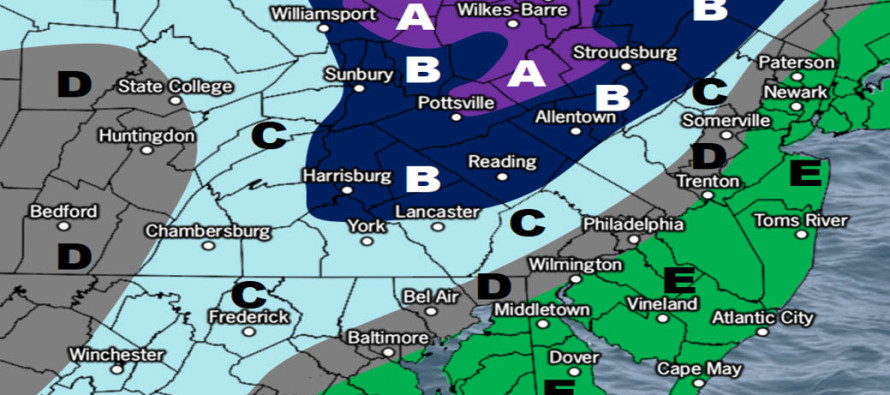

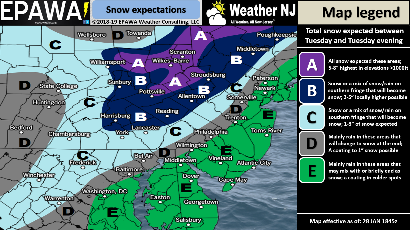
For full-resolution snow map please click here!
Discussion: An Arctic cold front is expected to push through tomorrow evening into Wednesday. This should result in below-average temperatures Wednesday through Sunday morning. The coldest period (extremely below-average) should be between Wednesday PM and Friday AM. Precipitation is expected along the Arctic front between about noon tomorrow (starting in NWNJ) and midnight tomorrow night (ending in ENJ). The primary low should pass through the Great Lakes while secondary energy rounds the trough of Arctic air and slides up the Arctic front. This might even spark a coastal low out to sea. Short-range guidance has trended a little colder and snowier so we’ve upped our amounts for NWNJ. I was just outside and noted how everything feels like snow.
NWNJ should could see precipitation begin as early as noon tomorrow. It might start as snow or go quickly over to snow if not and stay all snow. No surprises here as NWNJ is most favored for system jackpot accumulations. The lower elevations of NENJ and most of interior CNJ (areas NW of the turnpike) stand to see the biggest surprise if this thing comes it colder and wetter. SNJ, especially SENJ, is most-likely to start as rain before changing over to snow. For SENJ the changeover should occur later towards evening. Precipitation should shut off quick from W to E around midnight. When all is said and done we expect the outcome indicated by the impact map above. I would expect gusty winds and power outages associated mainly with frontal winds and any ice that forms on downable branches and power lines. Temperatures will be dropping fast for areas that might have started as rain. Therefore you could end up with low snow accumulations on top of ice. It doesn’t take much to make it slick. With that said road treatments are a smart move. Other than that get ready for some bitter cold.
In English: A rain-to-snow scenario is likely between noon and midnight tomorrow (Tuesday). NWNJ might start and stay all snow which is why they are most-favored on our above impact map. SENJ is favored for the warmest scenario of NJ but even SENJ should end wintry. The rest of the week then looks stupid cold. Download the new free Weather NJ mobile app on Apple and/or Android. It’s the easiest way to never miss Weather NJ content. Have a great night stay warm and please be safe! JC
Jonathan Carr (JC) is the founder and sole operator of Weather NJ, New Jersey’s largest independent weather reporting agency. Since 2010, Jonathan has provided weather safety discussion and forecasting services for New Jersey and surrounding areas through the web and social media. Originally branded as Severe NJ Weather (before 2014), Weather NJ is proud to bring you accurate and responsible forecast discussion ahead of high-stakes weather scenarios that impact this great garden state of ours. All Weather. All New Jersey.™ Be safe! JC


LOCAL FORECAST | INTERACTIVE RADAR | LATEST NJ WEATHER ALERTS | WEDDING FORECAST| PRIVACY POLICY
© Copyright 2025 Weather NJ LLC. All Rights Reserved.
Some information that can be found on our website is provided by a private weather station and is not an officially recognized station for weather reporting. Though we always strive to achieve accurate reporting for our own use, it is important that you do NOT depend on the data provided here for any purpose.
