

Jan 28: Winter Storm Chances Increasing
Discussion: The coastal storm that missed us to the S (bringing a swath of snow through parts of NC/VA) has departed well into the Atlantic Ocean. The backside of this cyclonic flow has pulled down more cold from the available Arctic air mass to the N. The system earlier in the week brought down the first gear of cold for Wednesday-Thursday. This is now the second gear. Overnight low temperatures should range from teens-to-20s from elevations to sea. Maybe single digits for some spots. It is possible that all of NJ doesn’t get back above freezing for the entire weekend. The NW winds should be strongest through Friday morning, maybe afternoon then subside for the rest of the weekend. Radiational cooling from clear skies and light winds could take temperatures even colder Friday and Saturday night. Either way, a very cold and dry weekend for NJ.
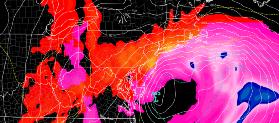
This sets the stage cold for the approaching snowstorm signal of Jan 31-Feb 2. The primary low has just entered the W US coast (off the Pacific) near the CA/OR border. It should track across the US to about KY (bringing a decent snowstorm to Chicago/IN/OH area) before transferring somewhere in the Atlantic Ocean just off S Delmarva or OBX. From there the secondary coastal wants to tuck in and stall/retrograde back towards incoming upper-level energy from the NW. As modeled verbatim, it would hold a precipitation shield over NJ and surrounding areas from early Monday morning to late Tuesday night.
No temperature issues for snow ahead of the storm (this weekend) however the secondary coastal low could track close enough to NJ for at least SENJ, maybe more of SWNJ/ECNJ to deal with mixing and rain at times on Monday. But once the low gets out in the ocean, winds will switch from E to N/NE and change the rain back to snow with all of Tuesday’s precipitation left to fall cold. The areas that never go over to sleet or rain would obviously end up with higher snow accumulations. It is uncertain how far inland that snow/rain line will get in SENJ. But it should at least be a nice SENJ kiss.
All the typical wildcards that surround a transfer snowstorm are on the table. The dry slot of precipitation between the transfer. The upper-level energy being slightly earlier or later (impacts the low’s distance from NJ)…reasons the snow could miss like recent events. There is also the cold conveyor belt energy which could dump redonkulous snow rates under heavy banding. But all that aside, the chances of NJ seeing at least a significant snow event, possibly major, are increasing. The plan is to issue the first map tomorrow but it may just be probabilities. Then traditional amounts maps Saturday and Sunday. We need to see a little more data consensus hold through the transition of mid-range to short-range. This is about the time when model guidance lost recent snowstorm chances.
It’s not like this is a textbook single low track Miller-A out of the Gulf with Arctic air in place. The many fluid components of transferring and retrograding energy suggest proceeding with cautious optimism (if you’re a snow lover like me).
In English: A significant-to-major snowstorm is possible for New Jersey this Monday-Tuesday. First, this weekend will be very cold ahead of this storm. This will likely mean an all-snow setup for NNJ and CNJ. SNJ, especially SENJ is looking at a front-end snow to rain back to snow scenario (typical). But the latest models still put down accumulating snow for all areas except maybe extreme SENJ. Obviously more for those who do not changeover to rain for the middle third of the storm. It could start as early as Sunday PM but we currently expect Monday-Tuesday to be the meat and potatoes of it. Models are trending S and there are a lot of moving parts. We’ll continue to review the data and issue a first map tomorrow. Have a great Thursday night and please be safe! JC
Download the free Weather NJ mobile app on Apple or Android. It’s the easiest way to never miss Weather NJ content. Our premium services go even further above and beyond at the hyper-local level. Get your merch on at the KABOOM shop in time for the holidays.
Jonathan Carr (JC) is the founder and sole operator of Weather NJ, New Jersey’s largest independent weather reporting agency. Since 2010, Jonathan has provided weather safety discussion and forecasting services for New Jersey and surrounding areas through the web and social media. Originally branded as Severe NJ Weather (before 2014), Weather NJ is proud to bring you accurate and responsible forecast discussion ahead of high-stakes weather scenarios that impact this great garden state of ours. All Weather. All New Jersey.™ Be safe! JC


LOCAL FORECAST | INTERACTIVE RADAR | LATEST NJ WEATHER ALERTS | WEDDING FORECAST| PRIVACY POLICY
© Copyright 2026 Weather NJ LLC. All Rights Reserved.
Some information that can be found on our website is provided by a private weather station and is not an officially recognized station for weather reporting. Though we always strive to achieve accurate reporting for our own use, it is important that you do NOT depend on the data provided here for any purpose.
