

Jan 29: Snow Storm a GO!
Discussion: I’m sorry but no map yet. There is still significant uncertainty as to where the exact jackpot axis of snowfall is going to set up through NJ and ultimately where the NW cutoff and SE snow/rain line will be. I believe solutions are converging on the heaviest hit areas being the general I-95 corridor and slightly SE (Philadelphia through NYC). I am very confident in a significant to possibly major (KABOOM) in NJ between this Sunday night and Tuesday. But there are a lot of moving parts and still almost 48 hours before the first flakes arrive.
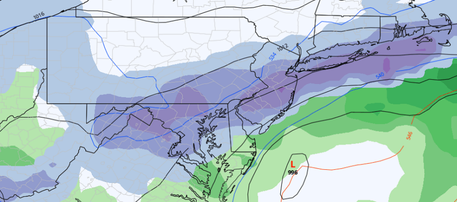
The setup has not changed. Primary low into KY then transfer (hits wall of high pressure) to Atlantic Ocean off S Delmarva/OBX. The coastal low redevelops and tucks into the Mid-Atlantic US coast—holding a precipitation shield over NJ and surrounding areas from Sunday night through Tuesday (includes all day Monday). I don’t have a forecast map but I’m happy to show you some model guidance. From top to bottom (GFS, Canadian, Euro, and NAM) expected snow accumulations through 7PM Tuesday night:
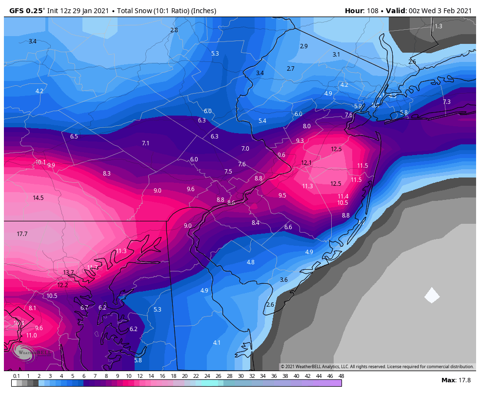
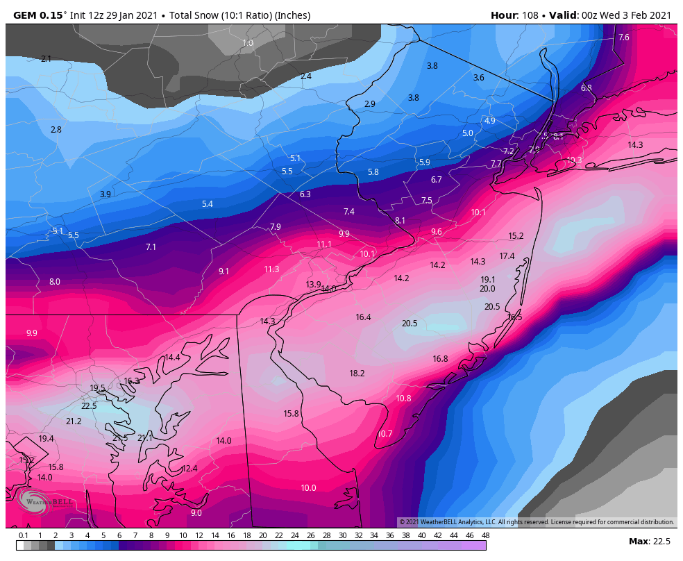
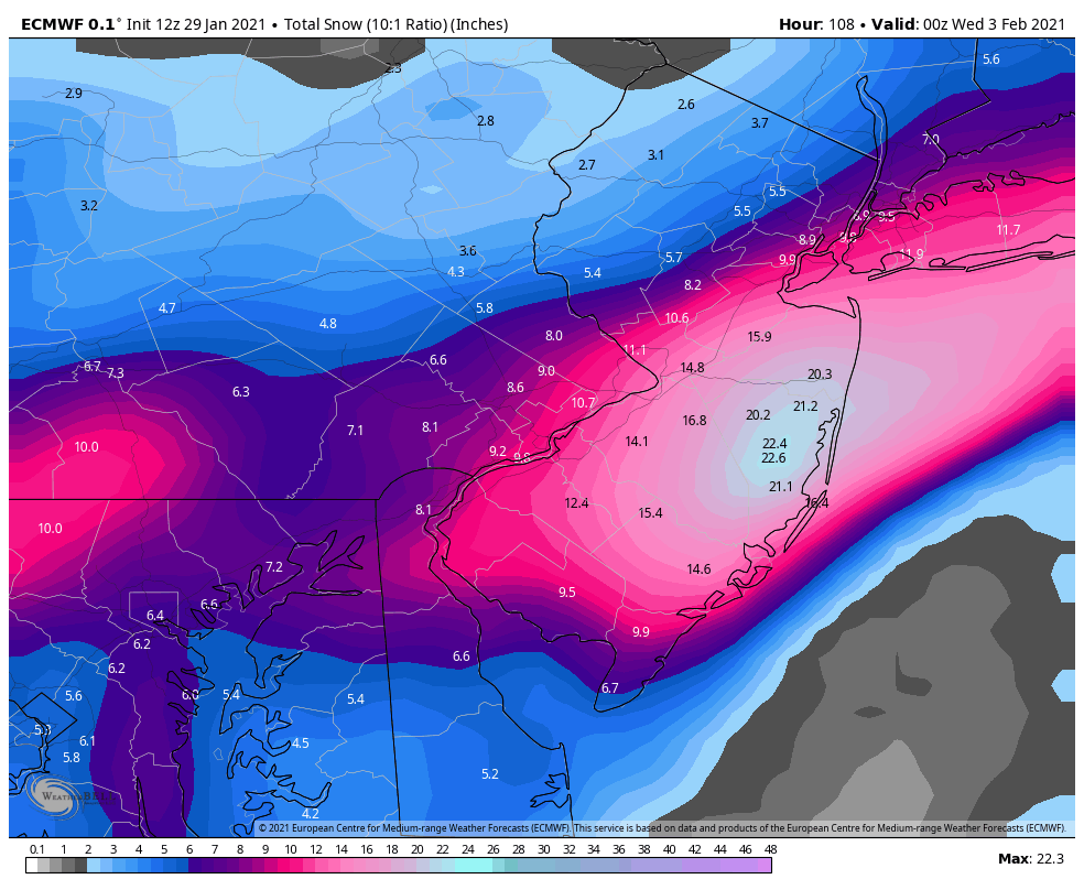
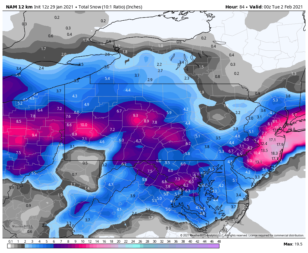
I am leaning more towards something between the Euro and GFS…sort of what the NAM is suggesting but a little more statewide. A Kaboom for CNJ and likely parts of NNJ and SNJ as well. Tomorrow we absolutely have to issue a forecast map and as of right now it will largely reflect these ideas which are closest aligned to real-world live observations. Now let’s talk timing and precipitation type.
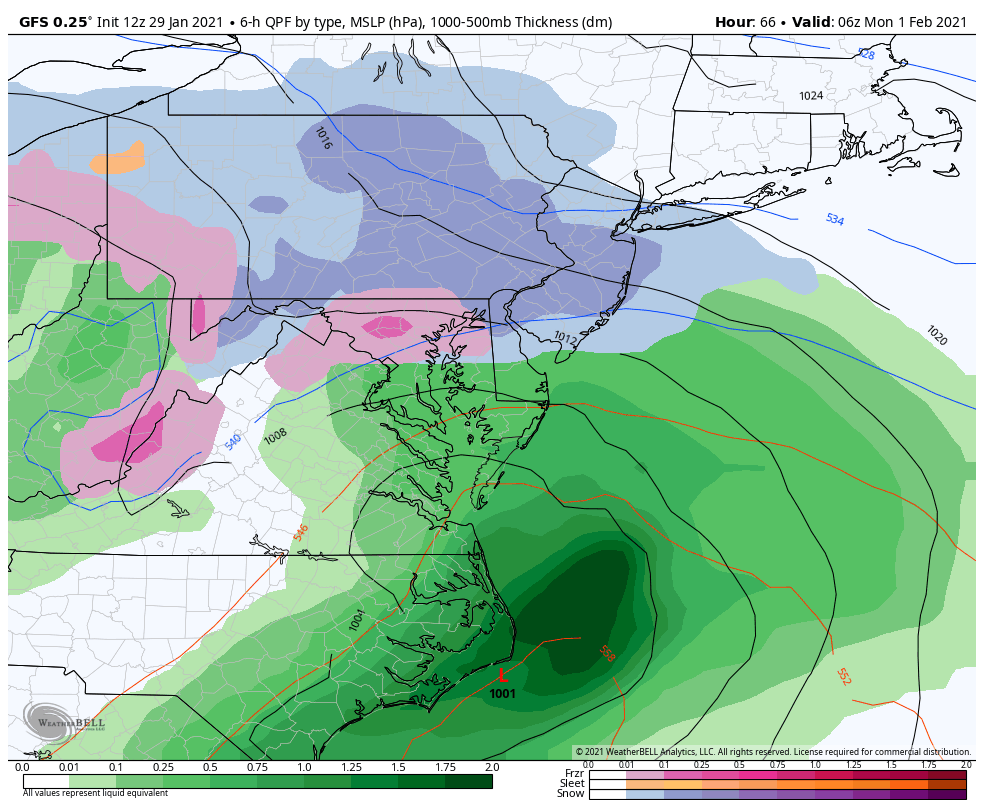
The storm is scheduled to arrive as early as Sunset Sunday night. This will likely be a thumping for most of NJ including SNJ. As we know, the ground and current air mass are cold. So this next image represents the general idea for Sunday night into early Monday AM hours:
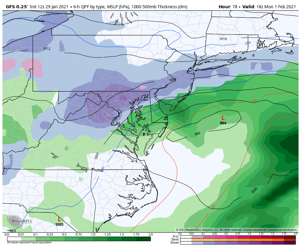
Then, between Monday AM and Monday afternoon, the snow/rain line will try to advance off the ocean into SENJ. This will be due to the low’s proximity throwing onshore warmer marine flow into the mix. The air is so cold however, we might see an Arctic wall of cold setup and hold the snow/rain line to extreme SENJ only (AC down to Cape May). The GFS shown here represents the general idea from Monday morning through Monday afternoon. The GFS is the furthest the snow/rain line gets. The Euro and Canadian hold it off so that even most of SENJ KABOOMS:
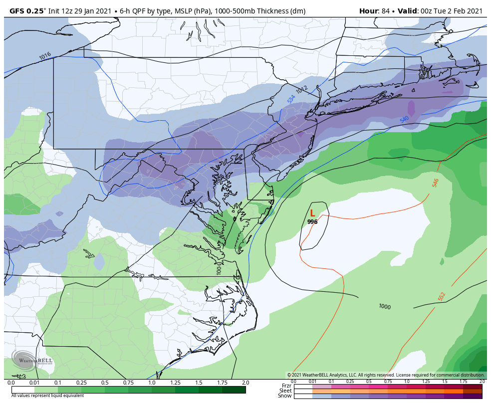
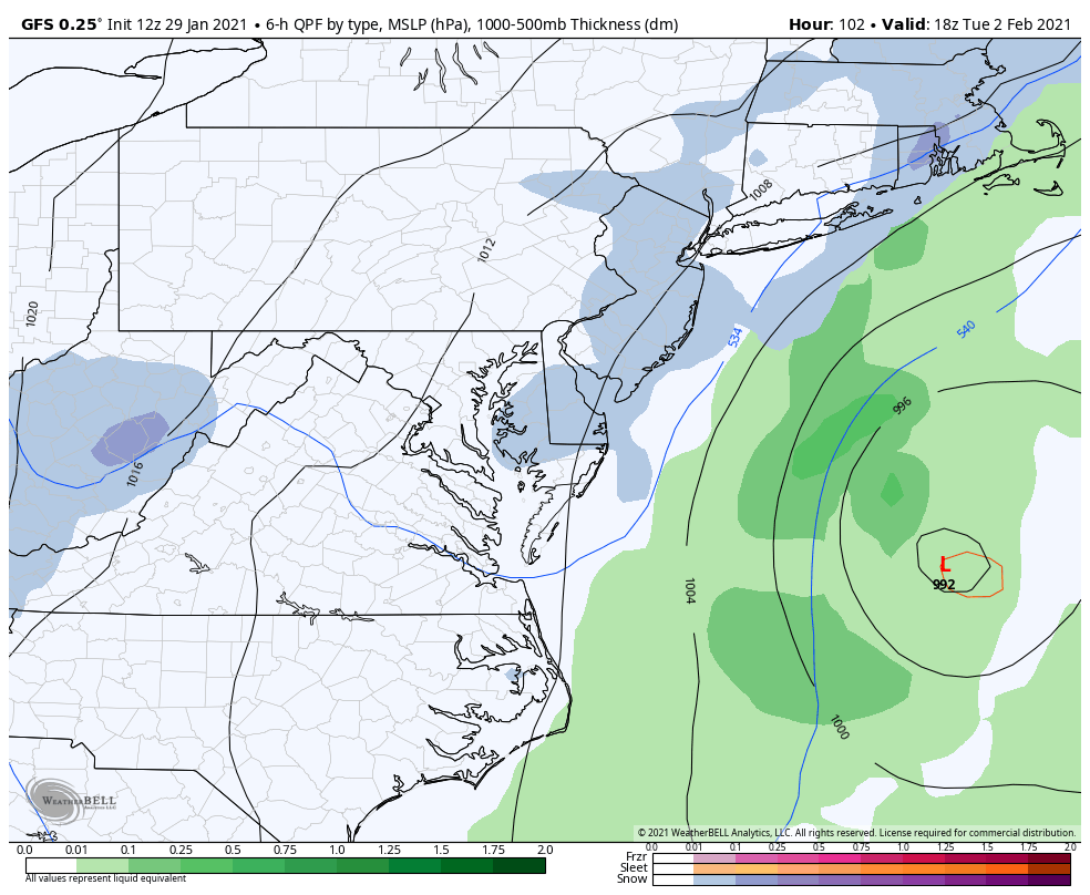
From about Monday afternoon and forward, rain in SENJ should change back to snow for the rest of the event (through Tuesday evening). Areas that never change over to rain should just continue to snow. This GFS image represents this general idea Monday night into Tuesday morning:
Snow should then taper off between late Tuesday morning and Tuesday PM as shown here:
So yeah, it looks like most of NJ is on the hook for at least significant snowfall, possibly a KABOOM (12 inches+). Most of NJ is looking good for at least 3+ result, even the places that get cutoff like extreme NWNJ and extreme SENJ. We have 48 hours of model runs and live observations to go to try and nail down who will see the 6-12+.
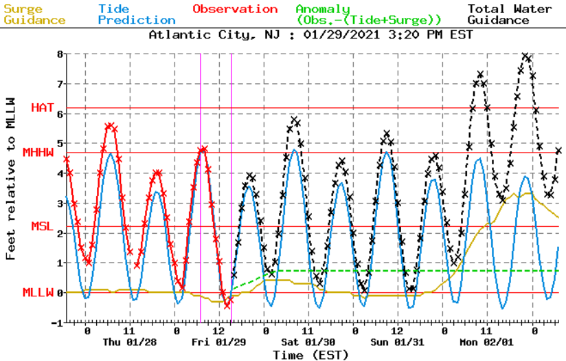
Lastly, let’s talk wind and coastal flooding. Tidal guidance is coming in with the suggestion of at least minor, likely moderate coastal flooding ~Sunday just before midnight and ~Monday just before noon. The wind-driven storm surge should make these two high tides the main periods of interest along the east-facing Jersey shore.
Between Sunday night and Tuesday night, winds are going to rock counter-clockwise in direction from E to N. These winds should easily gust to 50-60+ mph at times along the immediate ECNJ and SENJ coast. Areas away from the ocean should see lesser winds.
In English: NJ will likely get hit by a significant-to-major snow storm between Sunday night and Tuesday night. Some of SENJ could mix Monday morning but otherwise cold enough for snow for all other areas the entire event. Even though SENJ might see rain for that portion, there is a lot of snow to fall before and after the period of mixing/rain. And that snow/rain line might not make it too far into SNJ/SENJ. Expect coastal flooding and storm-related power outages mainly from strong onshore winds but also from weight of snow on branches. It’s looking like it’s on folks! I promise there will be a snow map tomorrow. We just need to shed a little more uncertainty as to which area of NJ will be hit the hardest, just NW of the Turnpike, along the Turnpike, or just SE of the Turnpike. Either way, someone’s gonna get nailed in that area. Have a great Friday night and please be safe! JC
Download the free Weather NJ mobile app on Apple or Android. It’s the easiest way to never miss Weather NJ content. Our premium services go even further above and beyond at the hyper-local level. Get your merch on at the KABOOM shop in time for the holidays.
Jonathan Carr (JC) is the founder and sole operator of Weather NJ, New Jersey’s largest independent weather reporting agency. Since 2010, Jonathan has provided weather safety discussion and forecasting services for New Jersey and surrounding areas through the web and social media. Originally branded as Severe NJ Weather (before 2014), Weather NJ is proud to bring you accurate and responsible forecast discussion ahead of high-stakes weather scenarios that impact this great garden state of ours. All Weather. All New Jersey.™ Be safe! JC


LOCAL FORECAST | INTERACTIVE RADAR | LATEST NJ WEATHER ALERTS | WEDDING FORECAST| PRIVACY POLICY
© Copyright 2025 Weather NJ LLC. All Rights Reserved.
Some information that can be found on our website is provided by a private weather station and is not an officially recognized station for weather reporting. Though we always strive to achieve accurate reporting for our own use, it is important that you do NOT depend on the data provided here for any purpose.
