

Jan 29: Still Watching the Weekend
Discussion: I really wanted to have some sort of closure on whether or not the weekend system is a go or not. I thought for sure the flight recon and proper land sampling would push the needle one way or the other (complete miss or hit) but unfortunately it split the difference with a solution that could still go either way (snowier or warmer/out to sea). Many have already taken concrete stances dismissing the possibility altogether. Some hype sites are still screaming blizzard like they do with almost every system. Here we do things reasonably and rationally down the middle of the road. Therefore this signal is technically still in discussion mode and not in a forecast mode.
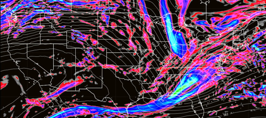
I’ve been watching the timing of the northern and southern stream energies on a lot of model guidance in the past few days. The one trend I have noticed with confidence is that the northern stream is not quick enough to catch the southern stream. Does this mean a storm won’t happen? No, there will definitely be a deepening low pressure system off the NJ coast this weekend. It’s just that it will be mostly driven from the southern stream energy. Unless the southern stream slows down to interact with the slower northern stream then we can assume mostly southern stream impact.
With that said we likely won’t have a true Arctic cold injection but we will have some cold air around. On the latest guidance basically 925mb (1700ft) and up is all cold enough to support snowfall. The surface is slightly above freezing during weekend precipitation but with a deepening low and heavy precipitation rates, the surface would crash to freezing fairly quickly. Therfore whether or not it gets cold enough to support snow accumulation will be dependent on the dynamics of the deepening low and precipitation rates bringing the colder air down with it.
Since the southern stream will be mostly in charge of our storm and is faster we are now looking at Saturday impact not Sunday impact. The European and NAM are suggesting a light snow event for this period where the air is cold enough. The Euro favors NNJ. The NAM favors SNJ.
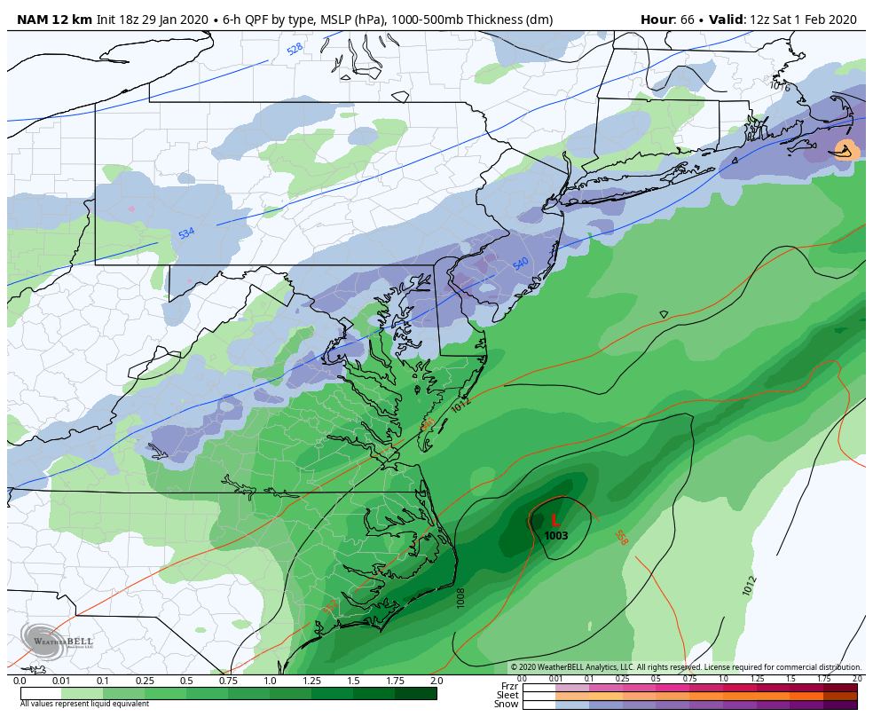
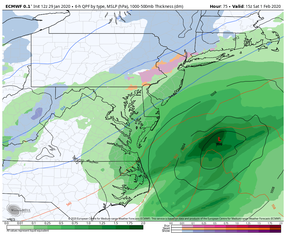
The GFS and Canadian have been close grazes. None of these solutions present a power winter storm system but also none of them are dismissing the threat completely out to sea. We’re now 4-5 days away from this system with a lot of volatility and lack of confidence. That tells me the current status quo seen in the above models still have time to trend either colder/snowier or warmer/wetter. We’re just going to have to be patient and watch the model guidance and live observations evolve. I wish I had more for you at this time but I don’t. I’m going to continue watching this aggressively tonight and will report again tomorrow after the 12z model suite like today.
In English: Still watching for a storm to bring a mix of snow/rain to NJ this weekend. Timing has trended towards more of a Saturday event than Sunday and we’re probably only looking at a light-to-moderate snow event at most for whoever gets the jackpot swath of snow. I need another 24 hours to make any concrete assumptions. A far miss out to sea is becoming less likely through. We’re likely on the hook for at least a graze…but the outermost NW side of the precipitation shield would be the coldest area of the storm. The models are simply showing a solution too close to something bigger to take it off the table at this point. Have a great night and please be safe! JC
Download the new free Weather NJ mobile app on Apple and/or Android. It’s the easiest way to never miss Weather NJ content. Our premium services go even further above and beyond at the hyper-local level. Looking for industrial-caliber long-range forecasting data that I personally recommend? Check out WeatherTrends360! Visit the Weather NJ Kaboom Shop for hoodies, tees and infant onesies.
Jonathan Carr (JC) is the founder and sole operator of Weather NJ, New Jersey’s largest independent weather reporting agency. Since 2010, Jonathan has provided weather safety discussion and forecasting services for New Jersey and surrounding areas through the web and social media. Originally branded as Severe NJ Weather (before 2014), Weather NJ is proud to bring you accurate and responsible forecast discussion ahead of high-stakes weather scenarios that impact this great garden state of ours. All Weather. All New Jersey.™ Be safe! JC


LOCAL FORECAST | INTERACTIVE RADAR | LATEST NJ WEATHER ALERTS | WEDDING FORECAST| PRIVACY POLICY
© Copyright 2025 Weather NJ LLC. All Rights Reserved.
Some information that can be found on our website is provided by a private weather station and is not an officially recognized station for weather reporting. Though we always strive to achieve accurate reporting for our own use, it is important that you do NOT depend on the data provided here for any purpose.
