

Jan 30: Major Winter Storm Approaching
Discussion: I’m going to break this winter storm into three phases of expectations.
Phase I: Precipitation is currently approaching from the W. It’s just now getting into the Kentucky/Indiana/Ohio area and starting to build the initial snow thump expected for SNJ on Sunday. We’re looking at snow starting as early as noon tomorrow (Sunday) maybe even earlier for extreme SWNJ.
Snow should then build and spread into more of CNJ/NNJ by late Sunday night/Monday AM and that will complete the first phase of this winter storm…the front-end overrunning thump. By that point, most of NJ S of I-195 should have a widespread 3-6 inch snowfall, possibly greater. Less for areas N of I-195 who are just starting. A small wildcard exists for a heavier snow thump if snow ratios are slightly higher than 10:1 from wet bulb saturated temps. If it’s snowing in the 20-25F range then amounts would be higher. If we’re closer to 32F then 10:1 ratios would apply.
Phase II: This second phase of this system will revolve around the period where a snow/rain line pushes in from the SE and then retreats back out to sea where it came from. We currently expect this to be from early Monday AM through mid-to-late Monday PM. This is when the actual secondary coastal low will set up and generate heavy onshore flow for the ECNJ/SENJ coast. With a very cold current air mass in place, available cold from upper-levels, high expected precipitation rates, annual low ocean temperatures, and cold air injection from the north high, we think the snow/rain line will eventually hit a cold wall and not allow it to extend as far NW as a warmer setup. But for however far that makes it inland and for much of Monday, those areas (at least SENJ) should changeover to a mix or all rain. Areas N and W of that snow/rain line will remain snow and continue to accumulate. The maximum NW extent currently looks like an I-95 kiss before retreating. But again, we are leaning towards somewhere SE of that. This second phase will contain the highest coastal winds and greatest coastal flooding potential. Since the NYC and Monmouth/Ocean County areas are closer to the ocean and have a better chance at remaining all snow, said areas would be most favorable for obtaining blizzard criteria (blinding snow + 3 hours of 35mph sustained winds). Once the snow/rain line retreats to the SE with the low setting up to our E (watch for winds to change from E to NE to N/NE), phase two will complete and all of NJ will return to snowfall.
Phase III: The third and final phase will be the backside of the precipitation shield as the storm is pulling away. This should be anywhere from late Monday PM through much of Tuesday. For this phase we see all snow (no rain) however model guidance has been insistent on lighter/broken precipitation. In theory the models are likely factoring the low trying to move E away from us. However IMO I would expect a snowier finish from a 988mb just E of AC/Cape May. With that said, this is the other wildcard I am watching. Not probable enough to forecast but interesting enough to watch. A deformation zone could easily occur with the cold conveyor belt driving in from the N/NE.
Winds and Coastal Flooding: Aside from the travel disruption and government/school closures from snow, there should be wind-related power-outages especially when winds start to peak late Sunday night through Monday. We’re probably talking sustained winds along the immediate coast of 30-35mph with gusts of 50-60mph. Barrier island locations along ECNJ/SENJ should not slouch on coastal flooding potential. The 2-3 high tides of concern are both Monday high tides (near noon and midnight) and the first Tuesday high tide (near noon). After that, winds should blow the surge back out to sea. Only west-facing bay areas/barrier islands would be subject to the tidal exodus high tide Tuesday night.
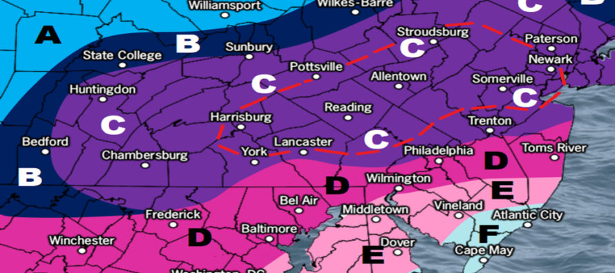
With all points above considered, here’s our forecast snow map for the entire event (Sunday-Tuesday). We’ll have time to make one more revision tomorrow morning if needed upon reviewing overnight/morning model guidance and live observations:
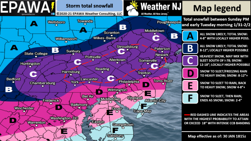
Zones C and F are the most confident. Zones D and E are the least confident since they are based on how far the snow/rain line pushes in. Zone D and some of zone E could behave like zone C if the overall solution is colder (snow/rain line hits cold wall). Zone E and some of zone D could behave like zone F if the snow rain line is more aggressive and makes it closer to 95/NJTP. Just want to state the uncertainties and and range of probabilities. As far as zone C and the dotted area…yes amounts could exceed the legend range however we are not counting on it as a forecast.
In English: Snow is approaching from the W and could begin falling in SNJ as early as late Sunday morning/Sunday afternoon. KABOOM for much of NNJ/CNJ (mostly a Monday-Tuesday thing). Significant/plowable snow for SNJ (mostly Sunday into Monday AM) even though the middle of the storm changes to rain for at least some of SENJ maybe all the way to the Turnpike. We’ll only know that during the event. SNJ should go back to snow to finish on Tuesday. High winds along the coast should lead to power outages. Lesser winds inland. Coastal flooding problems for immediate coastal areas of ECNJ/SENJ. Buckle up folks and be safe! JC
Our premium services go even further above and beyond at the hyper-local level. Get your Weather NJ merch on at the KABOOM shop!
Jonathan Carr (JC) is the founder and sole operator of Weather NJ, New Jersey’s largest independent weather reporting agency. Since 2010, Jonathan has provided weather safety discussion and forecasting services for New Jersey and surrounding areas through the web and social media. Originally branded as Severe NJ Weather (before 2014), Weather NJ is proud to bring you accurate and responsible forecast discussion ahead of high-stakes weather scenarios that impact this great garden state of ours. All Weather. All New Jersey.™ Be safe! JC


LOCAL FORECAST | INTERACTIVE RADAR | LATEST NJ WEATHER ALERTS | WEDDING FORECAST| PRIVACY POLICY
© Copyright 2026 Weather NJ LLC. All Rights Reserved.
Some information that can be found on our website is provided by a private weather station and is not an officially recognized station for weather reporting. Though we always strive to achieve accurate reporting for our own use, it is important that you do NOT depend on the data provided here for any purpose.
