

Jan 31: Winter Storm Update – 2nd Call Map
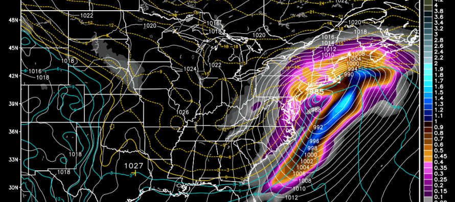
Model guidance trended northward last night and today. Instead of a weaker ~1004mb low passing over the VA/NC border, a ~995mb is modeled to pass over the Delmarva Peninsula and SNJ. The low is simply northward because it’s slightly amped than what guidance was showing prior to the trend. The stronger the low, the more N/NW it will track. What’s crazy is that the northward trend might not be finished.
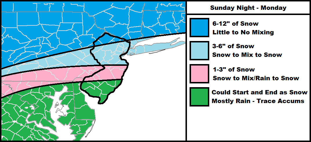
The low will hurl warm/moist air northward into a very cold air mass reinforced by high pressure. The surface will still be cold while the warmer air invades at higher levels. This is a recipe for sleet and/or freezing rain. I think this will be more of an issue for CNJ than NNJ or SNJ. We’re really going to have to watch CNJ, especially between I-195 and I-80. It really could go either way. The darker blue area to the north has the best chance at staying all snow. SNJ and SENJ might see some front end snow but will go over to cold rain for most of the event. There’s still some time for more trending which is why my final call and snow map wont be posted until tomorrow evening just prior to the Super Bowl.
In English: The map is pretty straight forward. This is not a black-and-white (rain or snow) system. All wintry precipitation types are on the table including snow, sleet, freezing rain, and rain. There will likely be a period of snow to start tomorrow night…then the mixing/rain for CNJ/SNJ overnight into Monday…and finally a period of snow to end as temperatures crash behind the low on Monday. Final call and snow map will be posted by 6PM tomorrow at which point now-casting will commence. Be safe! JC
Model image used with permission from WeatherBell Analytics.

Jonathan Carr (JC) is the founder and sole operator of Weather NJ, New Jersey’s largest independent weather reporting agency. Since 2010, Jonathan has provided weather safety discussion and forecasting services for New Jersey and surrounding areas through the web and social media. Originally branded as Severe NJ Weather (before 2014), Weather NJ is proud to bring you accurate and responsible forecast discussion ahead of high-stakes weather scenarios that impact this great garden state of ours. All Weather. All New Jersey.™ Be safe! JC


LOCAL FORECAST | INTERACTIVE RADAR | LATEST NJ WEATHER ALERTS | WEDDING FORECAST| PRIVACY POLICY
© Copyright 2026 Weather NJ LLC. All Rights Reserved.
Some information that can be found on our website is provided by a private weather station and is not an officially recognized station for weather reporting. Though we always strive to achieve accurate reporting for our own use, it is important that you do NOT depend on the data provided here for any purpose.
