

Jan 5: Tracking Wintry Storm Signals
Discussion: We have two immediate synoptic signals to track. One is for this Friday-Saturday (Jan 8-9) and the other is for next Tuesday (Jan 12). There’s another Jan 15 but let’s deal with the first two that are now inside the 7-day forecasting period.
A low pressure system will be ejecting into the Atlantic Ocean this Friday morning well to the S of NJ (likely near GA). The low will then try to turn N up the coast but face a block in the form of an E Canadian ridge and 50/50 Upper-Level Low (ULL). Therefore, this one might miss too far to the S/SE which means we would be on the colder side of the storm not the warmer side. Most guidance has this system as a miss to the SE of NJ however a few ensemble members do have it tracking close enough to possibly bring light snow to the SENJ coast on Friday. We’ll have to watch any NW trends in track over the next few days (like we saw with the last few systems). That could quickly bring a coastal snow event back on the table for this Friday. As modeled right now verbatim however it’s a close miss out to sea.
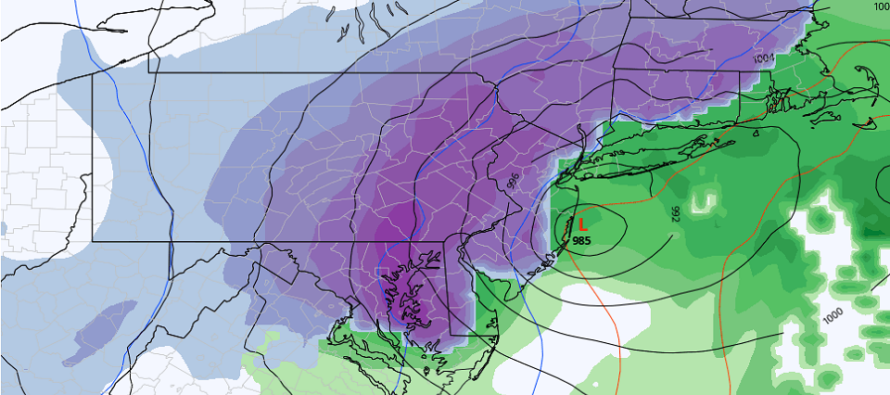
The next signal is Tuesday-Wednesday (Jan 12-13). This one looks similar in general track idea and intensity to this Friday but takes a deeper dive in the C US before trying to come up the coast…a little more meridional. The latest Euro run just hit NJ pretty hard with this one (above cover image). Other models have it a little further SE like this Friday. Another signal far from dismissal but with better likelihood IMO of coming further N up the coast.
Both systems are basically facing flat heights downstream under the block. For these systems to bring snow to NJ, we’ll have to see an increase in heights for the E coast ahead of them. That’s what I’ll be looking for in the upper levels. There’s not much room to go N given the suppression but possibly just enough to bring NJ into a bigger snow game. The Friday system would have to do this sooner than later. We have time for the Tuesday signal. It is possible, however, that both systems could miss just to the S/SE of NJ. Being on the colder and drier side of these system would align with the upcoming expected pattern change. This leads me to the long-range discussion.
The stratospheric Polar Vortex (PV) has split into three daughter vortices. An area of positive stratospheric height anomalies has filled the stratospheric void and is currently expanding over the N Pole. As the stratosphere expands from this Sudden Stratospheric Warming Event (SSWE), the troposphere beneath it collapses. The cold Arctic surface air from the N pole has nowhere to go but the lower latitudes of the N Hemisphere. This entire cycle, from SPV split to mid-latitude cold air arrival can take between 1-2 weeks.
The PV split and SSWE are just the first part of the equation. For the very cold air to spill into the E US instead of the W US or C US, we need to be in an E US trough pattern with blocking. At this point, it appears we’re going to be in one. The teleconnections models are confidently projecting a -NAO, -AO, +PNA, -EPO pattern from about Jan 13-20, possibly beyond. This means E Pacific troughing feeding W US ridging feeding E US troughing jammed up by NE North American ridging.
So to recap, we have live obs polar synoptics and expected jet stream orientations suggesting a very cold dive into below-average temperature anomalies for the Mid-Atlantic US. These colder anomalies should begin hitting the E Great Lakes around Jan 15 and then NJ by Jan 20. At the very least this means it will be cold enough for snow to accumulate for any storm system that forms. Given the active pattern, at least one or two low pressure systems should pass through or near during this colder pattern Jan 15-20+. Possibly some clippers and lake effect streamers. It’s obviously way too soon to track anything specific. For now, I’m focused on the cold air invasion.
In English: Friday-Saturday’s (Jan 8-9) coastal snow storm potential will likely just miss to the SE of NJ. I’ll be watching for any NW trends in storm track but we’re starting to run out of time for that. We’ll likely know by tomorrow (Wednesday) night if it’s going to impact any part of NJ. Next Tuesday-Wednesday (Jan 12-13) is the next signal to watch before a major expected pattern shift. From about Jan 15-20, Arctic air is expected to spill down from the N and linger around for a while. I can’t really speak to specific snow signals in the second half of January but the temperature profile looks well below-average…which at the coldest time of year means very cold air mass. Until that cold air invasion, and between the synoptic storm signals, temperatures should remain slightly above average with uneventful conditions. Let’s see how the signals look tomorrow. Have a great rest of your Tuesday and please be safe! JC
Download the free Weather NJ mobile app on Apple or Android. It’s the easiest way to never miss Weather NJ content. Our premium services go even further above and beyond at the hyper-local level. Get your merch on at the KABOOM shop in time for the holidays.
Jonathan Carr (JC) is the founder and sole operator of Weather NJ, New Jersey’s largest independent weather reporting agency. Since 2010, Jonathan has provided weather safety discussion and forecasting services for New Jersey and surrounding areas through the web and social media. Originally branded as Severe NJ Weather (before 2014), Weather NJ is proud to bring you accurate and responsible forecast discussion ahead of high-stakes weather scenarios that impact this great garden state of ours. All Weather. All New Jersey.™ Be safe! JC


LOCAL FORECAST | INTERACTIVE RADAR | LATEST NJ WEATHER ALERTS | WEDDING FORECAST| PRIVACY POLICY
© Copyright 2026 Weather NJ LLC. All Rights Reserved.
Some information that can be found on our website is provided by a private weather station and is not an officially recognized station for weather reporting. Though we always strive to achieve accurate reporting for our own use, it is important that you do NOT depend on the data provided here for any purpose.
