

Jan 7: Snow Signal Update
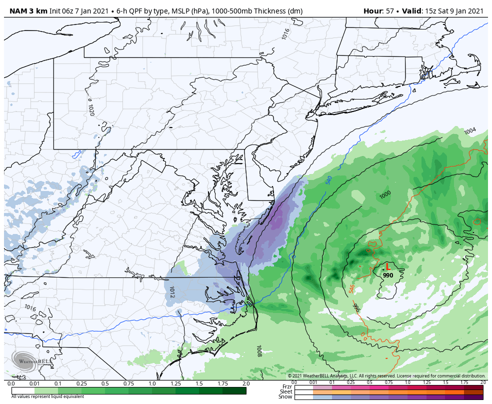
Discussion: This morning’s 6Z NAM run was about as close as the Jan 8-9 (tomorrow-Saturday) storm signal has been modeled over the past few days (see below image).
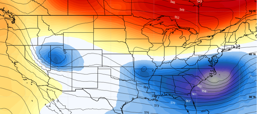
The more recent 12Z model suite has re-affirmed a miss to the S/SE of NJ. Geopotential heights along the east coast are too flat ahead of the system and there’s little room to budge northward with the block created by the ridge and upper low approaching from the N. At this point, there is just a very small chance that the precipitation shield from the storm extends further NW than modeled into parts of extreme SENJ. It would probably only be flurries with little to no accumulation. It will be near-40 during the day on Friday but temperatures will drop below freezing through sunset when the precipitation shield will be closest to NJ. I wouldn’t hold my breath for it but wouldn’t be shocked if it happened. The cover image of this article shows the 500mb height anomalies indicating that upper-level energy is there to intensify the low. But either way, no major weather safety hazards of concern.
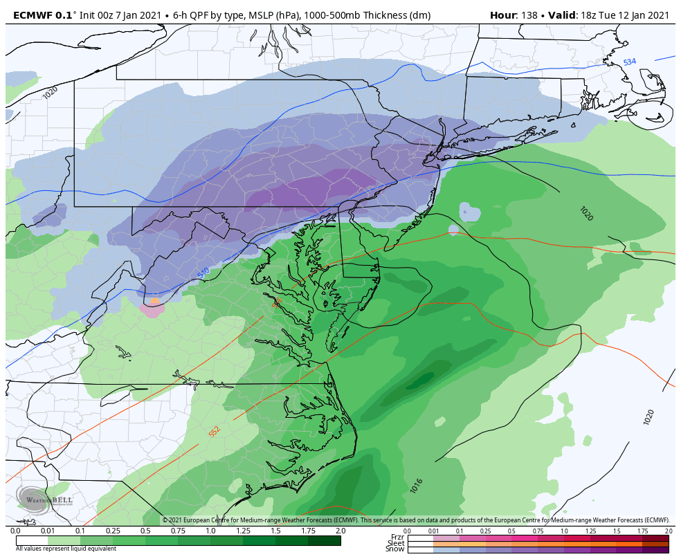
The next synoptic storm signal is for Tuesday-Wednesday, Jan 12-13. The Euro, GFS, and Canadian have all been showing a coastal low pressure system in this time frame of closer proximity to NJ than tomorrow’s signal. There are a handful of shortwaves moving through on two different streams and the models are all over the place about it. When the shortwave phasing is modeled with more interaction, you get snowier solutions like what the Euro has been suggesting yesterday and overnight (see below image).
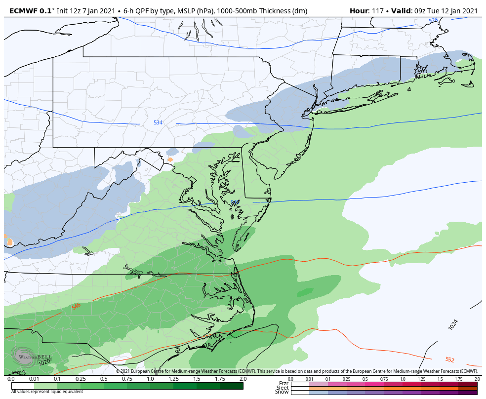
When the shortwaves are not timed for interaction, you get weaker solutions with strung-out lighter precipitation like what the most recent Euro run suggested today (see below image).
By Saturday night the models should have a much better handle on the shortwave timing and interaction which will allow us to start forecasting surface solutions. In the meantime I’ll be tracking it a bit more seriously now that we are 5 days away.
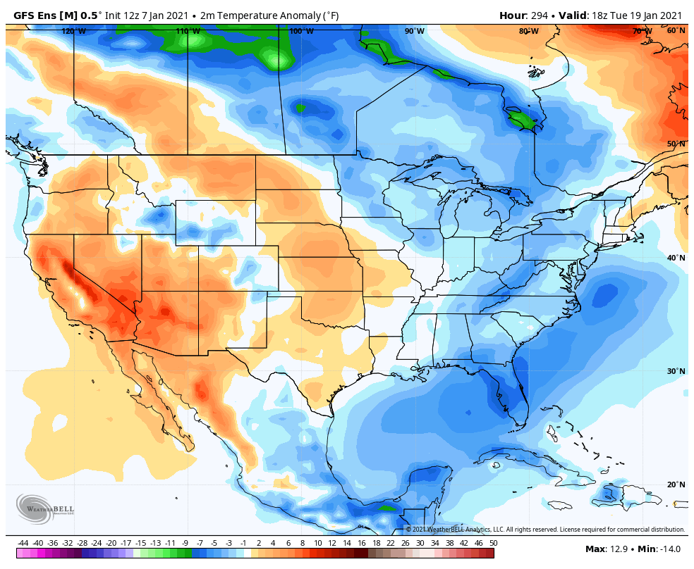
The more confident and larger story remains the Arctic cold air invasion set to arrive about 10 days from now. We’ve been tracking this which began as a stratospheric PV split and sudden warming event over the N pole about a week ago. The stratosphere has expanded over the N Pole, from warming, forcing the troposphere below it to collapse and distribute the planet’s coldest surface air downward into the mid-latitudes. Our favorable E US trough pattern will allow this cold to spill well into the E US. It should start arriving near the Great Lakes around Jan 15 and reach peak cold extension southward by Jan 20. For NJ, it currently looks to arrive around Jan 17. This is a very strong cold signal (surface temperature anomaly) on the GFS ENS, now backed by the Euro ENS (see below image).
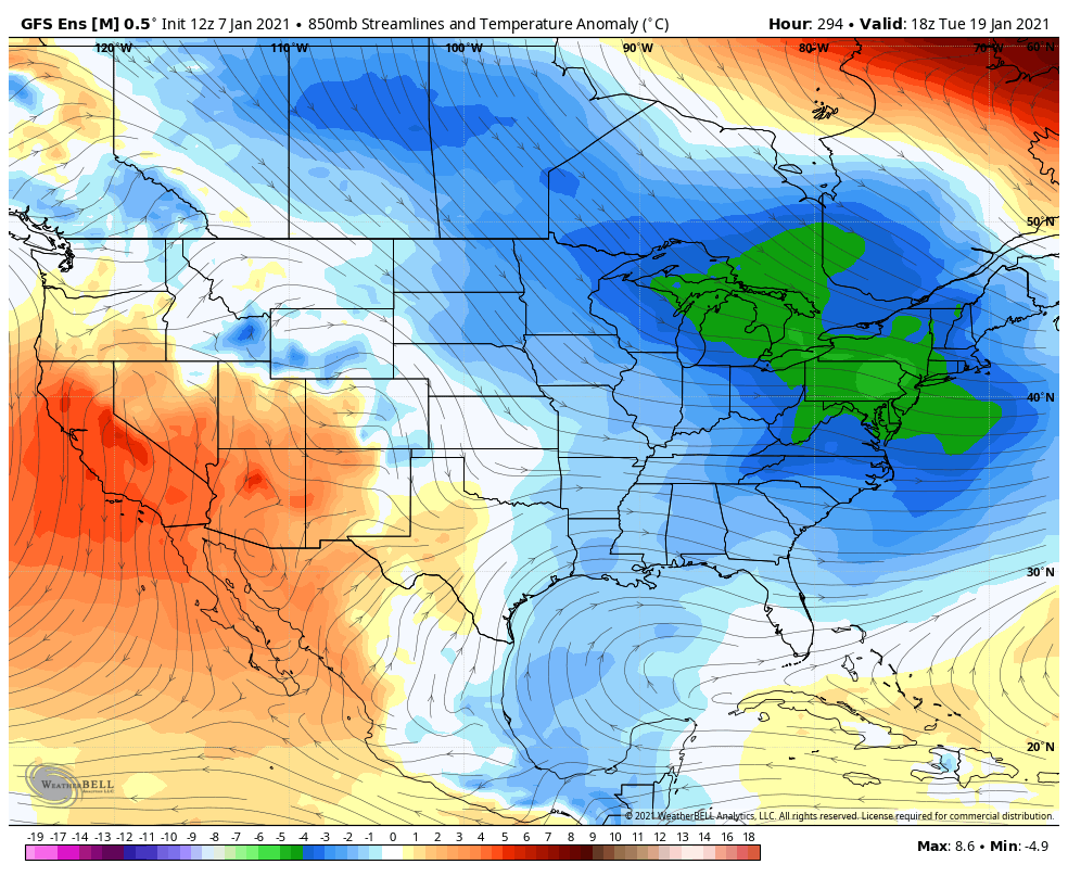
The Arctic cold air mass invasion can be more easily depicted at the 850mb level (see below image).
It will then take some time for this cold to erode as it will not be a transient air mass. NJ is probably looking at a week, maybe longer, where most of the state stays below freezing and overnight temps go into pipe-bursting territory. Record cold? Probably not. But at least 5-10 degrees below average which in January is cold.
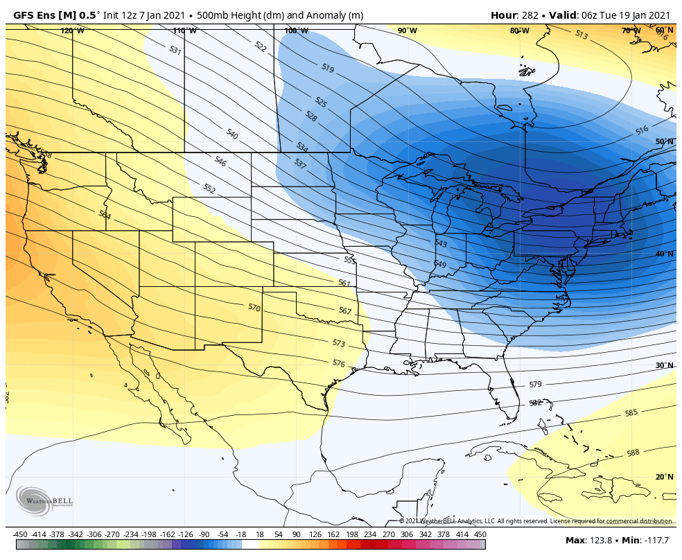
Within the expected cold pattern, from Jan 17-forward, is a very active setup. A very powerful upper-level low that’s infused by a lobe of a PV daughter vort is expected to be nearby in the Jan 17-20 period. The modeled geopotential height anomalies indicate this (see below image).
This means unsettled with periods of precipitation rather than just cold and bone dry. In theory this would mean at least several smaller snow events where it would be absolutely cold enough for every flake to stick. Whether or not something larger is capable of forming is yet TBD but it would be a heck of a setup for it to not happen. With that said, the Jan 17-20 period is the next general signal we are watching beyond the Jan 12-13 one.
By now you should understand that me “tracking a long-range synoptic storm signal” does not guarantee a storm is coming. It means there will most likely be a low somewhere on the east coast but that low is capable of missing to the N or S of NJ. Only when models converge on a consensual NJ-hit solution, in the short-to-mid-range forecasting period, do we then start running with with more of a specific surface solution forecast.
In English: Friday’s system still a miss to the S/SE. Maybe flurries reach the SENJ coast but probably not. Meh. Then tracking Tuesday-Wednesday’s system for more possible snow. ~Jan 17 and beyond looks very cold with the active pattern continuing. The theme of “favorable for winter storm development but nothing big and specific showing yet” generally continues. Right now, Tuesday-Wednesday is our next best shot for snow. Between and around these storm signals (until the Arctic air arrives), conditions should remain slightly above average in temperature. This is still cold because it’s January – highs 35 to 45 and lows 15 to 30 NW to SE). I’ll have the weekend outlook out tomorrow and we’ll revisit the future signals on Saturday. Have a great rest of your Thursday and please be safe! JC
Download the free Weather NJ mobile app on Apple or Android. It’s the easiest way to never miss Weather NJ content. Our premium services go even further above and beyond at the hyper-local level. Get your merch on at the KABOOM shop in time for the holidays.
Jonathan Carr (JC) is the founder and sole operator of Weather NJ, New Jersey’s largest independent weather reporting agency. Since 2010, Jonathan has provided weather safety discussion and forecasting services for New Jersey and surrounding areas through the web and social media. Originally branded as Severe NJ Weather (before 2014), Weather NJ is proud to bring you accurate and responsible forecast discussion ahead of high-stakes weather scenarios that impact this great garden state of ours. All Weather. All New Jersey.™ Be safe! JC


LOCAL FORECAST | INTERACTIVE RADAR | LATEST NJ WEATHER ALERTS | WEDDING FORECAST| PRIVACY POLICY
© Copyright 2026 Weather NJ LLC. All Rights Reserved.
Some information that can be found on our website is provided by a private weather station and is not an officially recognized station for weather reporting. Though we always strive to achieve accurate reporting for our own use, it is important that you do NOT depend on the data provided here for any purpose.
