

Jan 7: Snowfall Approaching
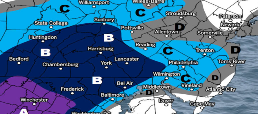
Discussion: Our system has trended towards an expanded field of snowfall. It hasn’t trended towards more snow than yesterday’s expectation just further N into New Jersey. There is going to be a sharp cutoff of precipitation on the N/NW side of this light system. If you are in NNJ, especially NWNJ, you are least favored for any kind of snowfall. If you are in SENJ you are most favored for a warmer rain-to-snow scenario. Areas between stand to see the best chance of accumulations hence the jackpot zone of the snow map.
This is a weak and fast-moving system. It is currently over W NC/SC and should track across the S Delmarva Peninsula this afternoon through evening. It’s already into the 40s in many places today. Temperatures are expected to gradually fall through sunset and into evening hours. The surface temperature profile is still modeled to be marginal (close to but above freezing) during most snowfall. For this reason we believe that a decent amount of snowfall could actually fall but struggle to accumulate especially on paved surfaces. That’s why C-2 is our biggest zone despite 2-4 possibly/actually falling and melting down.
I would like to speak to a small wildcard scenario where parts of SENJ (Ocean and Atlantic Counties) could behave more like zone C instead of A/B. This would be if precipitation rates are high enough to bring colder air down to the surface. If such happens it would be slightly convective in-nature with linear segments of lifting and sinking air (meso bands). Again it would only mean C-2 of accumulation for SENJ instead of C-1 or just a dusting. Either way I still recommend setting the alarms for Wednesday morning.
After this clears out we are pretty cold and windy (wind chills!) Wednesday overnight into Thursday. Then the mild stuff moves in Friday to set up a very mild weekend.
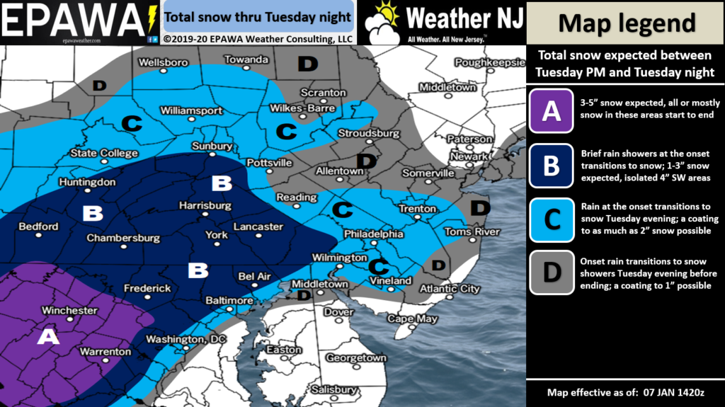
Click here for full resolution snow map!
In English: Rain should approach SWNJ by late-afternoon and spready into CNJ/SNJ by early-evening. Temperatures should gradually fall and change rain to snow from NW to SE during evening hours as the precipitation shield expands to include some of NNJ. NWNJ is least favored for snow via cut-off. SENJ is most favored for a warmer rain/snow mix via marine mass/flow. The I-95 corridor (NJTP) and points immediately SE of such are most favored for the coldest/wintry impacts. The above snow map represents our expectations mostly for natural surfaces. The surface is above freezing. In order for snow to stick to roads we’ll need wildcard meso-banding to bring colder air down…something that is a lower probability but cannot be called until it’s happening. Have a great night and please be safe! JC
Download the new free Weather NJ mobile app on Apple and/or Android. It’s the easiest way to never miss Weather NJ content. Our premium services go even further above and beyond at the hyper-local level. Looking for industrial-caliber long-range forecasting data that I personally recommend? Check out WeatherTrends360! Visit the Weather NJ Kaboom Shop for hoodies, tees and infant onesies.
Jonathan Carr (JC) is the founder and sole operator of Weather NJ, New Jersey’s largest independent weather reporting agency. Since 2010, Jonathan has provided weather safety discussion and forecasting services for New Jersey and surrounding areas through the web and social media. Originally branded as Severe NJ Weather (before 2014), Weather NJ is proud to bring you accurate and responsible forecast discussion ahead of high-stakes weather scenarios that impact this great garden state of ours. All Weather. All New Jersey.™ Be safe! JC


LOCAL FORECAST | INTERACTIVE RADAR | LATEST NJ WEATHER ALERTS | WEDDING FORECAST| PRIVACY POLICY
© Copyright 2026 Weather NJ LLC. All Rights Reserved.
Some information that can be found on our website is provided by a private weather station and is not an officially recognized station for weather reporting. Though we always strive to achieve accurate reporting for our own use, it is important that you do NOT depend on the data provided here for any purpose.
