

Jan 7: Wintry Threat for NNJ Tonight
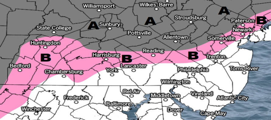
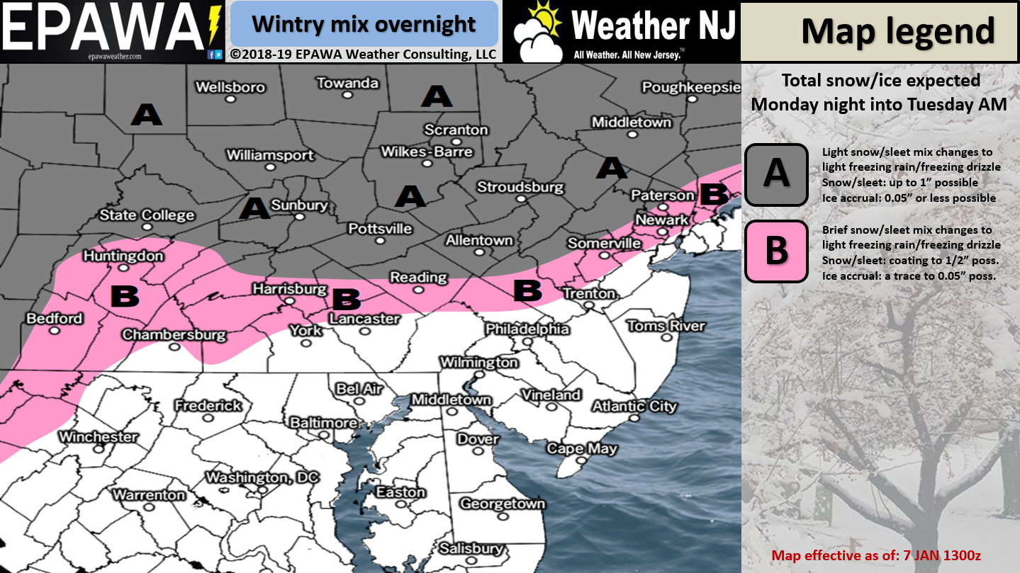

Discussion: It’s no secret that last night was cold and temperatures have struggled to climb today. For the areas of expected wintry impact overnight tonight temperatures have failed to climb above freezing today. For the lower 2/3 of NJ temperatures are currently just over freezing. Therefore we know the ground is cold NW of I-95 and N of I-78 which warrants the NNJ wintry threat. We do have warm air advecting into the region, powered by the upper-level ridge moving in. With that said, NNJ (and parts of WCNJ) should start wintry overnight tonight while the rest of NJ should start and end as mostly all rain. By tomorrow morning all of NJ, including NNJ, should be all rain as precipitation clears by noon.
I’m not seeing much of a snow threat given the warmer upper-level advection over the colder surface. This, IMO, is more of a sleet/freezing rain threat for NNJ. The highest elevations of NWNJ might see more of an initial snow burst but even those areas should go to all rain by morning. So it’s a light snow to ice to rain expected scenario between late tonight/early AM tomorrow and noon tomorrow. When sleet and freezing rain are involved it doesn’t take much to present hazardous travel conditions so please take this into consideration if you have to travel tonight/overnight, especially between midnight and daybreak tomorrow.
Once this clears out tomorrow temperatures should moderate for a mild Tuesday into Wednesday. Starting Wednesday night temperatures should drop substantially and stay “wintry-cold” through the weekend. Support continues to build for late-weekend winter storm impact in New Jersey. Serious tracking will begin Wednesday if data is consensual and matching live atmospheric observations. It’s WAY too early for specific expected accumulation amounts and precise timing. At this point the long-range winter storm signal is holding as we transition into the mid-range forecasting period.
In English: First, here is a high-resolution full-screen version of the above wintry impact map. This wintry threat is for tonight through tomorrow morning and primarily for NNJ (N of I-78 and NW of I-95). Areas in white will likely start and end as rain. To allow for variance, white areas closer to the pink region could briefly start wintry with little-to-no surface impact other than being wet. Also to allow some wildcard variance, let’s allow for up to a few inches in the highest NNJ/NWNJ elevations before changing over. All NNJ areas should finish as rain by noon tomorrow. Watch out for a thin band of precipitation earlier this evening followed by the meat and potatoes of the precipitation occurring during early AM hours tomorrow. We’re then mild tomorrow into Wednesday and cold from Wednesday night through the weekend. The higher impact wintry potential for this Sunday will be discussed in greater detail starting Wednesday. With the expected wintry impacts this week and weekend, it’s not a bad time to download the new free Weather NJ mobile app on Apple and/or Android. Have a great night and please be safe! JC
Jonathan Carr (JC) is the founder and sole operator of Weather NJ, New Jersey’s largest independent weather reporting agency. Since 2010, Jonathan has provided weather safety discussion and forecasting services for New Jersey and surrounding areas through the web and social media. Originally branded as Severe NJ Weather (before 2014), Weather NJ is proud to bring you accurate and responsible forecast discussion ahead of high-stakes weather scenarios that impact this great garden state of ours. All Weather. All New Jersey.™ Be safe! JC


LOCAL FORECAST | INTERACTIVE RADAR | LATEST NJ WEATHER ALERTS | WEDDING FORECAST| PRIVACY POLICY
© Copyright 2026 Weather NJ LLC. All Rights Reserved.
Some information that can be found on our website is provided by a private weather station and is not an officially recognized station for weather reporting. Though we always strive to achieve accurate reporting for our own use, it is important that you do NOT depend on the data provided here for any purpose.
