

January 2020 Outlook

It’s time to harness WeatherTrends360 technology and look at how January 2020 should play out. WeatherTrends360 algorithms are documented with an 84% verification rate and are based on oceanic water cycles, time table series and very complex mathematics. The best takeaway from this data are general trends (cool vs warm, rainy vs dry, etc). I’m always hesitant to forecast specific surface conditions (rainfall amounts, snowfall amounts, winds, etc) beyond the 7 -day forecasting period. But temperature and precipitation trends are what WeatherTrends360 does best with their proprietary mathematical analysis derived from over 150 years of reactive pattern data. For this reason, let’s call this a long-range discussion of reasonable expectations rather than a locked-in long-range forecast.

The following diagram is calculated using WeatherTrends360 proprietary algorithms for New Jersey in general. Please keep in mind that micro-climate influences can vary. NWNJ elevations and SNJ Pine Barrens (away from the ocean), for example, will verify slightly colder than illustrated due to elevation and soil heat exchange. Interior CNJ/SNJ (closer to N Delaware/Philly/Trenton – I-95 corridor into NENJ) slightly warmer than illustrated due to urban heat island effect and several other influencing factors. All areas of NJ however would have similar graph trends and sky conditions. It’s best to let the following graph paint an overall picture (trends) instead of focusing on the low-level details.
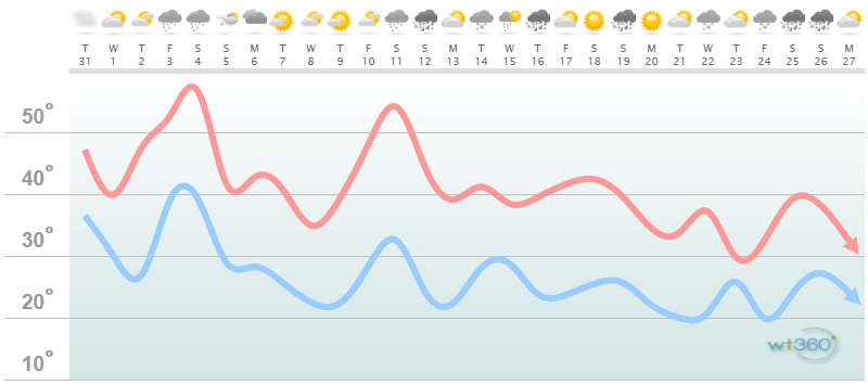
Discussion: The Polar Vortex (PV) remains tightly bound over the north pole (a positive phase of the Arctic Oscillation (AO)). This prevents the true Arctic air from spilling into the E US as we’ve seen during PV outbreaks of prior years. This is the air mass we need over the Great Lakes/SE Canada regions in a loosely-bound negative phase of the AO in order to enter a cold and snowy pattern like winter of 2009-2010…which was nuts. So right now I am not seeing “nuts” cold and snow in at least the first half of January. Instead the true Arctic air should remain tightly-bound over the north pole.
Instead I am seeing a few mild spikes in temperature for the first half of January specifically the periods of Jan 2-4 and Jan 9-12. Between those two milder spikes is a transient cold shot…not of true cold Arctic air but stale cold Canadian air (Jan 6-9). Enough to support snowfall but not a major blizzard. With that said I am monitoring a fast-moving system capable of producing both snow and rain in that Jan 6-9 period…a thread the needle of cold timing system. I’ll report on this later this week if the signal is still showing. We then encounter the second milder spike mentioned above and then it’s back to winter business January 13-forward.
Some indicators are suggesting PV displacement by mid-to-end of January which could set the stage for a colder and snowy end of January into February. This relies on warmer air invading the stratospheric vortex over the north pole by mid-January with colder surface propagation to the E US shortly after.
In general the upper-level pattern dictated by the Pacific Ocean (positive phase of Eastern Pacific Oscillation (EPO) and negative phase of Pacific North American (PNA) are unfavorable for large E US snow events. An upper-level Gulf of Alaska low is always a warm sign for the E US downstream as it typically produces counter-acting ridging. This pattern should temporarily break for the Jan 6-9 period but resume for Jan 9-12. After that we should see some blocking over the Greenland region (a negative phase of the North American Oscillation (NAO)) which should in-theory back the jet stream up into a -EPO +PNA -NAO -AO pattern…a favorable for cold and snow pattern.
So in summary the PV status remains unfavorable for any prolonged Arctic outbreaks of cold and snow. The Pacific jet pattern remains unfavorable for any large thread-the-needle snow events. This combined status should last through at least January 13 possibly out to January 20. Until then the snow lovers will likely need patience and the snow haters will rejoice. The entire winter is far from cancelled though. That’s simply crapping on the carpet of atmospheric science.

In English: Snow showers and squalls are possible later today-tonight (Tuesday – New Years Eve) with little-to-no accumulation likely. Another system I’m tracking is capable of producing plowable but not crippling snow in the Jan 6-9 period. Other than that the first half to two-thirds of January should feature mostly above-average temperatures and below-average snowfall. Any cold periods for the first few weeks of January should be transient with low chances of big snow. The second-half to last-third of January could feature a colder and snowier pattern once the warmer and milder atmospheric drivers clear out of the E Pacific and North America global regions. I’ll be tracking any disturbances whether wintry or not every 7 day forecasting period at a time. Everyone have a happy new year and please be safe! JC
Jonathan Carr (JC) is the founder and sole operator of Weather NJ, New Jersey’s largest independent weather reporting agency. Since 2010, Jonathan has provided weather safety discussion and forecasting services for New Jersey and surrounding areas through the web and social media. Originally branded as Severe NJ Weather (before 2014), Weather NJ is proud to bring you accurate and responsible forecast discussion ahead of high-stakes weather scenarios that impact this great garden state of ours. All Weather. All New Jersey.™ Be safe! JC


LOCAL FORECAST | INTERACTIVE RADAR | LATEST NJ WEATHER ALERTS | WEDDING FORECAST| PRIVACY POLICY
© Copyright 2026 Weather NJ LLC. All Rights Reserved.
Some information that can be found on our website is provided by a private weather station and is not an officially recognized station for weather reporting. Though we always strive to achieve accurate reporting for our own use, it is important that you do NOT depend on the data provided here for any purpose.
