

January Thaw to Conclude this Week

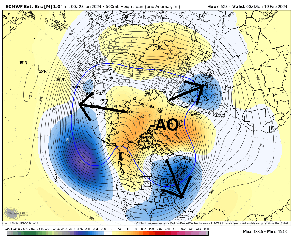
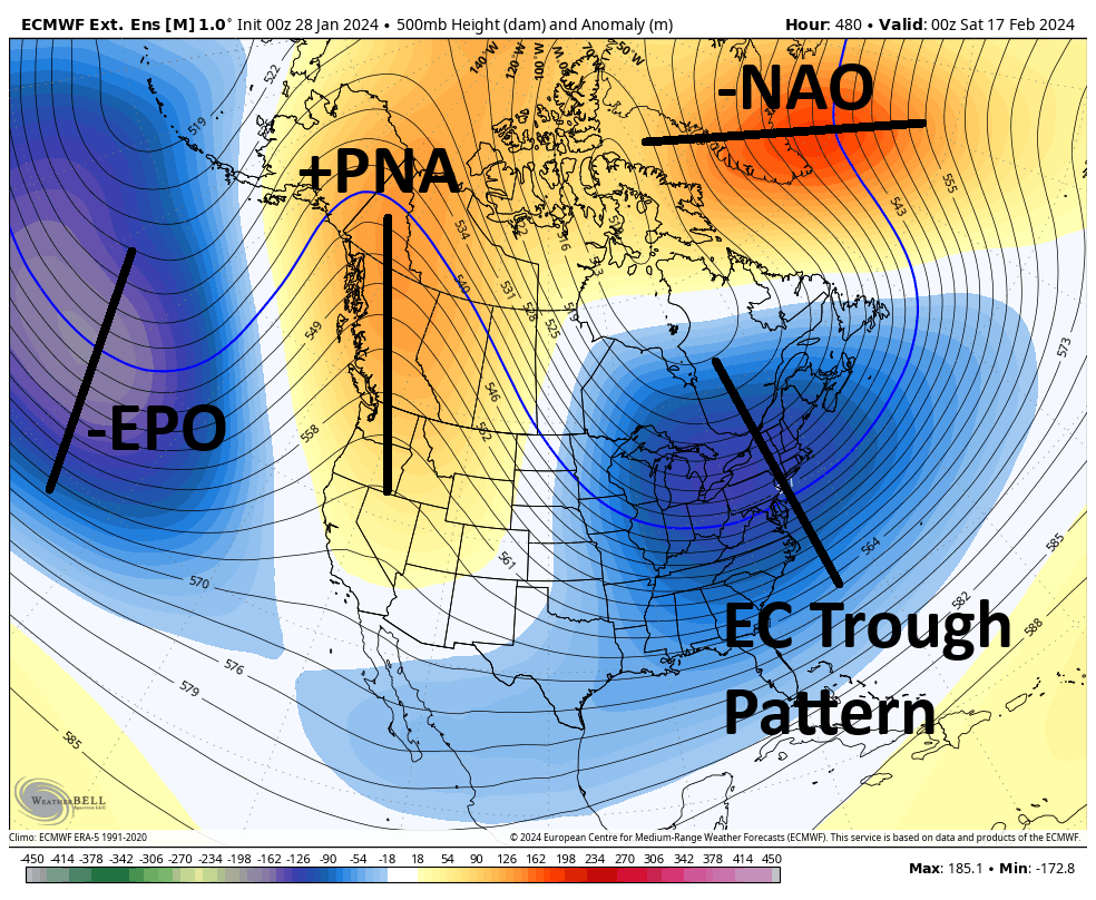
Discussion: Our weak thread-the-needle system has departed, leaving NNJ only with a graze of mixed wintry precipitation and under temporary N/NW flow. This will produce a colder night tonight (Monday night) than what we’ve gotten used to for the past week or so but then we moderate for the rest of this week as the January thaw concludes. A system dives southward out of Canada tomorrow (Tuesday), to the W of NJ, and then pushes eastward out to sea by Thursday beneath NJ. When the low is closest to NJ (Tuesday night/Wednesday morning), snow/rain showers are possible but nothing that’s going to accumulate to much. The biggest safety threat there is wet roads freezing overnight while temps are briefly below freezing (away from the ocean) until sunrise. Wednesday through Friday morning then looks mundane and slightly above average in temperatures. We’ll then see an upper-level shortwave cross the N Mid-Atlantic US and catch the ocean storm, ultimately bottoming out a trough for the NW Atlantic Ocean. NJ will be on the W side of the trough from Friday through the weekend into early next week. The W side of the trough means cold/dry air flow from the NW. With that said, expect a cold front Friday that takes us back to a wintry feel but sets up a cold and dry weekend. The Feb 3-5 storm signal looks to be suppressed to the S of the trough that sets up this weekend. I will report accordingly if that storm signal comes up the coast more. For now, it looks like a SE US hit with maybe some snow for the interior S Mid-Atlantic. I am looking forward to February 12/13 and beyond as a favorable pattern sets up for east coast snowstorm development. The MJO is expected to move into phase 8. Greenland blocking (-NAO), spilling Arctic air (-AO), A W US ridge (+PNA), and E Pacific trough (-EPO) are all also expected now on multiple long-range pattern analysis models (Euro weeklies, CFS, and most recently GFS ensembles). For a snow lover, it’s honestly NSFW material…
Monday (Jan 29) high temperatures have maxed a few degrees on either side of 40. Skies have increased in cloud coverage but should clear some overnight. Winds are light out of the N/NW. Overnight lows should fall to the 20-30 range from NNJ elevations to SNJ coasts.
Tuesday (Jan 30) high temperatures should range from 35-40 from NNJ elevations to SNJ coasts. Skies should be mostly cloudy. Light rain, freezing drizzle, or even some snow flurries/showers are possible for evening-overnight with little-to-no accumulation likely. Overnight lows should range from 25-35 from NNJ elevations to SNJ coasts which would naturally create a line of freezing along the surface near or just SE of I-95.
Wednesday (Jan 31) high temperatures should reach the low-40s for most NJ locations. Skies should be mixed with more clouds than sun. Watch out for any slick spots away from the ocean during early/AM hours from the expected light shower activity. Snow accumulation is unlikely, but ice is very likely on any untreated wet surface until temps rise back above 32. Otherwise, winds will be light out of the S/SW and overnight lows should fall to the 30-35 range from NNJ elevations to SNJ coasts.
Thursday (Feb 1) high temperatures should reach the mid-to-upper 40s. Wouldn’t be surprised to see 50 in some spots away from the ocean in CNJ/SNJ. The mildest day of the week and one of the last before the colder pattern begins reloading. Skies should be mixed with sun and clouds. Winds should be light out of the SW. Overnight lows should range from 35-40 from NNJ elevations to SNJ coasts.
Friday (Feb 2) high temperatures should reach the low-to-mid 40s but right before a cold front pushes through. It might be one of those days where high temps are met in the AM prior to a mid-day cold frontal passage. We’ll see. Can’t rule out a few rain/snow showers on either side of the cold front though the front looks mostly dry. Little-to-no snow accumulation likely. Winds should be light-to-breezy our of the W/SW ahead of the cold front and light-to-breezy out of the NW behind the cold front. Will have a better idea of cold front timing in a few days. Overnight lows should then range from teens to 20s from NNJ elevations to SNJ coasts.
An early look at the weekend indicates cold and dry conditions. Afternoon highs stuck in the 30s and overnight lows down into the teens/20s. The Feb 3-5 storm signal is showing strongest for the SE US and possibly S Mid-Atlantic US. It is currently modeled to miss NJ to the S and SE but I will monitor any northward trends up the coast should they develop. Otherwise, it should be an uneventful stretch into the February 12/13-forward period where a pattern is expected to develop that is favorable for Mid-Atlantic US snowstorm development. A thread-the-needle system can always try to develop but I am currently not seeing any. I have high hopes for the second half of February, possibly into early March. Have a great rest of your Monday and please be safe! JC
Premium Services
KABOOM Club offers inside info forecast discussion, your questions answered, and early storm impact maps (ahead of the public). At a buck per month, it’s an extremely feasible way to show support.
My Pocket Meteorologist (MPM), in partnership with EPAWA Weather Consulting, offers professional/commercial interests, whose businesses depend on outdoor weather conditions (snow plowing, landscaping, construction, etc.), with hyper-local text message alerts/forecasts and access to the MPM premium forum—the most comprehensive and technical forecast discussion available for PA and NJ.
Get your KABOOM Inside Out Pajamas and more at the new KABOOM Shop!
Jonathan Carr (JC) is the founder and sole operator of Weather NJ, New Jersey’s largest independent weather reporting agency. Since 2010, Jonathan has provided weather safety discussion and forecasting services for New Jersey and surrounding areas through the web and social media. Originally branded as Severe NJ Weather (before 2014), Weather NJ is proud to bring you accurate and responsible forecast discussion ahead of high-stakes weather scenarios that impact this great garden state of ours. All Weather. All New Jersey.™ Be safe! JC


LOCAL FORECAST | INTERACTIVE RADAR | LATEST NJ WEATHER ALERTS | WEDDING FORECAST| PRIVACY POLICY
© Copyright 2026 Weather NJ LLC. All Rights Reserved.
Some information that can be found on our website is provided by a private weather station and is not an officially recognized station for weather reporting. Though we always strive to achieve accurate reporting for our own use, it is important that you do NOT depend on the data provided here for any purpose.
