

July 13: Ring of Fire Pattern Detected
The upper-levels should evolve into the classic “ring of fire” pattern to close out July. Here’s what that means for the Mid-Atlantic US…
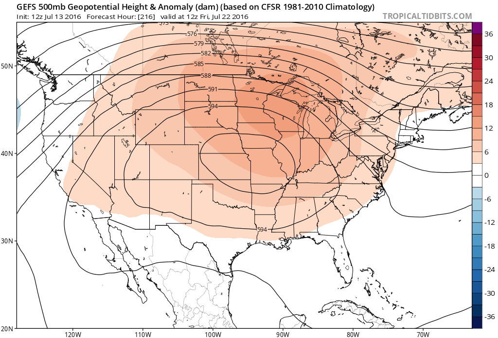
A massive ridge of higher 500mb heights is modeled to form over the Mid-West US starting next week. I’m seeing 500mb heights of almost 600dm (almost 19.5k ft), centralized over ~Kansas for a prolonged period of time. This tells us a lot about the upper-level pattern which ultimately propagates down to the surface.
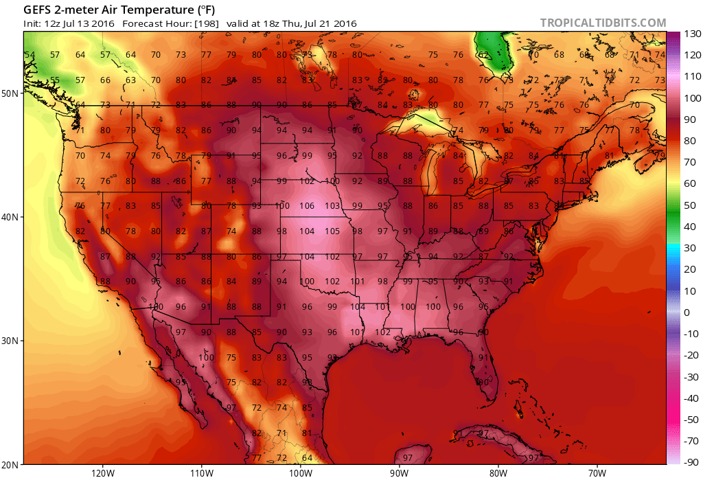
First, let’s discuss temperatures. We’re beating in a natural July summer rhythm: Dry 80s gradually turn into humid 90s…cold front moves through…rinse wash repeat. Pretty average conditions IMO. We’ve had some hot and humid days away from the ocean with heat indices around 100 but that’s far from record breaking stuff like actual temps of 100 and heat indices of 110+
It looks like we’re going to stay this way due to the upper-level pattern setting up. Because the higher 500mb heights are modeled over the Mid-West, they will likely see the highest concentration of excessive heat. We’ll still be warm/hot but not OMG (Usher song) hot like the Mid-West US should be. Here’s an example of surface temperatures for next Thursday to illustrate such (12Z GEFS):
Above the core excessive heat in the Midwest US will be the vertically expanded lower atmosphere, hence the higher height of the 500mb pressure altitude. The 250mb jet will flow around the north side of this area in clockwise motion, creating the ring of fire pattern. This aims the upper-level jet between the Mid-Atlantic and Northeast US regions. Here’s the latest 500mb guidance for next Friday illustrating the ring of fire pattern:
Here’s the same time-frame showing 250mb steering currents:
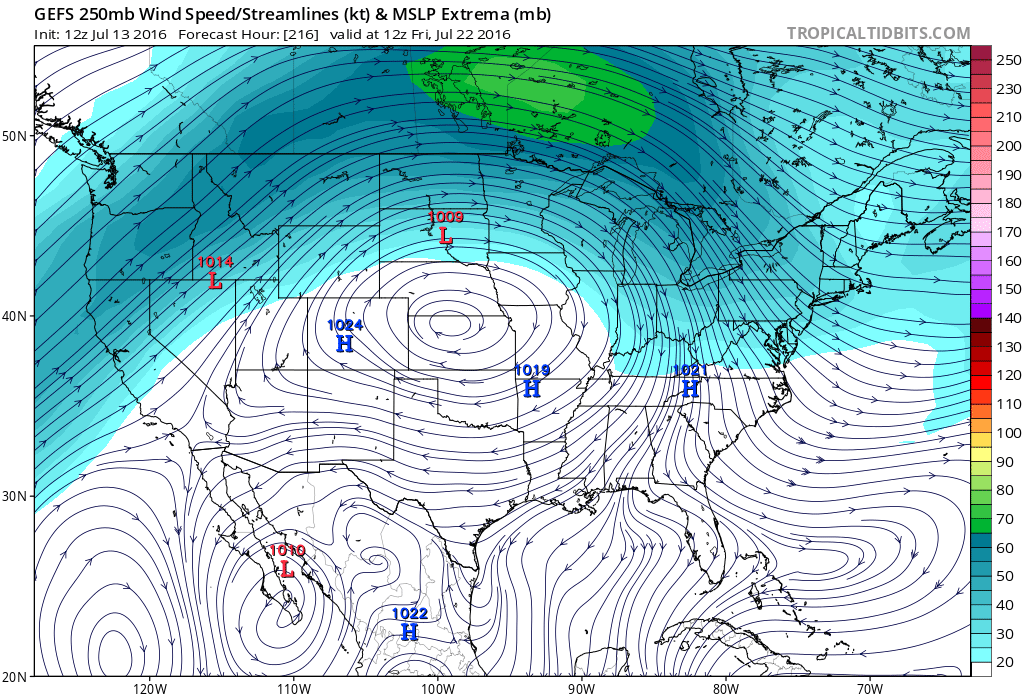
Any storm systems (mesoscale convective systems and/or complexes) that form in the more destabilized region to the W/NW therefore have upper-level support for reaching the coast. Right now, it’s impossible to say when such a system would move through. The main point I’m trying to get across is that the setup is there for it to happen. We’ll have to wait until at least Sunday’s model guidance, if not until early next week, to begin narrowing in on potential mesoscale events.

In English: We’re still looking at unsettled weather heading into the weekend with heat and humidity building a bit more each day. Next week, we should begin transitioning into a ring of fire pattern that should last for most of the rest of July. This means the hottest weather should stay in the Midwest US. We will still see average summer temperatures but are subject to stormier activity from our W/NW. Let’s revisit this early next week. Have a nice night and be safe! JC
I took the cover image last year. It’s a long exposure technique known as light painting.
Jonathan Carr (JC) is the founder and sole operator of Weather NJ, New Jersey’s largest independent weather reporting agency. Since 2010, Jonathan has provided weather safety discussion and forecasting services for New Jersey and surrounding areas through the web and social media. Originally branded as Severe NJ Weather (before 2014), Weather NJ is proud to bring you accurate and responsible forecast discussion ahead of high-stakes weather scenarios that impact this great garden state of ours. All Weather. All New Jersey.™ Be safe! JC


LOCAL FORECAST | INTERACTIVE RADAR | LATEST NJ WEATHER ALERTS | WEDDING FORECAST| PRIVACY POLICY
© Copyright 2026 Weather NJ LLC. All Rights Reserved.
Some information that can be found on our website is provided by a private weather station and is not an officially recognized station for weather reporting. Though we always strive to achieve accurate reporting for our own use, it is important that you do NOT depend on the data provided here for any purpose.
