

July 14: Thunderstorm Update
A decent amount of precipitation fell today (for most not all) with the warm front-driven showers and thunderstorms that occurred earlier. This positioned New Jersey in the warm sector of the general synoptic system currently governing the pattern. Diurnal instability is still existent. You can almost feel it with dew points still in the lower-70s. That will fade with the loss of sun and render the general environment somewhat stabilized for approaching storms to our west. The cold front will eventually move through by tomorrow but until that happens, we’re still on the hook for isolated-to-scattered showers and thunderstorms capable of producing flash flooding and strong-to-severe winds.
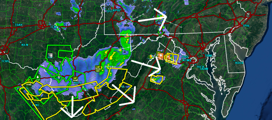
I generally believe that these approaching storms, currently moving through CPA/WV/WMD, will weaken as they move through our region. There simply won’t be enough up-drafting energy to maintain severe-level convection, especially once they move into less CAPE (Convective Available Potential Energy). Also, wind shear is almost non-existent. High PWAT values do tell me that heavy downpours are still possible with “some” lightning and at least moderate wind gusts wherever the storms form. Most likely, these storms will exhaust themselves before even reaching the Delaware River but just in case they hold, allow for the possibility of showers and thunderstorms tonight and overnight.
In English: Expect a warm and humid night with showers and thunderstorms possible, especially during early AM hours. One more set of storm chances tomorrow afternoon and then we’re home free for a few dry and comfortable days heading into the weekend. Be safe! JC
Jonathan Carr (JC) is the founder and sole operator of Weather NJ, New Jersey’s largest independent weather reporting agency. Since 2010, Jonathan has provided weather safety discussion and forecasting services for New Jersey and surrounding areas through the web and social media. Originally branded as Severe NJ Weather (before 2014), Weather NJ is proud to bring you accurate and responsible forecast discussion ahead of high-stakes weather scenarios that impact this great garden state of ours. All Weather. All New Jersey.™ Be safe! JC


LOCAL FORECAST | INTERACTIVE RADAR | LATEST NJ WEATHER ALERTS | WEDDING FORECAST| PRIVACY POLICY
© Copyright 2026 Weather NJ LLC. All Rights Reserved.
Some information that can be found on our website is provided by a private weather station and is not an officially recognized station for weather reporting. Though we always strive to achieve accurate reporting for our own use, it is important that you do NOT depend on the data provided here for any purpose.
