

July 15: Damaging Storms Coming!
Is everyone ready for another round of potentially damaging storms tonight? As I mentioned previously, this is a slow invasion of an unseasonably cool air mass pushing into a warm and humid air mass. The process started yesterday and will fully push through by tomorrow morning. With that being said, the stormiest region will be right along the boundary of both air masses. This is where the upper winds are highest which could be brought down to the surface at any time. In most cases tonight these winds should be straight line. As soon as 58mph gusts are measured, the National Weather Service will trigger a Severe Thunderstorm Warning. I’d expect isolated cases of such with most of New Jersey dealing with just moderate to strong winds. We can’t rule out rotation either, as we saw last night.
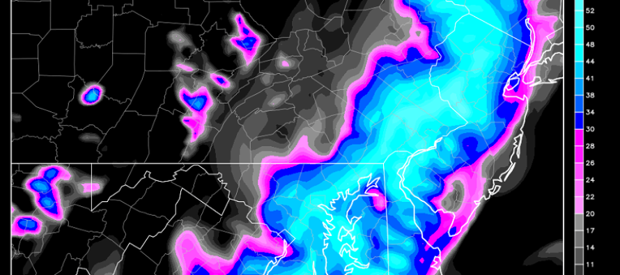
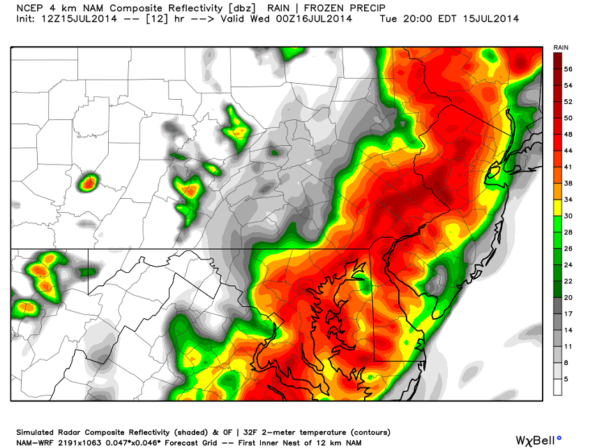
1-3 inches of rain are possible tonight as indicated by the heavy precipitation on short range guidance. This is the high resolution 4km NAM model showing precipitation intensity around 8PM this evening:
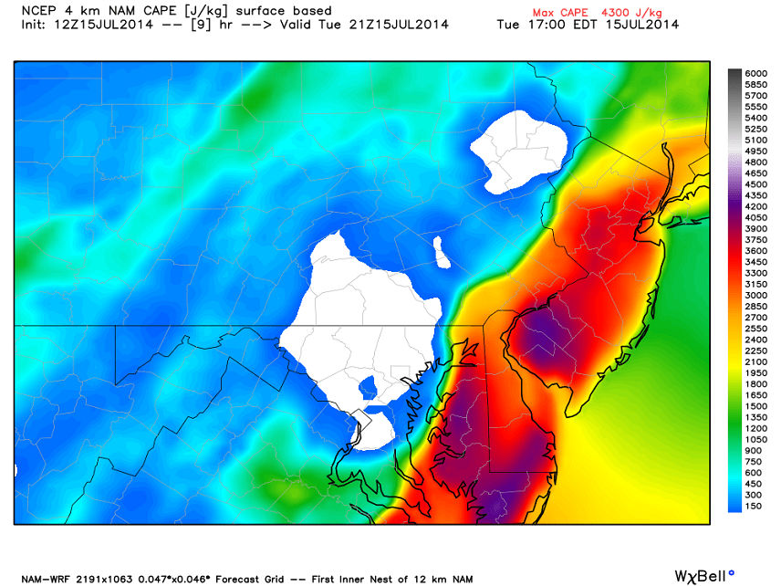
As far as hail and lightning go, that will depend on how much instability develops ahead of the frontal passage—and that will depend on how much solar energy can reach the surface. Clear skies into the afternoon will mean enhanced instability while cloud cover will hinder such. If the instability is higher then cloud tops will spike and produce frequent lightning and isolated instances of hail. If not, then expect tonight to be a rain and wind show. I’ll keep an eye on instability throughout the day but here’s what the NAM says regarding surface CAPE (Convective Available Potential Energy) for 5PM today:
In English: So all ingredients are on the table for severe weather. We’ve got decent upper level winds, instability, and a trigger (the cold front moving through). This leads me to believe that tonight will be a repeat of last night for the general regio. Expect strong-to-severe winds, heavy rainfall, frequent lightning, and possibly hail. Coastal regions should expect storm energy like this to fizzle 9 out of 10 times but there’s always that one time. It all clears by noon tomorrow if not earlier. Then we can take comfort in that cool air mass that caused all this mess. Be safe! JC
Jonathan Carr (JC) is the founder and sole operator of Weather NJ, New Jersey’s largest independent weather reporting agency. Since 2010, Jonathan has provided weather safety discussion and forecasting services for New Jersey and surrounding areas through the web and social media. Originally branded as Severe NJ Weather (before 2014), Weather NJ is proud to bring you accurate and responsible forecast discussion ahead of high-stakes weather scenarios that impact this great garden state of ours. All Weather. All New Jersey.™ Be safe! JC


LOCAL FORECAST | INTERACTIVE RADAR | LATEST NJ WEATHER ALERTS | WEDDING FORECAST| PRIVACY POLICY
© Copyright 2026 Weather NJ LLC. All Rights Reserved.
Some information that can be found on our website is provided by a private weather station and is not an officially recognized station for weather reporting. Though we always strive to achieve accurate reporting for our own use, it is important that you do NOT depend on the data provided here for any purpose.
