

July 2019 Discussion with WeatherTrends360

It’s time to harness WeatherTrends360 technology and look at how the rest of July 2019 should play out. WeatherTrends360 algorithms are documented with an 84% verification rate and are based on oceanic water cycles, time table series and very complex mathematics. The best takeaway from this data are general trends (cool vs warm, rainy vs dry, etc). I’m always hesitant to forecast specific surface conditions (rainfall amounts, snowfall amounts, winds, etc) beyond the 7 -day forecasting period. But temperature and precipitation trends are what WeatherTrends360 does best with their proprietary mathematical analysis derived from over 150 years of reactive pattern data. For this reason, let’s call this a long-range discussion of expectations rather than a locked-in long-range forecast.

The following diagram is calculated for the meat and potatoes of New Jersey in general. Please keep in mind that micro-climate influences can vary. NWNJ elevations and immediate coastal areas, for example, will likely verify slightly cooler than illustrated due to elevation and marine flow influence. Interior CNJ/SNJ (closer to Philly/Trenton) slightly warmer than illustrated. But for most of New Jersey this diagram should suffice for the general idea of temperature and precipitation trend analysis.
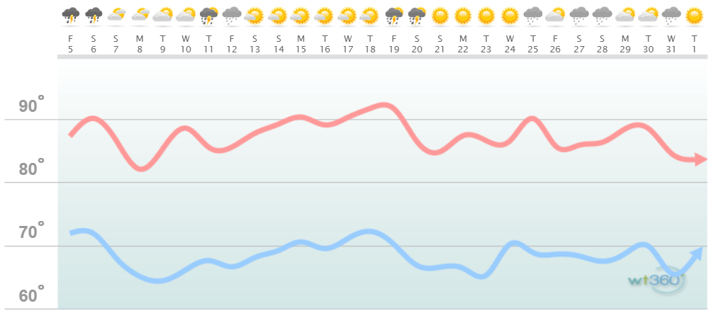
Discussion: Here we are in statistically the hottest time of year. A persistent slight negative phase of the North American Oscillation (NAO) has produced a weak block as of late. What this has done is prevent the extreme ridging from forming over the Mid-Atlantic US. Therefore the upper-jet stream is closer to NJ rather than far to our N. At the surface this means lower temperatures and higher humidity. Don’t get me wrong I realize it’s hot and muggy right now. But we’re dealing with 80s and 90s with excessive humidity not 100+ with traditional humidity. After all humidity is a temperature buffer. Its why BBQ pitmasters smoke their meats with moisture pans…for consistency of lower temperature. Sorry for the analogy but in summary the excessive humidity has prevented the excessive heat and instead only allowed for regular summer heat. I expect to see more of the same through July.
Also sea surface temperatures off the New Jersey coast are running 2-3 degrees Celsius above-average. I was surprised to see values of 72-73F up and down the coast this morning. Usually we’re just about reaching 70 this time of year. Given the blocking pattern and warmer seas its not a horrible pattern for tropical development and/or sustainment should anything form in the Atlantic Hurricane Basin. It’s still early in the hurricane season but by the end of July we’ll be getting closer to the peak.

In English: I would expect the warm, muggy and stormy pattern to continue through most of July. I don’t see any prolonged crazy hot periods where temps break 100 and heat indices break 115 kind of stuff. I see lots of 80s and 90s with higher humidity and a consistent stream of scattered stormy periods moving from W to E. Again that is in general. Could we see a handful of super hot days? Sure, its July. But for the most part the status quo should remain. Have a great month of July and please be safe! JC
Jonathan Carr (JC) is the founder and sole operator of Weather NJ, New Jersey’s largest independent weather reporting agency. Since 2010, Jonathan has provided weather safety discussion and forecasting services for New Jersey and surrounding areas through the web and social media. Originally branded as Severe NJ Weather (before 2014), Weather NJ is proud to bring you accurate and responsible forecast discussion ahead of high-stakes weather scenarios that impact this great garden state of ours. All Weather. All New Jersey.™ Be safe! JC


LOCAL FORECAST | INTERACTIVE RADAR | LATEST NJ WEATHER ALERTS | WEDDING FORECAST| PRIVACY POLICY
© Copyright 2026 Weather NJ LLC. All Rights Reserved.
Some information that can be found on our website is provided by a private weather station and is not an officially recognized station for weather reporting. Though we always strive to achieve accurate reporting for our own use, it is important that you do NOT depend on the data provided here for any purpose.
