

July 31: Isaias Impact on East Coast
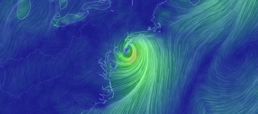
Discussion: Earlier this week we started talking about a potential tropical threat for the east coast around August 5 from what was Invest 92L. Today this system is a category 1 hurricane named Isaias heading into the Bahamas.
From its current location, it should track fairly close to the E Florida coast, possibly making landfall, and then head towards the E NC/OBX region. Before anyone panics, yes this system is likely heading for NJ but AFTER interacting with E NC land. Therefore, I do not see this being any stronger than a tropical storm/weak cat 1 hurricane after emerging back over water near Delmarva. My best guess right now for NJ impacts is a remnant tropical storm that’s starting to transition to an extra-tropical cyclone by NJ latitude.
A central US trough will be a major player in the steering influence of Isaias. Since Isaias will not likely phase with the upper-level low associated with the trough, it will instead feel the influence of upper-level SW flow. This should help steer the storm back to the NE after peaking in westward extent somewhere near NE FL/GA. The other major steering influence is the Bermuda high (a ridge of anti-cyclonic flow near or just E of Bermuda). The trough and ridge should combine to transition Isaias from the tradewinds up into the mid-latitude westerlies. So we basically have a storm track similar to the shape of the east coast.
E Florida has the best chance to see the strongest tropical characteristics of Isaias. After that the E Carolinas will probably see a weakening system make landfall somewhere between Myrtle Beach, SC and the tip of OBX. By the time the remnants get to Delmarva latitude there will be interaction with the trough and possibly extra-tropical transition.
So what does this mean for NJ? I think at the very least we’re looking at periods of drenching rainfall. The moisture from the tropical system itself will be interacting with the lifting of the trough. As far as winds go, not seeing anything terribly destructive. Maybe the winds you are used to during a coastal storm or nor’easter. Coastal flooding would have the best chance to happen just N of the system where the easterly fetch is strongest. Once the system passes, winds would switch to more of a westerly flow. There should only be one high tide of concern, two at the most, and these levels should stay in the minor category.
Once Isaias remnants clear NJ and head away to the NE, conditions should improve rather quickly behind. The current weekend outlook talks a little more about next week.
In English: Careful not to freak out should you hear about tropical storm warnings or any other tropics warnings. NJ will likely not deal with a major landfalling storm. We have a tropical system that will likely parallel the east coast from FL through OBX, weakening as it does. It should impact NJ in the Monday-Tuesday period of this coming week with drenching rain, moderate winds and minor coastal flooding. These are run-of-mill conditions similar to coastal storms and nor’easters that NJ commonly weathers. But because it is a tropical named system, the warnings would technically have to fly by the NWS. Bottom line, I think we’re looking at more of a nuisance rather than a destructive scenario this coming Monday into Tuesday. Please enjoy your weekend and be safe! JC
Download the new free Weather NJ mobile app on Apple and/or Android. It’s the easiest way to never miss Weather NJ content. Our premium services go even further above and beyond at the hyper-local level. Looking for industrial-caliber long-range forecasting data that I personally recommend? Check out WeatherTrends360!
Jonathan Carr (JC) is the founder and sole operator of Weather NJ, New Jersey’s largest independent weather reporting agency. Since 2010, Jonathan has provided weather safety discussion and forecasting services for New Jersey and surrounding areas through the web and social media. Originally branded as Severe NJ Weather (before 2014), Weather NJ is proud to bring you accurate and responsible forecast discussion ahead of high-stakes weather scenarios that impact this great garden state of ours. All Weather. All New Jersey.™ Be safe! JC


LOCAL FORECAST | INTERACTIVE RADAR | LATEST NJ WEATHER ALERTS | WEDDING FORECAST| PRIVACY POLICY
© Copyright 2026 Weather NJ LLC. All Rights Reserved.
Some information that can be found on our website is provided by a private weather station and is not an officially recognized station for weather reporting. Though we always strive to achieve accurate reporting for our own use, it is important that you do NOT depend on the data provided here for any purpose.
