

July 8: Coastal Disturbance Detected
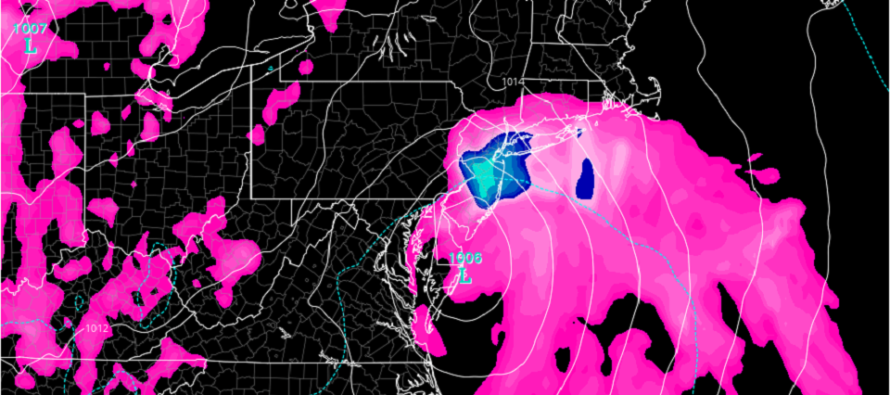
Discussion: A low pressure disturbance is currently forming on the coastal border of North and South Carolina. We’re not talking about a powerful system but organized enough to bring nuisance-to-mildly-disruptive conditions to the E US coast (OBX to NYC) between tonight and Friday.
Model guidance never really drops the surface low below 1004mb even when the storm reaches maximum strength Thursday night into Friday morning/afternoon. So again, this is not as much of a dangerous hazard as it is a plan disrupter for the beaches.
This system, whether the National Hurricane Center (NHC) names it Fay or not (for sub-tropical justification) will likely bring moderate to possibly heavy rainfall (at times) to most of New Jersey between late-Thursday PM and Friday afternoon with Friday morning likely the main slug of precipitation.
Winds will likely not be destructive especially away from the immediate coast. My gut feel is about 15-25mph sustained with gusts to 40mph for the immediate coast with lesser values away from the ocean. My only real concern about wind is the potential coastal flooding that could result from the prolonged onshore flow (out of the E/SE). My best gut feel on that are minor levels of coastal flooding all below Highest Astronomical Tide (HAT) levels. Water in the streets that normally see water in the streets and only for 1-2 high tides, not 4-6 high tides like a traditional stalled or retrograded nor’easter.
In English: Initial winds should pick up off the ocean late Thursday evening for New Jersey, primarily for immediate ocean-facing coastal areas of ECNJ and SENJ. Moderate rainfall is possible from late Thursday night through early Friday afternoon. Minor coastal flooding is possible for SENJ/ECNJ during this window. The system is a fast mover and should be out of here by Friday afternoon. The bottom line is that we’re looking at a nuisance coastal event not a destructive one. That’s my gut feel for now and I will update accordingly. Have a great day and please be safe! JC
Download the new free Weather NJ mobile app on Apple and/or Android. It’s the easiest way to never miss Weather NJ content. Our premium services go even further above and beyond at the hyper-local level. Looking for industrial-caliber long-range forecasting data that I personally recommend? Check out WeatherTrends360! Visit the Weather NJ Kaboom Shop for hoodies, tees and infant onesies.
Jonathan Carr (JC) is the founder and sole operator of Weather NJ, New Jersey’s largest independent weather reporting agency. Since 2010, Jonathan has provided weather safety discussion and forecasting services for New Jersey and surrounding areas through the web and social media. Originally branded as Severe NJ Weather (before 2014), Weather NJ is proud to bring you accurate and responsible forecast discussion ahead of high-stakes weather scenarios that impact this great garden state of ours. All Weather. All New Jersey.™ Be safe! JC


LOCAL FORECAST | INTERACTIVE RADAR | LATEST NJ WEATHER ALERTS | WEDDING FORECAST| PRIVACY POLICY
© Copyright 2026 Weather NJ LLC. All Rights Reserved.
Some information that can be found on our website is provided by a private weather station and is not an officially recognized station for weather reporting. Though we always strive to achieve accurate reporting for our own use, it is important that you do NOT depend on the data provided here for any purpose.
