

July 8: Severe Weather Possible Tomorrow!
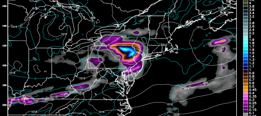
A low pressure disturbance will track from the southern Great Lakes directly over New York City tomorrow. This synoptic system will plunge into an air mass favorable for thunderstorms (some humidity and marginal instability). This will also create a conflict in wind direction between the surface and aloft when the system moves through. Because of this, thunderstorms are possible containing heavy downpours, flash flooding and damaging winds. As far as timing goes, this system should likely approach WNJ by late-afternoon and clear ENJ by midnight.
The National Weather Service Storm Prediction Center (NWS SPC) has issued the following convective outlook:
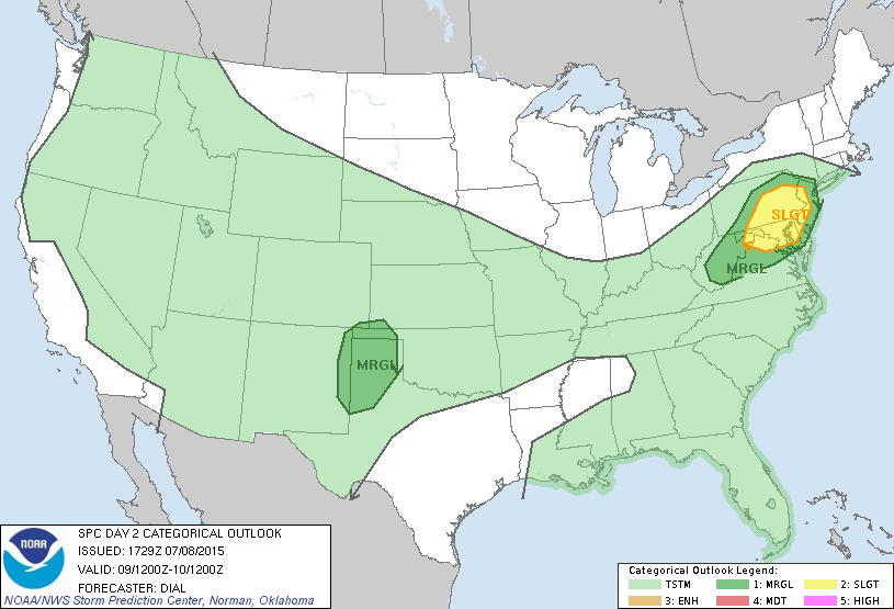
As you can see, the greatest area of risk includes western parts of New Jersey, most of EPA, DC, Baltimore, and Philadelphia. The rest of New Jersey and New York City are at a lower level of risk of severe weather but not at zero risk. Given the conflict in wind direction between S/SW flow ahead of the system and W flow on the southern end of the actual system, I wouldn’t be surprised to see rotation detected aloft and possibly even a tornado in that high-risk EPA/WNJ region. Otherwise, most wind damage should likely occur from straight-line winds in excess of 60mph. Hail is very possible with this system as well.
In English: Expect thunderstorms tomorrow afternoon through evening. Some may reach severe criteria for winds in excess of 58mph and/or hail of one inch in diameter or greater. Frequent lightning, heavy downpours capable of producing flash flooding, and even hail are possible. WNJ areas (Gloucester, Camden, Burlington, Mercer, Hunterdon and Warren Counties) have the best chance to see severe thunderstorms. All other NJ counties are subject to anything from weakening (but still strong) thunderstorms to fizzling showers. I’ll see you tomorrow during nowcasting. Be safe! JC
Jonathan Carr (JC) is the founder and sole operator of Weather NJ, New Jersey’s largest independent weather reporting agency. Since 2010, Jonathan has provided weather safety discussion and forecasting services for New Jersey and surrounding areas through the web and social media. Originally branded as Severe NJ Weather (before 2014), Weather NJ is proud to bring you accurate and responsible forecast discussion ahead of high-stakes weather scenarios that impact this great garden state of ours. All Weather. All New Jersey.™ Be safe! JC


LOCAL FORECAST | INTERACTIVE RADAR | LATEST NJ WEATHER ALERTS | WEDDING FORECAST| PRIVACY POLICY
© Copyright 2026 Weather NJ LLC. All Rights Reserved.
Some information that can be found on our website is provided by a private weather station and is not an officially recognized station for weather reporting. Though we always strive to achieve accurate reporting for our own use, it is important that you do NOT depend on the data provided here for any purpose.
