

July 9: Coastal Storm Approaching
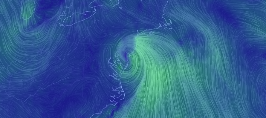
Discussion: Our coastal system is organizing just SE of Bald Head Island, NC (S OBX). The latest trends in model guidance indicate the system riding slightly further W up the back of the ridge which will be located over NE US/SE Canada at the time of peak impact. This would mean a surface low track possibly over NJ instead of right along, or just off, the Jersey coast.
Timing is still holding with the main slug of precipitation occurring for NJ between late tonight and tomorrow afternoon. The rain will be moving with the system from S to N. It should approach Cape May around midnight tonight, peak tomorrow morning (Friday) and then clear from S to N during tomorrow afternoon. Since NNJ will be last to see the rain start and end, the rain might clear closer to early evening rather than afternoon like S parts of the state. But either way this system looks to bring most, of not all, of NJ at least periods of moderate rainfall. The jackpot zone of rain totals should be the width of NJ. However, whether that vertical swath of highest rain totals occurs over WNJ or ENJ is still yet TBD and will be mostly based on the low’s actual track. The further W the track, the further W the primary precipitations swath. The ultra short-range guidance today and this evening should real this range of possibility in some.
Some shorter-range model guidance indicates a slightly stronger storm (closer to 1000mb possibly upper-990s). This would mean that peak onshore coastal wind gusts could exceed 50mph rather than 40mph. Either way this is the kind of system where coastal regions, especially the ocean-facing beach areas of ECNJ/SENJ, see much higher wind values than areas inland. This is due to land friction and the reason why areas further inland might be asking, “What winds?” But whether or not the low reaches an intensity of between 998mb or 1005mb will like mean the difference between max coastal gusts of 50mph+ or 40mph. That seems to be the current range. Again, lesser wind values inland but still noticeable.
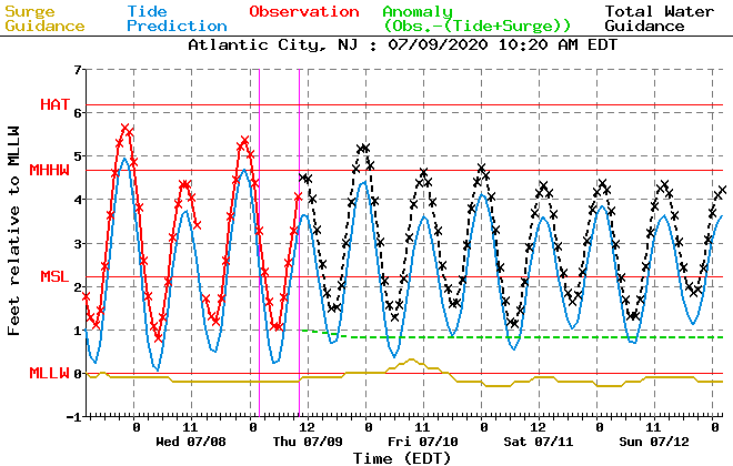
Coastal flooding potential is still modeled as minor with only a small chance of approaching moderate levels. With a weaker storm (relative to other storms we’ve seen) and its quick moving nature, coastal flooding is more probable to stay in the minor category. But I will say, the onshore flow could be more out of the E/SE rather than E especially if the system takes a track slightly W into NJ rather than along the coast. E/SE is worst for coastal flooding since it aligns with most SENJ inlets. Just something to watch in case some of the said areas see more of a moderate coastal flooding event rather than minor. Here’s the latest tidal guidance for Atlantic City, NJ from NOAA MDL:
In English: Moderate-to-heavy rainfall is approaching NJ. It should begin around midnight tonight in Cape May (as onshore winds begin to pick up) and end in NNJ by late tomorrow afternoon/early tomorrow evening. SNJ should be finished first (as early as noon tomorrow). The rain will start and stop from S to N. Winds should be noticeable away from the ocean but gusty along the coast (40-50mph+ on the table for immediate coast). Minor-to-moderate levels of coastal flooding are possible for ECNJ/SENJ. So the coastal storm starts late tonight, peaks tomorrow morning and wraps up tomorrow afternoon. Have a great rest of your Thursday and please be safe! JC
Download the new free Weather NJ mobile app on Apple and/or Android. It’s the easiest way to never miss Weather NJ content. Our premium services go even further above and beyond at the hyper-local level. Looking for industrial-caliber long-range forecasting data that I personally recommend? Check out WeatherTrends360! Visit the Weather NJ Kaboom Shop for hoodies, tees and infant onesies.
Jonathan Carr (JC) is the founder and sole operator of Weather NJ, New Jersey’s largest independent weather reporting agency. Since 2010, Jonathan has provided weather safety discussion and forecasting services for New Jersey and surrounding areas through the web and social media. Originally branded as Severe NJ Weather (before 2014), Weather NJ is proud to bring you accurate and responsible forecast discussion ahead of high-stakes weather scenarios that impact this great garden state of ours. All Weather. All New Jersey.™ Be safe! JC


LOCAL FORECAST | INTERACTIVE RADAR | LATEST NJ WEATHER ALERTS | WEDDING FORECAST| PRIVACY POLICY
© Copyright 2025 Weather NJ LLC. All Rights Reserved.
Some information that can be found on our website is provided by a private weather station and is not an officially recognized station for weather reporting. Though we always strive to achieve accurate reporting for our own use, it is important that you do NOT depend on the data provided here for any purpose.
