

July 9: Severe Weather Update
Storm energy is already building just south of the Great Lakes and is plotting a course for New Jersey. This update is primarily focused on timing. The possible severity of thunderstorms has not changed. EPA and WNJ are still at the highest risk for flash flooding and damaging winds from severe thunderstorms. The rest of NJ that surrounds WNJ is at a lower risk for severe weather but shouldn’t let their guard down. The National Weather Service Storm Prediction Center (NWS SPC) has elevated their risk levels since yesterday as seen here on today’s convective outlook:
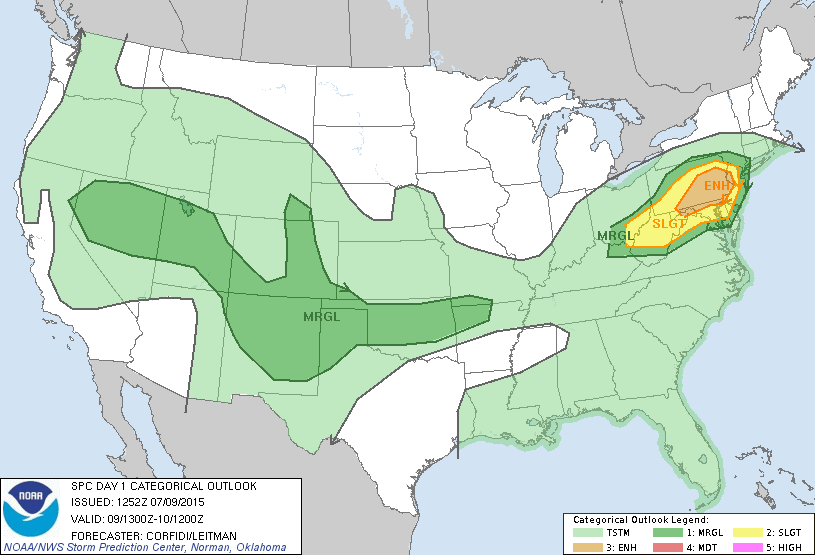
ENH stands for enhanced. SLGT stands for slight. MRGL stands for marginal. As you can see, with the exception of extreme NNJ and extreme SNJ, all of WNJ is at an enhanced or slight risk for severe weather. These are pretty aggressive categories used by the NWS so I highly advise you take them seriously.
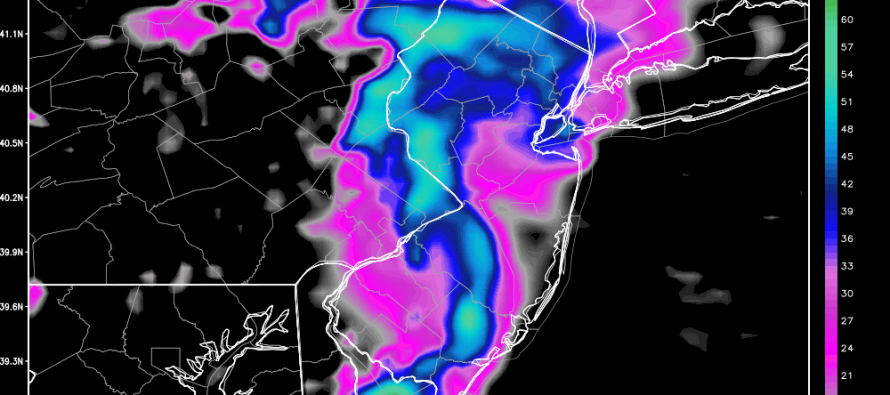
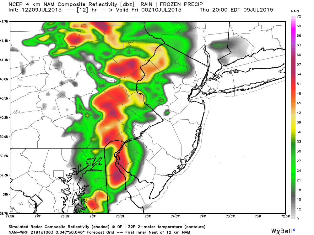
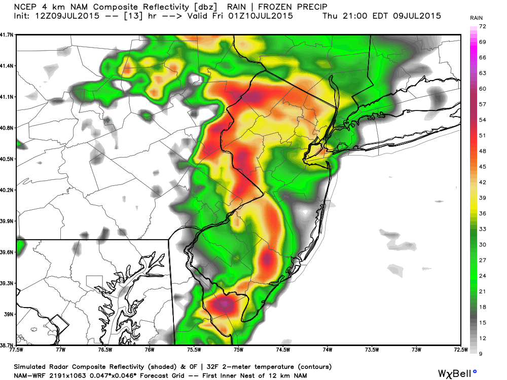
So let’s talk timing. The following model images are from the latest high-res NAM and represent 1-hour precipitation amounts ending at 8PM, 9PM, and 10PM.
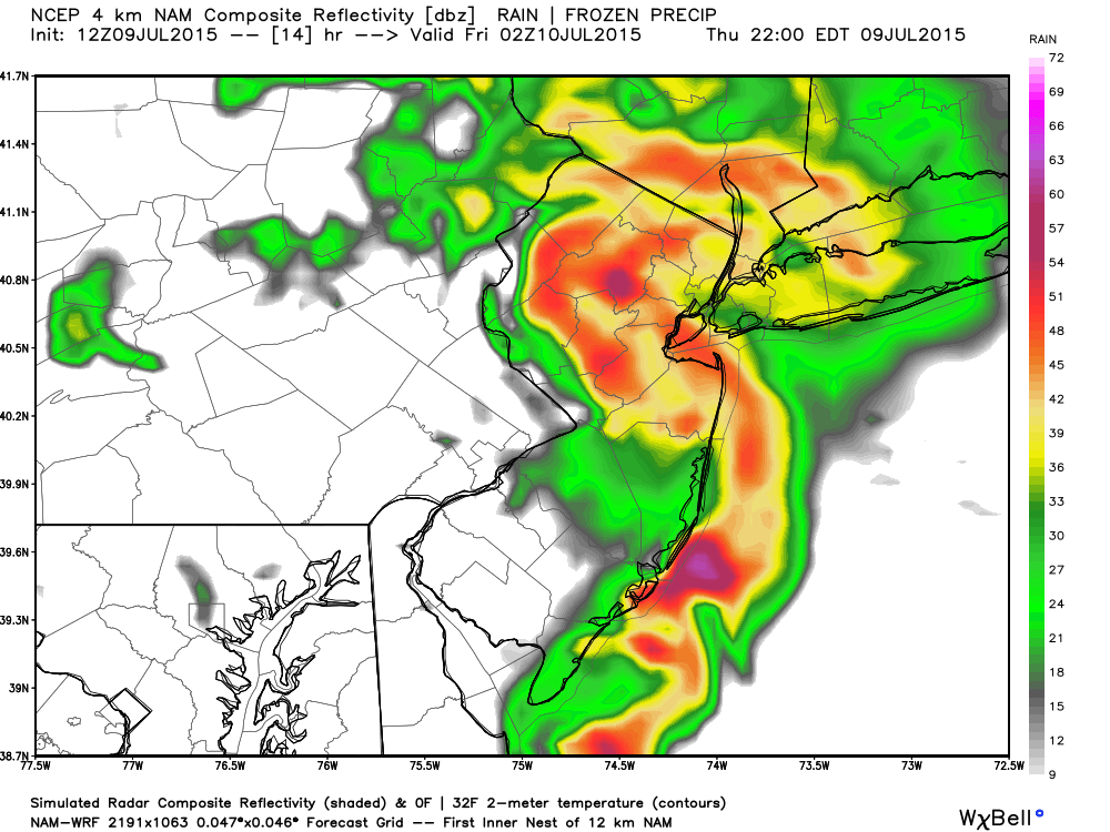
A few things jump out at me after looking at the NAM:
1) Red areas indicate periods of heavy rainfall (50+dbz). Purple areas indicate periods of torrential downpour (60+dbz). With that said along with consideration of PWAT (precipitable water) parameters ranging from 1.5 to 2.0 leads me to believe that widespread flash flooding is possible wherever the heaviest rain bands set up.
2) I see powerful outflow boundaries created from such heavy rain and down-drafting. This will create pools of cold air at the surface and allow the system to advance eastward as a large line segment. Furthermore, I see a potential bow echo pattern which indicates possible widespread damaging winds. We saw a similar instance a few weeks ago. This is not guaranteed but very possible in this setup. Notice the classic seahorse look to the simulated radar? In my experience that results in severe-warned thunderstorms for wind criteria (greater than 58mph) 9 out of 10 times.
3) I see the southern side of the storms swinging through SNJ faster than the northern side of storms in NNJ. This should be mostly due to the synoptic nature (cyclonic flow) of the approaching/passing low pressure disturbance. This further reinforces my idea of a bow echo moving through CNJ and SNJ while NNJ remains under the pivot point. At the end of the day this would separate the headlines meaing more rain in NNJ and more widespread straight line winds in SNJ despite all of New Jersey possibly seeing both. This swing movement could also generate rotation aloft. If such rotation makes it to the ground then we’ll have a tornado. Pay attention to NWS warnings in case such an occurrence happens.
In English: Expect strong to severe thunderstorms to move through the region from west to east between 6PM and midnight. The highest period of interest is currently between 7PM-10PM. These storms can contain frequent lightning, flash-flooding from heavy downpours of rain, damaging winds, hail, and possibly even a tornado. The highest area of risk is in EPA/WNJ. The rest of NJ has a lesser risk but should still be prepared. By midnight it should all clear into the ocean which should dry everything out for tomorrow and into the weekend. I’ll be tracking. Be safe! JC
Model images used with permission from WeatherBell Analytics.
Jonathan Carr (JC) is the founder and sole operator of Weather NJ, New Jersey’s largest independent weather reporting agency. Since 2010, Jonathan has provided weather safety discussion and forecasting services for New Jersey and surrounding areas through the web and social media. Originally branded as Severe NJ Weather (before 2014), Weather NJ is proud to bring you accurate and responsible forecast discussion ahead of high-stakes weather scenarios that impact this great garden state of ours. All Weather. All New Jersey.™ Be safe! JC


LOCAL FORECAST | INTERACTIVE RADAR | LATEST NJ WEATHER ALERTS | WEDDING FORECAST| PRIVACY POLICY
© Copyright 2026 Weather NJ LLC. All Rights Reserved.
Some information that can be found on our website is provided by a private weather station and is not an officially recognized station for weather reporting. Though we always strive to achieve accurate reporting for our own use, it is important that you do NOT depend on the data provided here for any purpose.
