

June 17: Possible Thunderstorms Detected
The Monday thunderstorm threat is increasing. Let’s break it down…
Discussion: A cold front is expected to push through on Monday from W to E. Right now it looks like the frontal passage will occur Monday night into Tuesday morning with frontal precipitation and thunderstorm activity likely occurring between the afternoon and evening hours of Monday. While the front will move from W to E, it should have a SW to NE axis which means NWNJ first, CNJ in the middle and SENJ last. The wind shear profile appears pretty marginal but expected diurnal-driven instability is rather impressive. In addition we have the trigger of the cold front itself plowing into a very soupy air mass. IMO, there are enough ingredients on the table to justify the possible expectation for severe thunderstorm criteria. Severe thunderstorm warnings would be issued by the NWS should wind gusts exceed 58mph and/or quarter-size or larger hail occur. These kind of setups traditionally favor interior New Jersey rather than coastal New Jersey for severe criteria chances due to marine air-mass stabilization. I’ll be monitoring and reporting on this very closely.
In English: A passing period of rain and thunderstorms are expected Monday afternoon/evening. Thunderstorms have a solid chance of severe capability. While strong (even severe) thunderstorms could still push all the way to the coast, the best severe thunderstorm chances exist in W and NW parts of New Jersey. SENJ would have the lesser chance of severe criteria (best chance for fizzle) but don’t let your guard down. We’ll have to play the radar to see how quickly any linear storm segments weaken as they approach the coast. I’ll be monitoring this closely and will have an update with the Monday-Friday Outlook posted tomorrow (Sunday). Everything should clear out to the E by Tuesday morning, including the humid air mass.
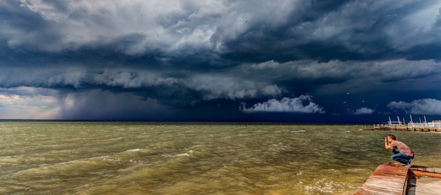
I took the above storm photo last year in Surf City, NJ (Long Beach Island). That’s Greg Molyneux in the lower-right. The thunderstorms filtered and reflected the sun’s spectrum causing the green Barnegat Bay appearance. Everyone have a great Saturday and be safe! JC
Jonathan Carr (JC) is the founder and sole operator of Weather NJ, New Jersey’s largest independent weather reporting agency. Since 2010, Jonathan has provided weather safety discussion and forecasting services for New Jersey and surrounding areas through the web and social media. Originally branded as Severe NJ Weather (before 2014), Weather NJ is proud to bring you accurate and responsible forecast discussion ahead of high-stakes weather scenarios that impact this great garden state of ours. All Weather. All New Jersey.™ Be safe! JC


LOCAL FORECAST | INTERACTIVE RADAR | LATEST NJ WEATHER ALERTS | WEDDING FORECAST| PRIVACY POLICY
© Copyright 2026 Weather NJ LLC. All Rights Reserved.
Some information that can be found on our website is provided by a private weather station and is not an officially recognized station for weather reporting. Though we always strive to achieve accurate reporting for our own use, it is important that you do NOT depend on the data provided here for any purpose.
