

June 3: Thunderstorms Expected Sunday

Thunderstorms are expected on Sunday, some possibly severe. It’s a complex setup with a warm front pushing through (from S to N) in the morning, a period of clearing in the afternoon followed by a cold front pushing through (from W to E) later in the evening. With that said, the timing is starting to unfold as follows:
Rain and possibly some thunderstorms are possible along the warm front Sunday morning between early AM hours and noon. During and after this rainfall, expect tropical-like conditions as dew points will be approaching/just breaking 70. At some point (my best guess right now is around 11AM-2PM), the rain will end and the sun could reach the surface. This could allow a period of humid but possibly clear conditions until the thunderstorms approach from the W/NW. The storms should span New Jersey from W/NW to E/SE between 4PM and 8PM with storm remnants lingering a few hours after, especially at the shore. That’s the best I can do right now and will make timing adjustments tomorrow if necessary.
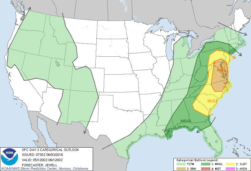
The best dynamics for severe criteria being met (wind gusts > 58mph and/or quarter-size hail or larger) are to our S/SW including eastern regions of North Carolina, Virginia, Maryland and most of the Delmarva Peninsula. This highest risk area however could include some of SE Pennsylvania and SNJ. As you head NE towards NYC and New England, the dynamics drop off mostly due to convective inhibition. The NWS Storm Prediction Center has illustrated this in their latest D3 severe outlook. You can see that while the entire state is at some level of severe risk, SWNJ is at a higher risk than NENJ:
Here’s a sounding from the latest high-resolution NAM model. The sounding represents SNJ at 18Z on Sunday when instability will be building to the highest levels of the day:
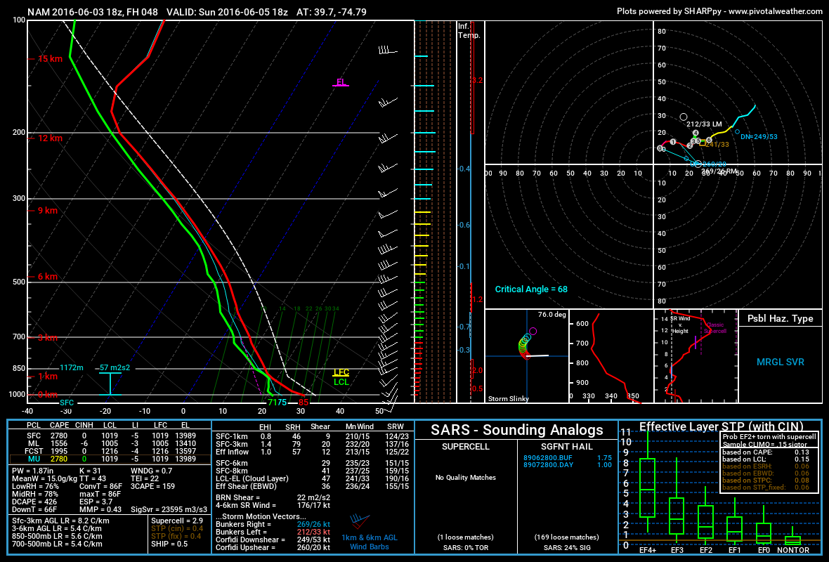
Surface-based CAPE is quite high at 2790 j/kg. Mixed-layer CAPE however is a much better core-indicator for instability (also a good indicator for lightning-frequency). 1000 j/kg of MLCAPE is generally sufficient for such. With 1556 j/kg of MLCAPE showing, this event has my interest. The Lifted Index (LI), which is the difference in C temperature from surface-500mb, is well in negative territory which is another instability parameter I like to use.
Shear seems marginally sufficient at 35-40kts (sfc-500mb bulk). There’s also a stronger 250-300mb jet along the cold front. Should any meso-low form along the front, it could assist the potentially damaging wind scenario (straight line or tornado). There’s a much better chance of that happening to our S and W but it’s worth mentioning should it form at the mesoscale level on Sunday.
So in a nutshell, we have high levels of instability, marginally sufficient wind shear and the cold front as the trigger plowing through jungle dew point temperatures. The ingredients are all there for heavy downpours of rain, light shows, wind damage and possibly some hail.
What could go wrong? If there is more cloud cover between the warm front and cold front (during the afternoon), then instability could be inhibited. This would mean a much weaker overall event. It would likely be in the form of widespread rainfall with strong embedded thunderstorms rather than a fierce line of severe storms approaching through sunny skies. Sun’s out guns out! We’ll know this the day of but most model guidance is at least giving way to a few hours of sun reaching the surface before the cold front.

In English: Expect rain and possibly some isolated embedded thunderstorms early Sunday morning through about noon. A period of clearing (likely very humid) is then possible between noon and late-afternoon/early evening. Thunderstorms, possibly severe, should then roll through from W/NW to E/SE between 4PM and 8PM with lingering rainfall possible through about 11PM. That’s the best I can do right now. Be safe! JC
Image Credit: Chris Spiegel of Blur Revision Media Design
Jonathan Carr (JC) is the founder and sole operator of Weather NJ, New Jersey’s largest independent weather reporting agency. Since 2010, Jonathan has provided weather safety discussion and forecasting services for New Jersey and surrounding areas through the web and social media. Originally branded as Severe NJ Weather (before 2014), Weather NJ is proud to bring you accurate and responsible forecast discussion ahead of high-stakes weather scenarios that impact this great garden state of ours. All Weather. All New Jersey.™ Be safe! JC


LOCAL FORECAST | INTERACTIVE RADAR | LATEST NJ WEATHER ALERTS | WEDDING FORECAST| PRIVACY POLICY
© Copyright 2025 Weather NJ LLC. All Rights Reserved.
Some information that can be found on our website is provided by a private weather station and is not an officially recognized station for weather reporting. Though we always strive to achieve accurate reporting for our own use, it is important that you do NOT depend on the data provided here for any purpose.
