

Late-Weekend Snowstorm a GO!
Discussion: Today is the last day of general tracking and model analysis prior to tomorrow’s initial snow map containing expected snow accumulations and other various storm impacts. There is no map yet today. However, we are forming a general idea of what should happen.
All previously mentioned upper level ideas are in place and are much more consistently modeled. This includes tomorrow’s (Thursday) missed phase going onto form a 50/50 low for Saturday-Sunday…holding down a ridge in the NE US…and ultimately shaping the track of the coastal low. The low has just come off the Pacific ocean into the SW US and will track across the US from W to E between now and Sunday. The low will dip southward in its track into TX, scoop up some gulf moisture and then head towards the Atlantic Ocean somewhere over N OBX/S Delmarva.
This track is inside (to the W of) the classic/ideal track needed for a NJ-statewide snowstorm. Therefore, we’re looking at a traditional I-95 corridor dividing the plowable snow to the NW from rain and wind to the SE. Regardless of precipitation type, first flakes/drops should begin between 4-7pm Saturday. Conditions should intensify overnight into Sunday morning and taper off by noonish Sunday. I would expect region-wide wind gusts in the 20-30mph range with immediate ECNJ/SENJ coastal areas subject to wind gusts of 35-50mph. The high tide to occur near midnight Saturday night/just after should put the most amount of water in the streets in coastal places that normally see water in the streets. Def at least a minor coastal flooding concern.
As far as snow vs rain, here are my current thoughts:
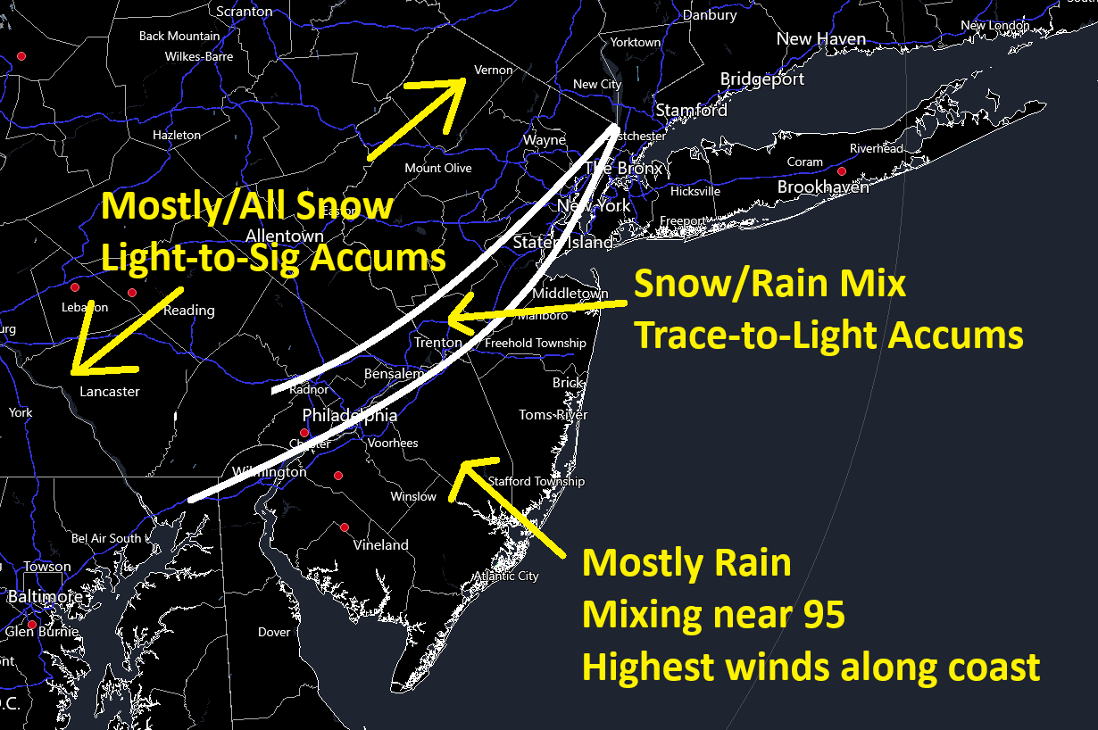
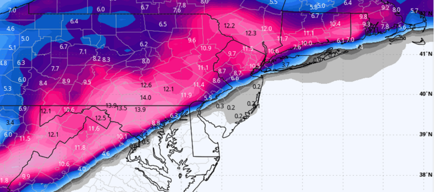
My best guess from this range is a 4-8, maybe 5-9 inch snowstorm for the Mostly/All Snow area. The Snow/Rain Mix area is the most uncertain…basically 0-4 inches of snow dependent on what wins out (cold damming vs warmer marine flow). The Mostly Rain area is straightforward although snow mixing is possible closest to 95, def not towards the close.
We’re in for a few cold nights leading into this system. This should create a cold air damming situation along the piedmont of the Appalachian Mountains. The ocean however is still 45F degrees and the east flow off the ocean (associated with the low) should push above-freezing air all the way to the general I-95 corridor for most of the event. I suppose it’s possible more areas end with some finishing snow but I am highly skeptical of snow accumulations SE of I-95/NJTP. It’s possible but precipitation rates would have to cool the column via dynamic cooling to override the warmer flow. 9 times out of 10 the marine flow wins out warm all the way to I-95. The real winner of this storm still seems like NWNJ and possibly down to I-78 which would include most of NNJ and some of WCNJ. Our snow map will detail this better tomorrow.
In English: A winter storm is developing for NWNJ (NW of the turnpike) this Saturday PM-Sunday AM. Plowable snow is becoming likely for this area. Still seems like mostly rain along and SE of the turnpike but the turnpike/I-95 corridor itself could see trace-to-light snow accums mixed in with rain. We’ll see. The worst winds will be along the ECNJ/SENJ coast which constitutes a coastal flooding threat. The storm should begin between 4-7pm on Saturday, peak between Saturday night and 9am Sunday, and taper off by noon Sunday for most areas. Tomorrow will be an actual forecast snow and impact map. Have a great rest of your Wednesday evening and please be safe! JC
Premium Services
KABOOM Club offers inside info forecast discussion, your questions answered, and early storm impact maps (ahead of the public). At a buck per month, it’s an extremely feasible way to show support.
My Pocket Meteorologist (MPM), in partnership with EPAWA Weather Consulting, offers professional/commercial interests, whose businesses depend on outdoor weather conditions (snow plowing, landscaping, construction, etc.), with hyper-local text message alerts/forecasts and access to the MPM premium forum—the most comprehensive and technical forecast discussion available for PA and NJ.
Get your KABOOM Inside Out pajamas and more at the KABOOM shop!
Jonathan Carr (JC) is the founder and sole operator of Weather NJ, New Jersey’s largest independent weather reporting agency. Since 2010, Jonathan has provided weather safety discussion and forecasting services for New Jersey and surrounding areas through the web and social media. Originally branded as Severe NJ Weather (before 2014), Weather NJ is proud to bring you accurate and responsible forecast discussion ahead of high-stakes weather scenarios that impact this great garden state of ours. All Weather. All New Jersey.™ Be safe! JC


LOCAL FORECAST | INTERACTIVE RADAR | LATEST NJ WEATHER ALERTS | WEDDING FORECAST| PRIVACY POLICY
© Copyright 2026 Weather NJ LLC. All Rights Reserved.
Some information that can be found on our website is provided by a private weather station and is not an officially recognized station for weather reporting. Though we always strive to achieve accurate reporting for our own use, it is important that you do NOT depend on the data provided here for any purpose.
