

Less Hot but Still Unsettled – Watching Lee
Discussion: The high-pressure area NE of Bermuda, that is currently steering Major Hurricane Lee to the W/NW underneath it, will provide S winds for NJ this weekend. This will be around the W side of anti-cyclonic flow. High temperatures will take a step down for Saturday-forward (from the 90s to the 80s for many) however the S flow will keep the humidity around well into next week. I expect Saturday and Sunday to be similar to today regarding showers and storms…isolated activity only. Not a washout. A very tropical look and feel including soft towering cumulus clouds, mostly sunny skies, but the chance for a shower or t-storm to pop anytime anywhere and not so much on a large scale. Again, some disruptions possible but not a washout. Monday and Tuesday look similar but with even less of a chance for iso pop-ups.
On Wednesday a cold front arrives, and we have to be thankful for this one: 1) It is on the front of a trough that will likely keep Lee out to sea via steering currents rounding the base of the trough. 2) It means cooler and drier air, more typical of average September conditions…not the hot mess we’re in now. So you really want to see a round of frontal showers push through and out to sea Wednesday PM into Thursday AM. This will mean the meteorological principals and steering currents will be in place to keep Lee offshore of NJ. Thursday through the rest of the weekend then looks incredible with lower temperatures and lower humidity. Very comfortable, especially Friday night through Sunday morning including all of Saturday. We’re talking high temps in the 70s with dews in the 40s. But let’s get through mid-next week first.
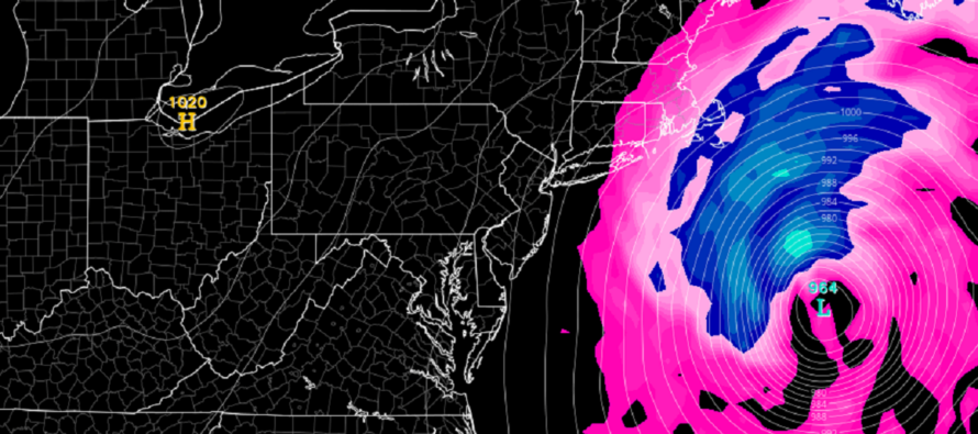
Lee is an absolute monster of a major hurricane. From a Tropical Depression Tuesday to a category 5 Thursday night is just bonkers. We’re probably going to see some eyewall replacement cycles and trochoidal oscillations that weaken Lee at times. It will likely stay at least a strong 3 or 4 for the next few days. It is still tracking very slowly to the W/NW. If you read my article yesterday, we are still in part 1 of how I think this logically plays out.
Today it is looking more likely that NJ will be spared from primary impacts (destructive winds and dangerous storm surge) of Major Hurricane Lee. Secondary impacts however (dangerous rip currents, elevated surf, minor-to-moderate coastal flooding, etc.) are still expected in the Wed-Fri window for mainly ENJ coasts. We should not confuse the frontal rain possible for NJ Wed-Thurs with rain from Lee. The precipitation shields will be separated by a dry area between despite the upper levels interacting with each other to possibly enhance the front. It would take major changes at this point to suggest a NJ or Mid-Atlantic US landfall. I can’t bet the farm just yet but that’s how I’m leaning. The upper low of the trough could phase with Lee (just like Sandy) but much further N along the US east coast in the Friday-Saturday period. This would mean an extreme E Maine/Nova Scotia direct hit by likely an extra-tropical cyclone. But it would spare Jersey. I will continue to update accordingly.
Friday (Sept 8) high temperatures, as of Friday Sept 8 at 345pm, are maxing in the mid-to-upper 80s for many in NNJ and SENJ. Some areas away from the ocean and closer to the turnpike have broken into the 90s, especially the Cherry Hill/Philly area up through Trenton. Much of Monmouth County is cooler from the t-storm dumping that just occurred. Thunderstorms, some severe-warned, are training from central Burlington through Ocean and Monmouth and into Bergen a bit. This activity if possible statewide through the rest of the afternoon but should quiet down as we lose sunlight. Friday should be the last of the hot days making up the anomalously warm start to September. Winds should remain light out of the S/SW (obviously higher near or under a t-storm) overnight as temps feather down to the 65-75 range from NNJ elevations to SNJ coasts. Isolated showers and storms remain possible into Saturday morning.
Saturday (Sept 9) high temperatures should reach the low-to-mid 80s for most NJ locations. Skies should be mixed with sun and clouds with a humid feel. Isolated showers and thunderstorms are possible but far from a washout. More like a typical Florida day with a tropical feel and random pop-ups. 80s will still feel very warm with the humidity. Winds should be light out of the SE. Overnight lows should range from 65-75 from NNJ elevations to SNJ coasts.
Sunday (Sept 10) high temperatures should range from upper-70s to lower-80s from NNJ elevations to SNJ coasts. Skies should be mixed with sun and clouds with a humid feel. Showers and thunderstorms are possible and given the tropical environment, downpours could be heavy. Winds should remain light out of the SE. Overnight lows should range from 65-70 from NNJ elevations to SNJ coasts.
An early look at next week is a little hard to fit into a few lines. Temp-wise, we’re looking at upper-70s to lower-80s for highs. Given the Lee situation, a lot is yet TBD (see discussion above). It’s safe to assume the humidity will remain in place until Lee pulls away and takes it with it. It is also safe to assume that NJ could deal with frontal rain/storms around the same time Lee will be passing by (Thurs-Friday). In theory, this would set up an immaculate next weekend of NW flow and very low humidity. I plan to post the weekly outlook by Sunday evening which will include much greater detail about any impacts NJ could see from Lee Thursday-Friday. For now, still leaning towards a NJ miss that could rough up the coasts/surf/etc. and possibly more of a direct Nova Scotia/E Maine strike. My suggestion is to let it all play out this weekend without worrying about it yet. If the status quo exists Sunday night then you might want to consider changing any ocean plans for later in the week.
Premium Services
KABOOM Club offers inside info forecast discussion, your questions answered, and early storm impact maps (ahead of the public). At a buck per month, it’s an extremely feasible way to show support.
My Pocket Meteorologist (MPM), in partnership with EPAWA Weather Consulting, offers professional/commercial interests, whose businesses depend on outdoor weather conditions (snow plowing, landscaping, construction, etc.), with hyper-local text message alerts/forecasts and access to the MPM premium forum—the most comprehensive and technical forecast discussion available for PA and NJ.
Jonathan Carr (JC) is the founder and sole operator of Weather NJ, New Jersey’s largest independent weather reporting agency. Since 2010, Jonathan has provided weather safety discussion and forecasting services for New Jersey and surrounding areas through the web and social media. Originally branded as Severe NJ Weather (before 2014), Weather NJ is proud to bring you accurate and responsible forecast discussion ahead of high-stakes weather scenarios that impact this great garden state of ours. All Weather. All New Jersey.™ Be safe! JC


LOCAL FORECAST | INTERACTIVE RADAR | LATEST NJ WEATHER ALERTS | WEDDING FORECAST| PRIVACY POLICY
© Copyright 2026 Weather NJ LLC. All Rights Reserved.
Some information that can be found on our website is provided by a private weather station and is not an officially recognized station for weather reporting. Though we always strive to achieve accurate reporting for our own use, it is important that you do NOT depend on the data provided here for any purpose.
