

Light, Maybe Plowable, Snow for NJ on Tuesday
Discussion: We’ve seen a two-part step-down in temperatures over the last few days. The first being a cold front attached to the Friday night system. This introduced the first gear of cold behind it which I consider stale Canadian cold air. It was cold enough to put NJ just below freezing last night but many made it well into the 40s today. A second cold front is now pushing through and this will introduce the second gear of cold. You’ll see when the temps plummet behind the Arctic front. This should happen for most today by evening hours. The Arctic front is currently, at 145pm Sunday, located near State College, PA. We’ll then enter an Arctic air mass that should stick around until around January 22.
Within the period of cold that starts today and ends around January 22, are a few snow opportunities. There were the snow squalls today and then accumulating snow is likely Tuesday. Then a potentially larger snow event for Friday into Saturday (Jan 19-20). The squalls are through so let’s discuss the approaching Tuesday system.
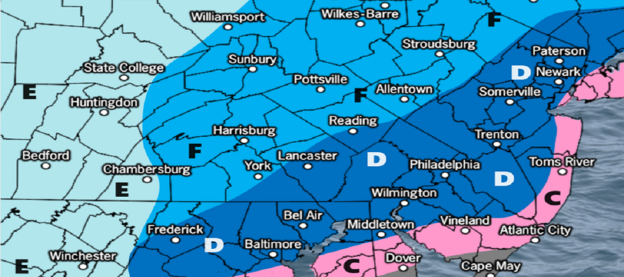
A low came off the Pacific Ocean and is tracking across the US from W to E, meeting up with some energy off the Gulf of Mexico tomorrow (Monday). This interaction has never been modeled as a strong phase ahead of a deep trough. Instead, it is only loosely interacting, just enough to redevelop into a weaker low off the Mid-Atlantic US that will butt up against an Arctic wall of cold on Tuesday. Therefore, it is more of a zonal wave than a meridional wrap-up. The axis of snow should span from WV through NY/PA/NJ. Any precipitation that falls NW of the Arctic wall will not only be snowfall, but higher-ratio snowfall. It will all stick immediately and will easily continue to accumulate. What’s uncertain is where the Arctic wall will hold up (closer to I-95 or maybe right along the coast). Areas SE of this Arctic wall could encounter mixing issues or even rain if the weak low passes too close to NJ. The GFS and Euro have a colder solution with the Arctic Wall closer to the coast—allowing all of NJ to get in on the light-to-plowable jackpot outcome of this system. The shorter-rage models, however, are coming in with a greater warm air advection off the ocean. This would mean areas of I-95 start out with maybe an inch or two of snow before going over to either sleet or rain. I will say that I am highly suspect of rain anywhere with how cold it will be. I can, however, understand some warmer lower-mid levels working in and at least changing precip type from snow to sleet/freezing rain SE of I-95. Areas along I-95 and NW would be on the other side of the Arctic wall and therefore be much colder for an all snow solution. This would be the best place to see greater than 4 inches of snow.
So before showing this map, let me repeat that I am highly suspect of zone C. I think it will behave more like zone B with only extreme SENJ seeing the mixing issues. But we have to allow the possibility of accumulations being knocked down by either sleet or rain. Zone C would have the best chance of that. Tomorrow we might eliminate at least some of zone C if we see that the warmer models were over-reacting to land sampling. Or we might keep it if we think the meso guidance is correct and matches upstream observations. Either way, this is our first call and we’ll tweak it tomorrow as needed:
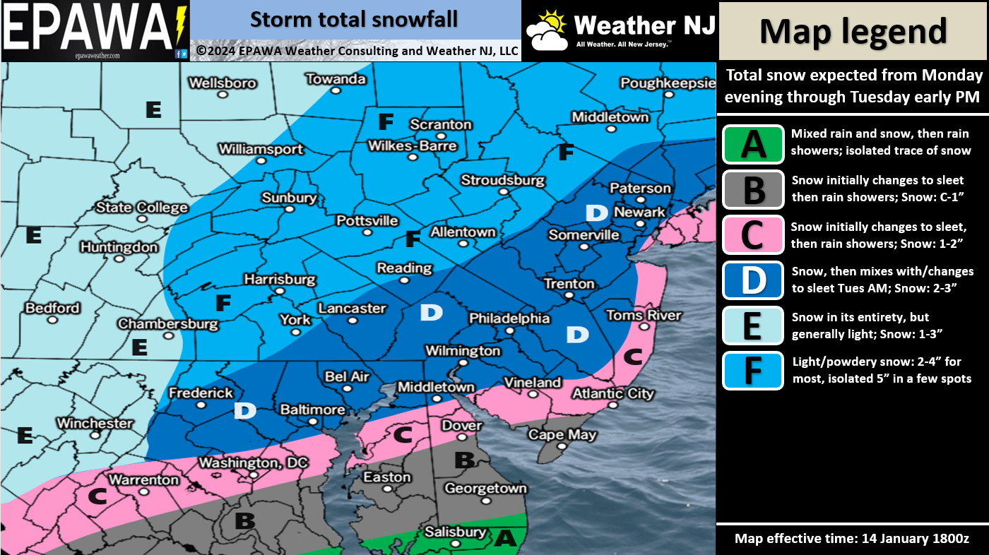
Timing: The first part of the system should move in as early as Monday night (first for WNJ) but no later than early Tuesday morning. It will then spread further into the rest of NJ. This is when everyone will be cold enough to see accumulating snow including SNJ. This is when ECNJ and SENJ have their best chance of snow accumulations if any. By sunrise Tuesday, most of NJ should be snowing. Between Tuesday morning and afternoon is when any snow/sleet or sleet/rain lines could push into SENJ towards I-95. Areas along I-95 and NW would stay snow. Snow/sleet and sleet/rain lines would then work their way back to the SE heading into Tuesday afternoon as precipitation wraps up by late Tuesday evening (last for ENJ).
The Friday-Saturday (Jan 19-20) system is gaining support for a larger snow outcome than Tuesday. Today’s guidance mostly suggests an inverted trough for the event so I expect lots of changes on data especially as the Tuesday system pushes through. Our first forecast and snow map for Friday-Saturday would likely occur Wednesday, once the Tuesday system moves out. Casual monitoring, watching, and discussion about it until then.
In English: It will get much colder tonight and stay cold through Monday into Tuesday. Snow is then expected to fall for most of Tuesday (could start Monday night). Most of NJ is on the hook for a widespread 1-3 inches, pockets of 2-4, and isolated 4+ amounts. NWNJ would have the best chance for accumulations. SENJ would have the least chance as some mixing could occur from marine influence. My gut feeling says mixing is def possible along immediate coastal areas but will struggle to warm the Arctic wall of air that should set up somewhere just away from the immediate coast. We will update our snow map and forecast tomorrow as needed. Have a great rest of your Sunday. Stay warm and be safe! JC
Premium Services
KABOOM Club offers inside info forecast discussion, your questions answered, and early storm impact maps (ahead of the public). At a buck per month, it’s an extremely feasible way to show support.
My Pocket Meteorologist (MPM), in partnership with EPAWA Weather Consulting, offers professional/commercial interests, whose businesses depend on outdoor weather conditions (snow plowing, landscaping, construction, etc.), with hyper-local text message alerts/forecasts and access to the MPM premium forum—the most comprehensive and technical forecast discussion available for PA and NJ.
Get your KABOOM Inside Out pajamas and more at the KABOOM shop!
Jonathan Carr (JC) is the founder and sole operator of Weather NJ, New Jersey’s largest independent weather reporting agency. Since 2010, Jonathan has provided weather safety discussion and forecasting services for New Jersey and surrounding areas through the web and social media. Originally branded as Severe NJ Weather (before 2014), Weather NJ is proud to bring you accurate and responsible forecast discussion ahead of high-stakes weather scenarios that impact this great garden state of ours. All Weather. All New Jersey.™ Be safe! JC


LOCAL FORECAST | INTERACTIVE RADAR | LATEST NJ WEATHER ALERTS | WEDDING FORECAST| PRIVACY POLICY
© Copyright 2026 Weather NJ LLC. All Rights Reserved.
Some information that can be found on our website is provided by a private weather station and is not an officially recognized station for weather reporting. Though we always strive to achieve accurate reporting for our own use, it is important that you do NOT depend on the data provided here for any purpose.
