

Light Snow Event Approaching
Discussion: A light snow event is approaching New Jersey and should impact the Thursday AM commute. First, we will see a mild day today (Wednesday) with afternoon high temperatures reaching well into the 40s statewide.
A weak wave of energy will then move through NJ from W/SW to E/SE perpendicular to the approaching Arctic frontal boundary that will pass through the energy/precipitation from N/NW to S/SE. That should be tomorrow in a nutshell.
I expect rain to break out around midnight tonight, maybe just after, and spread throughout NJ by ~4am. I expect rain to change to snow between ~4am and ~8am (from NWNJ to SENJ). You’ll be able to see the snow/rain line advancing through precip on your radar apps. Snowfall should then peak from the point of changeover for a few hours and then gradually taper off a few more hours after that. I expect snow to end from NW to SE between 8am and noon. SENJ could possibly taper off a little after noon.
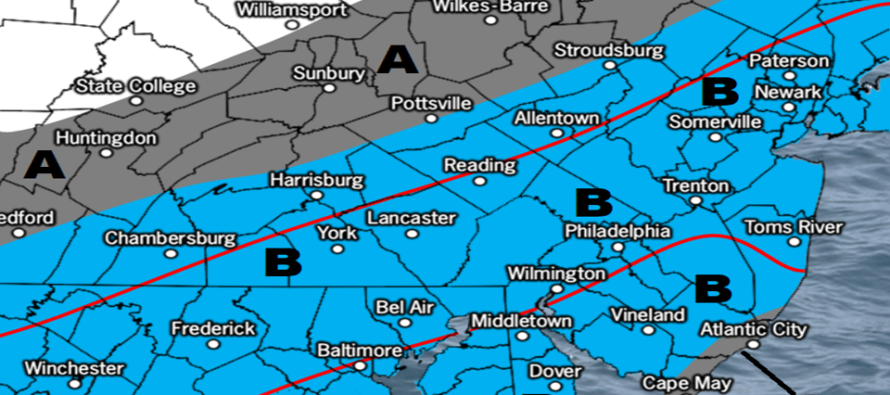
The below map represents our general thoughts on snow amounts tomorrow. Not a big event but an important one for the weekend potential. The current model consensus is that the Saturday snowstorm has slipped off to the S and E of NJ. The way it is now, SENJ would have the best chance for snow and NWNJ would have the worst. And that would be the northernmost extent of current guidance. We are still 72 hours away from that system however and need to see where the Arctic frontal boundary will ultimately come to rest (to the S/SE of NJ) by Friday morning…the very Arctic frontal boundary that will push through the precip tomorrow and change rain to snow.
The heaviest snow tomorrow (the jackpot – 2-4 inches) should occur right along the Arctic frontal boundary. Therefore, if the jackpot tomorrow ends up being through NNJ that means the front will have been hung up some. If SNJ sees tomorrow’s jackpot then that means the front made it through faster. The boundary will act as a steering force (highway) for Saturday’s low across the S Mid-Atlantic US. With that said, I’ll be closely watching the Arctic frontal boundary advancement as a forecasting tool for Saturday.
But if you needed a forecast for Saturday right not, it would be mostly a miss to the S and E of NJ with maybe some fringe snow showers scraping extreme SNJ/SENJ. This is because the models are suggesting a faster N stream of energy and slower S stream. The trough is therefore modeled to positive and progressive for the vorticity to kink back and turn the surface low further N. This upper-level setup is becoming more likely now (72 hours from the possible event). But where that Arctic front comes to rest could mean a SENJ hit or miss IMO. That’s where I’m at for Saturday. Need to get through tomorrow’s system first:
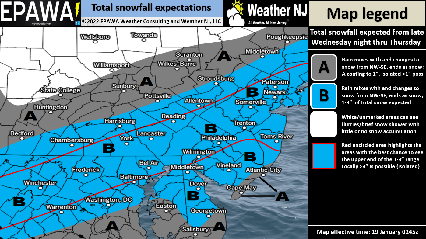
Full resolution snow impact map
In English: A light snow event is approaching New Jersey. It should move in overnight tonight as rain and change to snow around sunrise tomorrow (Thursday). It should then snow through the rest of tomorrow morning and wrap up by early afternoon tomorrow. Just keep in mind that NWNJ will be the first to change to snow and first to end while SENJ will be the last to change to snow and last to end. The above snow map represents our thoughts on expected amounts tomorrow. Even though it is a light snow event overall, there could be a solid thump of snow right after the rain-to-snow changeover which could time poorly with Thursday’s AM commute. Also initial rain could wash brine away from streets and provide an icy surface beneath the light snow accumulations. Just some things to consider for traveling. The Saturday storm looks like a S/E miss per the latest data but I haven’t completely written it off just yet. If the status quo is held through tomorrow’s system then I will likely write most of NJ off for snow aside from maybe SNJ/SNJ snow showers with light accumulations. Need to see how tomorrow pans out first (see above discussion). Either way, the very cold air mass will return after tomorrow’s snow and lead us into the weekend as the active wintry pattern continues. There are potential wintry systems almost every 3-4 days through the rest of January into February. I’ll check in later tonight when tomorrow’s precipitation is knocking on the door. Have a great rest of your Wednesday and be safe! JC
Download the free Weather NJ mobile app on Apple or Android. It’s the easiest way to never miss Weather NJ content. Our premium services go even further above and beyond at the hyper-local level.
Jonathan Carr (JC) is the founder and sole operator of Weather NJ, New Jersey’s largest independent weather reporting agency. Since 2010, Jonathan has provided weather safety discussion and forecasting services for New Jersey and surrounding areas through the web and social media. Originally branded as Severe NJ Weather (before 2014), Weather NJ is proud to bring you accurate and responsible forecast discussion ahead of high-stakes weather scenarios that impact this great garden state of ours. All Weather. All New Jersey.™ Be safe! JC


LOCAL FORECAST | INTERACTIVE RADAR | LATEST NJ WEATHER ALERTS | WEDDING FORECAST| PRIVACY POLICY
© Copyright 2026 Weather NJ LLC. All Rights Reserved.
Some information that can be found on our website is provided by a private weather station and is not an officially recognized station for weather reporting. Though we always strive to achieve accurate reporting for our own use, it is important that you do NOT depend on the data provided here for any purpose.
