

Light Snow Event Approaching
Discussion: Today was the last of the warmer afternoon-spiking days. A cold front will pass through overnight which will drop temperatures below freezing for many heading into the light snow event.
The data has trended a bit for the approaching light snow event. The heaviest axis of snow is now targeting NNJ/CNJ/SWNJ instead of SENJ. This has a few implications with it. This means that SENJ will likely remain warmer for longer. Despite a steep temp drop from mid-60s to mid-30s, SENJ might struggle to dip below freezing to allow accumulations. It means very little to nothing for SENJ tomorrow morning. If SENJ is going to see anything, it would be later Sunday afternoon/evening from the fringe of the coastal low. Only then would temps be cold enough for stickage in SENJ. It’s just not looking good for SENJ if you like snow.
The 95 corridor (from PHL to NYC) and about 20 miles on either side of it (NW and SE) is now modeled for 3-6 inches of snow to fall on shorter-range guidance. However, after the incredibly warm day (and recent period), the roads are going to take longer to chill to the point of stickage. So, our following snow map is mainly geared towards road accumulations, not how much could fall, and possibly stick to the grass. The section C of our map (jackpot snowfall axis) might see 3-6 inches of snow fall with only 1-3 sticking on roads. We figure that information is much more valuable for travel and safety. Most of that snowfall should occur between ~midnight tonight and early-afternoon (Sunday)
NWNJ would have an easier time accumulating since they are closer to the cold front and have elevations to consider. NWNJ therefore would have the best chance to exceed the general 1-3 expectation in roads.
SENJ could very well go mostly snowless Sunday AM and not see anything until closer to noon or after. It’s all about the surface line of freezing and how intense it crashes to the SE with the cold front. Right now, the line of freezing only makes it to near rt 70 with everyone SE of that hovering in the mid-30s. Heavier precipitation rates could help chill the surface but that is more of a possibility rather than a probability.
Either way, here’s our snow map and again, this is what we think for roads. Expect slightly higher amounts on the grass. The SENJ coastal situation will be an 11th hour call if it happens. Otherwise SENJ is looking at little-to-nothing at all.
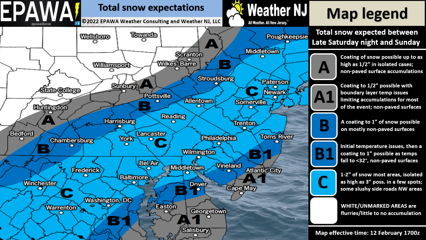
Click here for full-resolution snow map.
In English: Warmer temps today will drop after sundown and quite sharply. By sunrise tomorrow (Sunday), most should be at or below 32F with the exception of a decent chunk of SENJ. Snowfall will move in either just before or just after midnight tonight (depending on your location) and fall statewide (see above expected amounts on roads) through Sunday early-afternoon. It might be noon tomorrow or after before SENJ begins snowing. There’s a small possibility of a snowier than expected outcome for SENJ Sunday evening but I wouldn’t hold my breath and it would still likely fall short of a significant event. It would only make SENJ behave more like 95 and points NW. Otherwise, this is a light nuisance type event that was well-modeled for 9 days lol. Good luck everyone and please be safe! I’ll start some radar obs posts tonight when snow is approaching. JC
Jonathan Carr (JC) is the founder and sole operator of Weather NJ, New Jersey’s largest independent weather reporting agency. Since 2010, Jonathan has provided weather safety discussion and forecasting services for New Jersey and surrounding areas through the web and social media. Originally branded as Severe NJ Weather (before 2014), Weather NJ is proud to bring you accurate and responsible forecast discussion ahead of high-stakes weather scenarios that impact this great garden state of ours. All Weather. All New Jersey.™ Be safe! JC


LOCAL FORECAST | INTERACTIVE RADAR | LATEST NJ WEATHER ALERTS | WEDDING FORECAST| PRIVACY POLICY
© Copyright 2026 Weather NJ LLC. All Rights Reserved.
Some information that can be found on our website is provided by a private weather station and is not an officially recognized station for weather reporting. Though we always strive to achieve accurate reporting for our own use, it is important that you do NOT depend on the data provided here for any purpose.
