

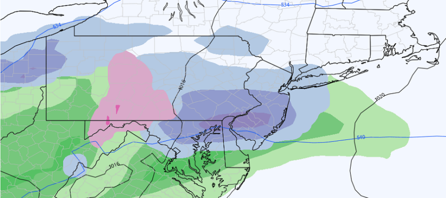
Light Snow Event Detected Sun PM-Mon AM
Discussion: Tonight, we’ll finally dip back into the low-30s for most areas, some below-freezing. It’s been a while (since right after Christmas) that we’ve seen such but it will feel more like winter and less like spring. We can thank a weak/transient trough swinging through for this, amidst a sea of positive upper-level height anomalies (a break in the ridging). This will set up a colder weekend overall but again, not brutally cold.
Saturday looks pretty good. Highs just into the lower-40s. Mix of sun and clouds. Maybe a little breezy out of the W/NW. Then overnight temperatures dip below freezing for most, if not all, of New Jersey. The weak/transient trough will be overhead on Saturday and already starting to move out.
Sunday could see a weak/transient ridge build during the day but it will likely not affect the colder theme of the weekend given it will be the front side of the ridge. Highs near-40 with mixed skies becoming cloudy for PM hours. A weak wave/upper disturbance will then push through late Sunday night through Monday morning. It’s not saying much, but it’s the best chance of snow, many in NJ, have had yet this winter. Temperatures will drop Sunday night cold enough to support snowfall and light stickage but we’re really only looking at a coating to an inch or two type of light snow event. The above cover image shows the initial thump of snow when precipitation first moves into the colder overnight air mass. By daybreak Monday morning, temps will rise above freezing and convert any remaining precip over to light rain before clearing. Roads will likely be fine. Natural surfaces could be a little white. Again, nothing serious.
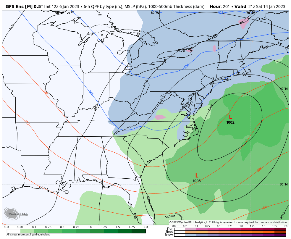
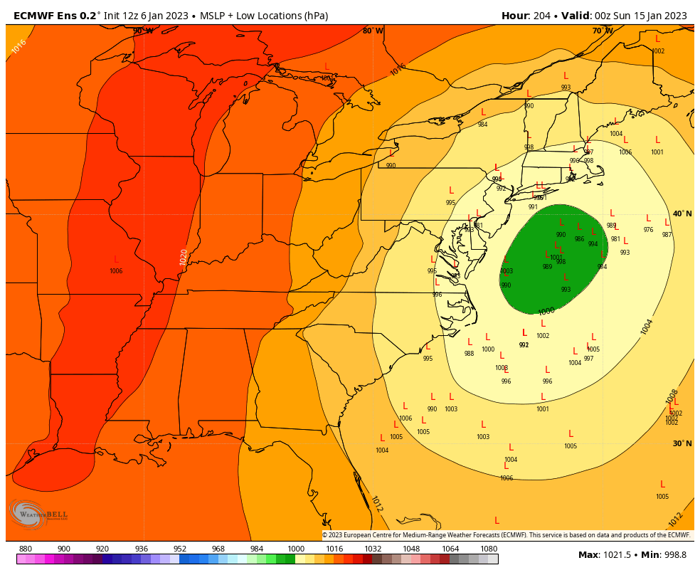
The January 11 coastal signal appears to be suppressed to the S by the mid-week cold next week (the cold to follow the Sun-Mon system). But this low could swing around to the N, once over the ocean, and set up a 50/50 (lat/lon) low that could help block/slow the Jan 13-15 strong storm signal. Additionally, there will be a block in Canada…not a Greenland block…but a block that should also slow down the storm. With that said, most of the Jan 13-15 weekend (Martin Luther King Jr. Weekend), could feature unsettled/stormy/windy conditions whether rain or snow. Snow vs rain is still too early to determine. The operational runs are all over the place but the ensembles like it. The below GFS image is generally a positive storm signal from this range. The European ensembles (second image below) are tightening their low center cluster towards the 40N/70W benchmark but still have a few warmer members on the NW side. But we still have a lot of time for this to go either way.
In English: Expect a colder weekend, but not brutally cold. A light snow event is then becoming more likely for Sunday night into Monday morning followed by a cold start to next week. Then all eyes turn to Jan 13-15 weekend for a stronger storm signal. Whether or not Jan 13-15 will be wintry or rainy is yet TBD. Clouds and wind are about the only assumption of any confidence from this range, given how strong the signal is. Serious tracking will begin Monday if still showing. Have a great weekend and please be safe! JC
Premium Services
KABOOM Club offers inside info forecast discussion, your questions answered, and early storm impact maps (ahead of the public). At 99 cents per month, it’s an extremely feasible way to show support.
My Pocket Meteorologist (MPM), in partnership with EPAWA Weather Consulting, offers professional/commercial interests, whose businesses depend on outdoor weather conditions (snow plowing, landscaping, construction, etc.), with hyper-local text message alerts/forecasts and access to the MPM premium forum—the most comprehensive and technical forecast discussion available for PA and NJ.
Jonathan Carr (JC) is the founder and sole operator of Weather NJ, New Jersey’s largest independent weather reporting agency. Since 2010, Jonathan has provided weather safety discussion and forecasting services for New Jersey and surrounding areas through the web and social media. Originally branded as Severe NJ Weather (before 2014), Weather NJ is proud to bring you accurate and responsible forecast discussion ahead of high-stakes weather scenarios that impact this great garden state of ours. All Weather. All New Jersey.™ Be safe! JC


LOCAL FORECAST | INTERACTIVE RADAR | LATEST NJ WEATHER ALERTS | WEDDING FORECAST| PRIVACY POLICY
© Copyright 2026 Weather NJ LLC. All Rights Reserved.
Some information that can be found on our website is provided by a private weather station and is not an officially recognized station for weather reporting. Though we always strive to achieve accurate reporting for our own use, it is important that you do NOT depend on the data provided here for any purpose.
