

Light Snow Event Developing
Discussion: This system has been beaten to death for almost 7 days now. While appearing much stronger at times on long-range model guidance, it remains modeled very weak and light over the past few days.
The cyclonic vorticity never evolved into a concise phased driver of a larger outcome. It always had the chance to, with all players on the field, but has not. There’s still too much of a positive and progressive trough influence to the steering currents of the coastal low. The dynamics remain modeled unorganized but with just enough interaction likely to make a little something happen.
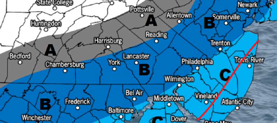
No official snow map today (for Sunday), just a rough sketch…
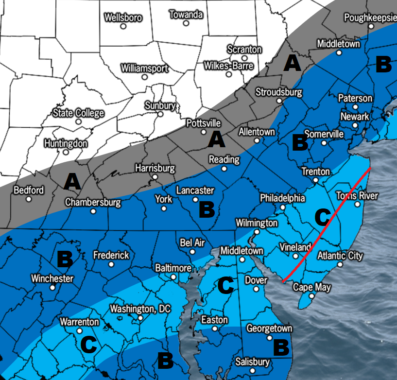
Area A would be flurries/not much at all. Area B would be a coating to an inch or two max. Area C would be a general 1-3” expectation with a red wildcard zone to the E of the red line. Most snow should fall Sunday between sunrise and early afternoon mostly from upper-jet dynamics enhancing lifting. However, areas E of the red line are closest to possible coastal development where the far NW edge of precipitation shield (from the weak low) could enhance snowfall a bit and produce more of a 2-4” outcome by the end of Sunday night/early Monday AM. This would be due to the N stream upper-level low digging a bit to the SW as it comes through the C US and in-turn raising heights slightly just offshore for the weak low to take a slightly closer track. It’s not a big deal but it could put the red area into a just-plowable situation rather than a nuisance light event. This is where I’m at now. I will have a more detailed snow map out tomorrow but you get it.
After the colder Sunday-Monday, the pattern should return to milder conditions for a while. Sure, there could be thread-the-needle events and transient cold snaps. But it might be March before anything big snow-wise is possible again. In the winter season baseball game analogy we’re in the 6th inning and do not expect much to happen in the 7th or 8th. The 9th would be march and we know how March can go (snowy like 2018 or mild). I take every 7 days at a time. But a long-range forecaster would probably tell you there’s not much room left for a big winter storm. We might actually be dealing with severe thunderstorm weather next week as a trough cuts through warm air but stays to our NW.
In English: Conditions will remain mild through tomorrow (Saturday) afternoon. Then expect temperatures to dive from near-60 Saturday afternoon to near-30 by midnight or just after. Temperatures should then continue to gradually fall through Sunday morning into the upper-20s as light snow breaks out by Sunday sunrise and ends by early Sunday afternoon for most. SENJ (the red wildcard area in my sketch above) could possibly hang on to snowfall later Sunday PM. Snow accumulations will do much better on natural/cold surfaces than traveled roads. But in general, this is a C-3 event from NWNJ to SENJ. Milder conditions return Tuesday-forward with maybe even some wind/thunderstorm potential next week. Have a great Friday night and please be safe! JC
Download the free Weather NJ mobile app on Apple or Android. It’s the easiest way to never miss Weather NJ content. Our premium services go even further above and beyond at the hyper-local level.
Jonathan Carr (JC) is the founder and sole operator of Weather NJ, New Jersey’s largest independent weather reporting agency. Since 2010, Jonathan has provided weather safety discussion and forecasting services for New Jersey and surrounding areas through the web and social media. Originally branded as Severe NJ Weather (before 2014), Weather NJ is proud to bring you accurate and responsible forecast discussion ahead of high-stakes weather scenarios that impact this great garden state of ours. All Weather. All New Jersey.™ Be safe! JC


LOCAL FORECAST | INTERACTIVE RADAR | LATEST NJ WEATHER ALERTS | WEDDING FORECAST| PRIVACY POLICY
© Copyright 2026 Weather NJ LLC. All Rights Reserved.
Some information that can be found on our website is provided by a private weather station and is not an officially recognized station for weather reporting. Though we always strive to achieve accurate reporting for our own use, it is important that you do NOT depend on the data provided here for any purpose.
