

Long-Range WeatherTrends360 Outlook

It’s time to harness WeatherTrends360 technology and look at how the rest of October 2020 should play out. WeatherTrends360 algorithms are documented with an 84% verification rate and are based on oceanic water cycles, time table series and very complex mathematics. The best takeaway from this data are general trends (cool vs warm, rainy vs dry, etc). I’m always hesitant to forecast specific surface conditions (rainfall amounts, snowfall amounts, winds, etc) beyond the 7 -day forecasting period. But general temperature and precipitation trends are what WeatherTrends360 does best with their proprietary mathematical analysis derived from over 150 years of reactive pattern data. For this reason, let’s call this a long-range discussion of reasonable expectations rather than a locked-in long-range forecast. You’ll never see me commit to specific surface conditions outside of the 7-day forecasting period.

The following diagram is calculated using WeatherTrends360 proprietary algorithms for New Jersey in general. Please keep in mind that micro-climate influences can vary. NWNJ elevations and SNJ Pine Barrens (away from the ocean), for example, will verify slightly colder than illustrated due to elevation and soil heat exchange. Interior CNJ/SNJ (closer to N Delaware/Philly/Trenton – I-95 corridor into NENJ) slightly warmer than illustrated due to urban heat island effect and several other influencing factors. All areas of NJ however would have similar graph trends and sky conditions. It’s best to let the following graph paint an overall picture (trends) instead of focusing on the low-level specific condition details.
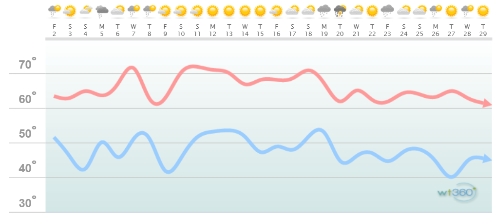
Discussion: This weekend (Oct 2-4) looks cool and dry once today’s clouds and sprinkles clear out. We’ll then see a slight warming early next week (Oct 5-7) associated with a small piece of tropical energy breaking off and sliding up the coast. A strong cold front is then modeled to move through for Thursday into next weekend. We’re talking about afternoon highs struggling to break 60 and overnight lows into the 30s for many areas. All of this modeled activity for the next week or so is clearly reflected by the WeatherTrends360 algorithms. Beyond that we’ll moderate some but continue the steady downtrend of average temperatures as we head into November.
Precipitation appears below-average for October. We’re to the point where frontal rain is fading out and synoptic system rain will be much needed. I’ll keep an eye out for any synoptic rain systems that form but I see none in the next week or so. The WeatherTrends360 algorithms seem to like Oct 19-23 for an unsettled rainy period. Other than that, they are predicting dry conditions in general.
We’re over the peak of hurricane season but October still needs to be watched for anything that forms in the Caribbean and tracks N into the W Atlantic Ocean. Those are the ones that can cause trouble for NJ with a perfect upper-level setup. None of that is currently showing but again, let’s just not dismiss the season completely until we close out October. Nor’easter’s become much more common in October-November than any tropical cyclone threats.
Other things to watch… The ocean is cooling but not as fast a land temperatures. Therefore any onshore flow between NE and SE flow can create tight thermal gradients between 70-degree ocean air mass and plunging overnight lows below-60. Fog becomes much more common this time of year as warm ocean air mass saturated cooler/drier air mass over land. Finally, the ECNJ and SENJ coastal areas can expect a generally warmer October than areas inland and especially in the NNJ elevations.

In English: Aside from a slightly anomalous mild start to next week (Oct 5-7) and a cold end to the week (Oct 8-11), October should feature near-average temperatures with below-average precipitation. No tropical threats or coastal storms are currently expected but I’ll be watching for any that materialize and will report accordingly. Have a great October and please be safe! JC
Jonathan Carr (JC) is the founder and sole operator of Weather NJ, New Jersey’s largest independent weather reporting agency. Since 2010, Jonathan has provided weather safety discussion and forecasting services for New Jersey and surrounding areas through the web and social media. Originally branded as Severe NJ Weather (before 2014), Weather NJ is proud to bring you accurate and responsible forecast discussion ahead of high-stakes weather scenarios that impact this great garden state of ours. All Weather. All New Jersey.™ Be safe! JC


LOCAL FORECAST | INTERACTIVE RADAR | LATEST NJ WEATHER ALERTS | WEDDING FORECAST| PRIVACY POLICY
© Copyright 2026 Weather NJ LLC. All Rights Reserved.
Some information that can be found on our website is provided by a private weather station and is not an officially recognized station for weather reporting. Though we always strive to achieve accurate reporting for our own use, it is important that you do NOT depend on the data provided here for any purpose.
