

Long-Range WeatherTrends360 Outlook

It’s time to harness WeatherTrends360 technology and look at how the rest of July 2020 should play out. WeatherTrends360 algorithms are documented with an 84% verification rate and are based on oceanic water cycles, time table series and very complex mathematics. The best takeaway from this data are general trends (cool vs warm, rainy vs dry, etc). I’m always hesitant to forecast specific surface conditions (rainfall amounts, snowfall amounts, winds, etc) beyond the 7 -day forecasting period. But general temperature and precipitation trends are what WeatherTrends360 does best with their proprietary mathematical analysis derived from over 150 years of reactive pattern data. For this reason, let’s call this a long-range discussion of reasonable expectations rather than a locked-in long-range forecast. You’ll never see me commit to specific surface conditions outside of the 7-day forecasting period.

The following diagram is calculated using WeatherTrends360 proprietary algorithms for New Jersey in general. Please keep in mind that micro-climate influences can vary. NWNJ elevations and SNJ Pine Barrens (away from the ocean), for example, will verify slightly colder than illustrated due to elevation and soil heat exchange. Interior CNJ/SNJ (closer to N Delaware/Philly/Trenton – I-95 corridor into NENJ) slightly warmer than illustrated due to urban heat island effect and several other influencing factors. All areas of NJ however would have similar graph trends and sky conditions. It’s best to let the following graph paint an overall picture (trends) instead of focusing on the low-level specific condition details.
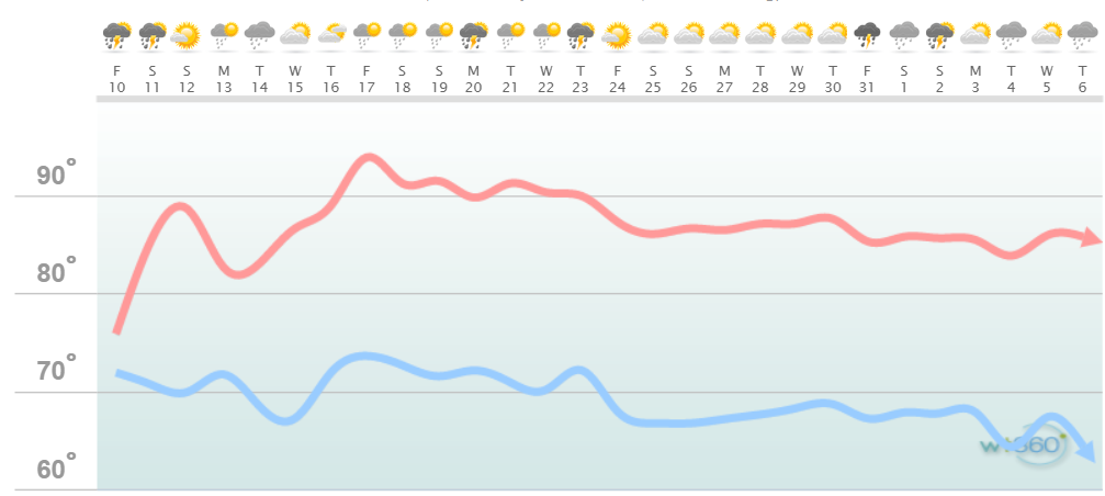
Discussion: As you can see we have another warm and humid weekend followed by a slight relaxation in temperatures and dew points this coming Monday-Wednesday (July 13-15). From Thursday (July 16) until about July 23 it looks like the heat is on. In this period I expect heat indices of 100+ especially for the warmer locations of NJ away from the ocean. From July 24-forward it looks like we will begin our annual decline in average temperatures (just over the hill). While this may be true at a macroscopic level you can never rule out heat waves in August and September where 3-? days in a row get pretty hot. We’ll have to watch for those as they approach in the mid-range forecasting period. Another wildcard to consider is the start of the Atlantic tropical season. July is typically a dormant month like June but it is closer to the peak season and we’ll have to watch any tropical disturbance that pops up. The chances for this increase significantly for August.
In English: Expect another warm and humid weekend, a slightly less-warm Monday-Wednesday then some good old July heat from July 16 to about July 24. After that temps start falling for the year. Precipitation appears to be average for the rest of July and will mostly be from frontal showers and thunderstorms. Any synoptic systems will have to be detected in the short-to-medium range forecasting period. Please stay as cool and hydrated as possible over the next few weeks. Enjoy the rest of your July and please be safe! JC
Jonathan Carr (JC) is the founder and sole operator of Weather NJ, New Jersey’s largest independent weather reporting agency. Since 2010, Jonathan has provided weather safety discussion and forecasting services for New Jersey and surrounding areas through the web and social media. Originally branded as Severe NJ Weather (before 2014), Weather NJ is proud to bring you accurate and responsible forecast discussion ahead of high-stakes weather scenarios that impact this great garden state of ours. All Weather. All New Jersey.™ Be safe! JC


LOCAL FORECAST | INTERACTIVE RADAR | LATEST NJ WEATHER ALERTS | WEDDING FORECAST| PRIVACY POLICY
© Copyright 2025 Weather NJ LLC. All Rights Reserved.
Some information that can be found on our website is provided by a private weather station and is not an officially recognized station for weather reporting. Though we always strive to achieve accurate reporting for our own use, it is important that you do NOT depend on the data provided here for any purpose.
