

Major Hurricane Ian to hit Florida. NJ Impacts Pushed Back.
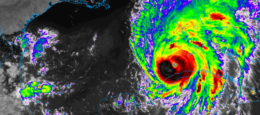
Discussion: Before discussing New Jersey impacts, let’s get up to date on Ian’s current situation. Ian’s eye has just emerged into the SE Gulf of Mexico after passing over W Cuba this morning. Ian will now try to follow the current departing trough over the E US, especially as high pressure bears down on it from the Great Lakes. This high pressure is leading an approaching ridge for the E US. Therefore Ian will want to turn to the NE now and likely make landfall somewhere between Sarasota, FL and Sanibel Island, FL on FL’s west coast sometime between Wednesday afternoon and evening (tomorrow). It doesn’t look good as Ian could still be a major hurricane during that landfall. It’s important to note that the trend in model guidance has been further E and S into a more southern part of Florida. If that continues then we could possibly see Ian emerge over the Atlantic just off GA/SC. This is something I am monitoring. For now, this analysis is off a blend of today’s model guidance and real-time observations.
Right now, just N of W Cuba, Ian is a category 3 major hurricane and given the satellite look, could intensify to a 4 IMO. Ian will be over very warm water with low shear for another 12-18 hours before starting its approach towards the W FL coast. That is enough time to develop further. However, once Ian 1) begins interacting with land and 2) starts to encounter the high pressure/ridge resistance from the N/NW, Ian should weaken. We might see a major cane weakening to a cat 2 at the time of, or just after, landfall which is still a dangerous situation. Our thoughts are with you down there. Please respect hurricane evacuation orders and local guidance from official local authorities. Folks in that area are subject to life-threatening storm surge and destructive winds. Most impact away from that central W FL coastal area will be heavy rainfall and still-damaging, but not catastrophic, winds.
Ian will likely then continue NE a little before turning back to the NW once missing the trough connection and getting stuck under the approaching ridge (with leading high). This could bring the center of circulation near the Orlando area on Thursday. At that point, Ian should be down to a cat 1 or strong tropical storm so nothing the area hasn’t seen before and nothing like what the central W coast of Florida is in for tomorrow night (Wednesday). From The Orlando area on Thursday, Ian’s remnants would then likely push NW into GA before turning towards the S Mid-Atlantic US by this weekend. With that said, Ian’s remnant rainfall and moderate winds would likely hold off for NJ through Saturday and then move in either late Saturday night or early Sunday. It could then be a rainy/breezy period from Sunday-Tuesday in NJ. As of right now, it doesn’t look like a tornado situation but could be a flash flooding situation. Let’s get through Ian’s FL landfall tomorrow before assessing NJ impacts later this weekend.
Regardless of how “remnant” the rain and wind will be for New Jersey, I am starting to become a little concerned for coastal flooding in the Delaware Bay, ECNJ/SENJ coasts, and Raritan Bay areas. It looks like a prolonged period of onshore flow will begin Friday for these areas and possibly not end until Tuesday. Therefore we could have a series of high tides occurring with backed up ocean and heavy rainfall on top. Astronomical tides will be between new and full moon influence so a little help there. But the rain and wind-driven surge should put some water in the streets.
In English: Hurricane Ian is a beast and will likely mess up the central W FL coast pretty good tomorrow afternoon-evening (Wednesday). Ian will then meander in the SE US and eventually bring rain and at least breezy winds to NJ later this weekend. Ian could still trend further S in Florida so I am actively monitoring the data tonight/tomorrow morning. But onshore flow should start Friday/Saturday but the rain should hold off until Saturday night/Sunday morning and last possibly into Tuesday. The prolonged period of onshore flow could lead to coastal flooding for ECNJ/SENJ immediate coastal regions from Saturday PM to Tuesday PM. Let’s see how everything looks tomorrow. Have a great rest of your Tuesday and please be safe! JC
Premium Services
KABOOM Club offers inside info forecast discussion, your questions answered, and early storm impact maps (ahead of the public). At a buck per month, it’s an extremely feasible way to show support.
My Pocket Meteorologist (MPM), in partnership with EPAWA Weather Consulting, offers professional/commercial interests, whose businesses depend on outdoor weather conditions (snow plowing, landscaping, construction, etc.), with hyper-local text message alerts/forecasts and access to the MPM premium forum—the most comprehensive and technical forecast discussion available for PA and NJ.
Jonathan Carr (JC) is the founder and sole operator of Weather NJ, New Jersey’s largest independent weather reporting agency. Since 2010, Jonathan has provided weather safety discussion and forecasting services for New Jersey and surrounding areas through the web and social media. Originally branded as Severe NJ Weather (before 2014), Weather NJ is proud to bring you accurate and responsible forecast discussion ahead of high-stakes weather scenarios that impact this great garden state of ours. All Weather. All New Jersey.™ Be safe! JC


LOCAL FORECAST | INTERACTIVE RADAR | LATEST NJ WEATHER ALERTS | WEDDING FORECAST| PRIVACY POLICY
© Copyright 2026 Weather NJ LLC. All Rights Reserved.
Some information that can be found on our website is provided by a private weather station and is not an officially recognized station for weather reporting. Though we always strive to achieve accurate reporting for our own use, it is important that you do NOT depend on the data provided here for any purpose.
