

Major New Jersey Snow Storms
Lets travel back in time and check out some major snow storms that have affected New Jersey in the past. But first, lets talk about the unique geological and climatological features that have contributed to these major New Jersey snow storms. New Jersey is positioned so that when mid-latitude cyclones in the northern hemisphere (low pressure systems) take a certain track in the colder months, they result in major New Jersey snow storms. That certain track generally spans from the Outer Banks in North Carolina to the area known as the benchmark just south of E. Long Island (40N/-70W).
When a low pressure center passes through that general area, it usually means warmer moisture has been tapped from the sub-tropical jet stream. Dependent on polar/Arctic frontal interaction, cold air mass is pulled into the synoptic storm system—creating a natural snow making machine to the N and W of the coastal storm center. The precipitation shield on radar forms a visual “comma head” or “shark tooth” and New Jersey shuts down for a bit. This perfect setup rarely happens (a few times per decade) but when it does it becomes a historical memory. Lets look at some of these major New Jersey snow storms over the last 65 or so years…
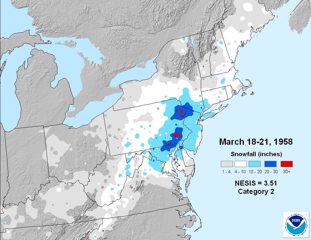
March 18-21, 1958
d
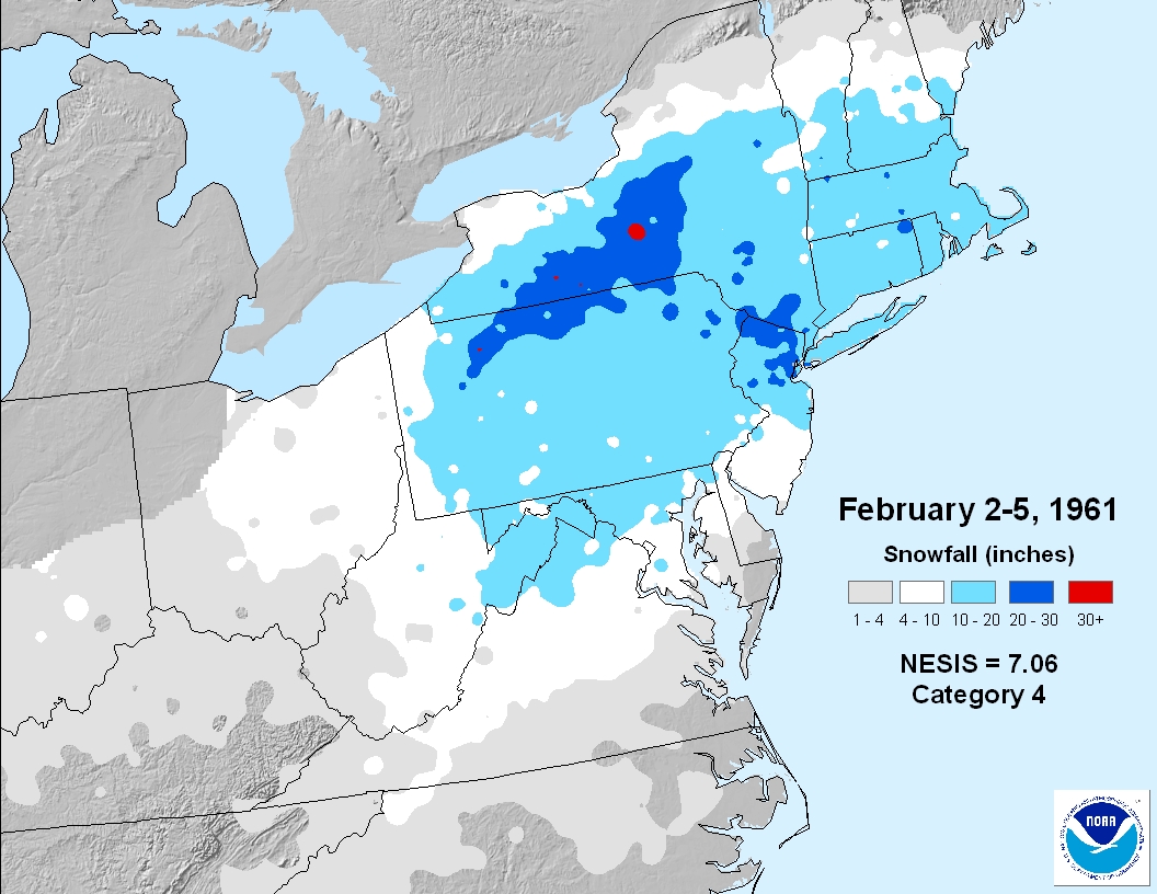
February 2-5, 1961
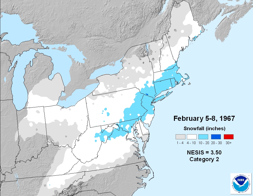
February 5-8, 1967
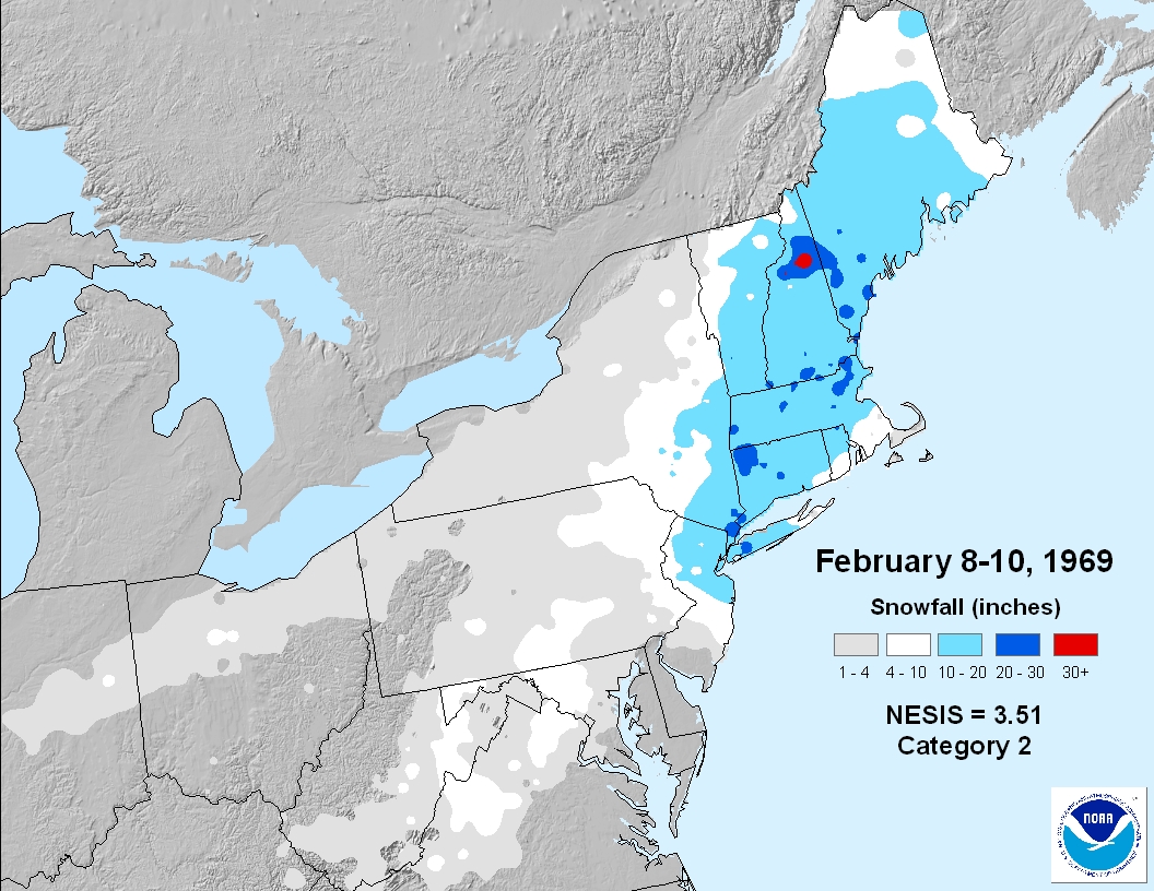
February 8-10, 1969
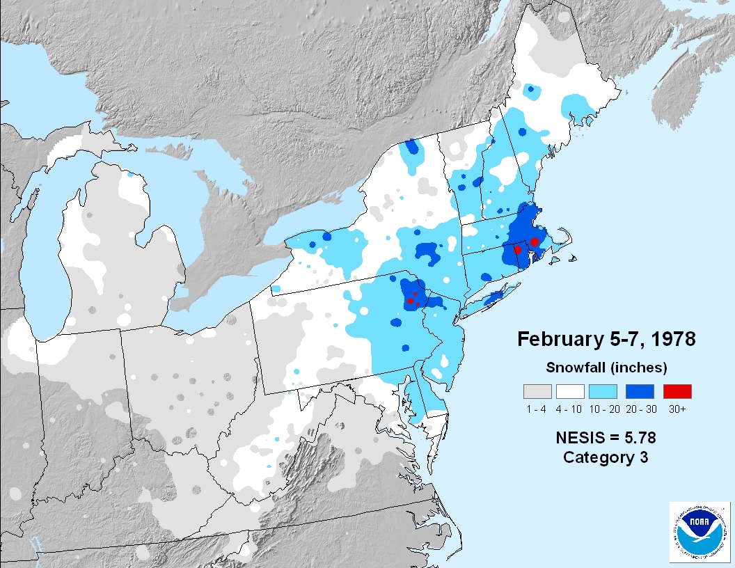
February 5-7, 1978
April 6-7, 1982
![-b49926f05c3d2768[1]](http://www.weathernj.com/wp-content/uploads/2014/10/b49926f05c3d27681.jpg)
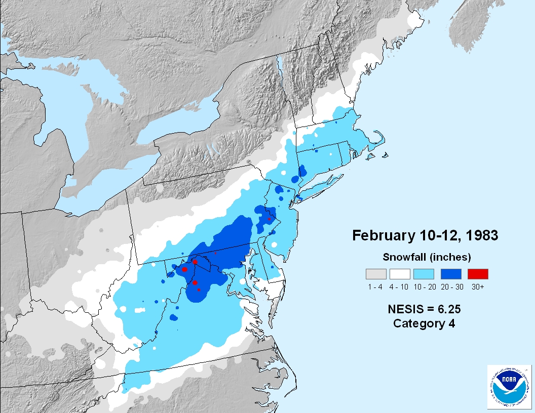
February 10-12, 1983
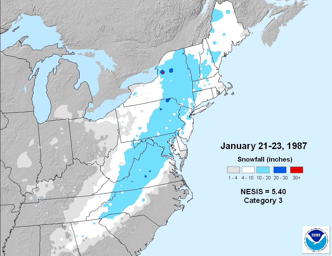
January 21-23, 1987
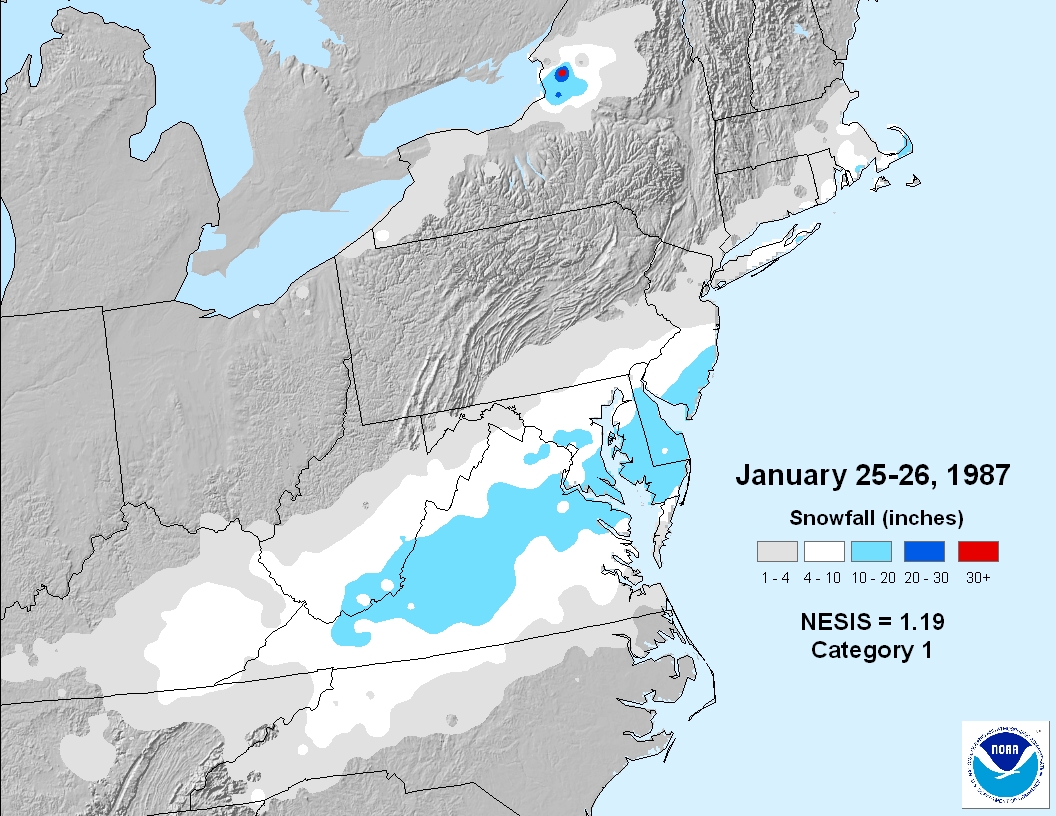
January 25-27, 1987
March 12-14, 1993 (the superstorm)
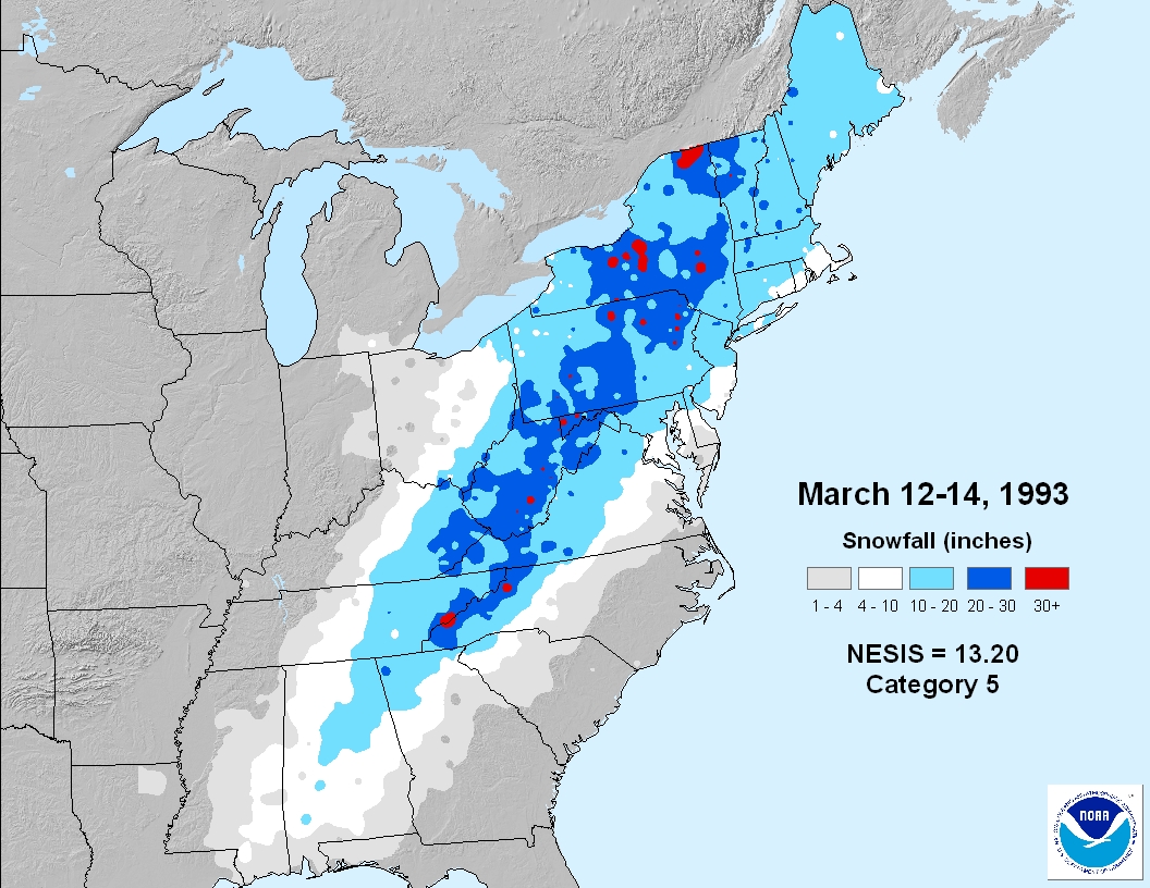
I’ll add some context from hereon, since it was one of the first snow storms I can remember. We had all woken after staying overnight at my friends house for his birthday weekend. It was the first time for me that big snow happened so late in the winter. Being in SENJ for the storm system, we were on the warmer side and still got a foot of wet snow. It was a quicker melt but amazing to see. Had I had access to the resources and knowledge I have now, back then, I would have been freaking out at the physics and dynamic setup.
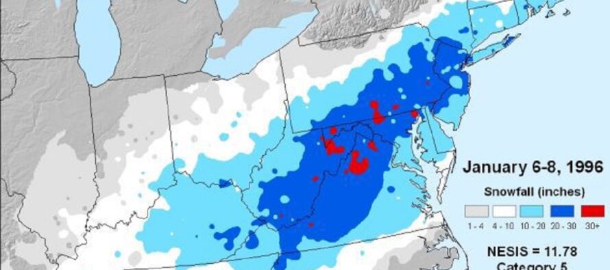
January 6-8, 1996 (my personal favorite)
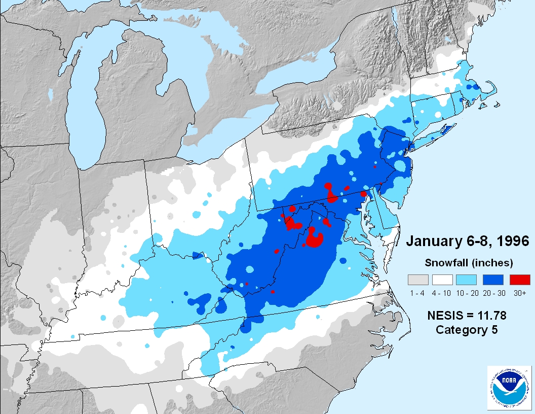
This storm system produced the most memorable amount of disruption to my town (in southern Ocean County). It happened on the weekend and shut everything down for the entire following week. School was closed (I was in high school) and we were all buried with 20-24 inches of snow in a brutally cold Arctic air mass. There was still snow on the ground in February from this system. I remember temperatures being very cold leading into this system…like in the upper-teens for high the Friday before. It started flurrying Friday morning and gradually built into a steady light snow by Friday night, then a steady moderate snow by Saturday, lastly a steady KABOOM rate of snow Saturday into Sunday.
February 15-18, 2003 (Presidents’ Day Weekend)
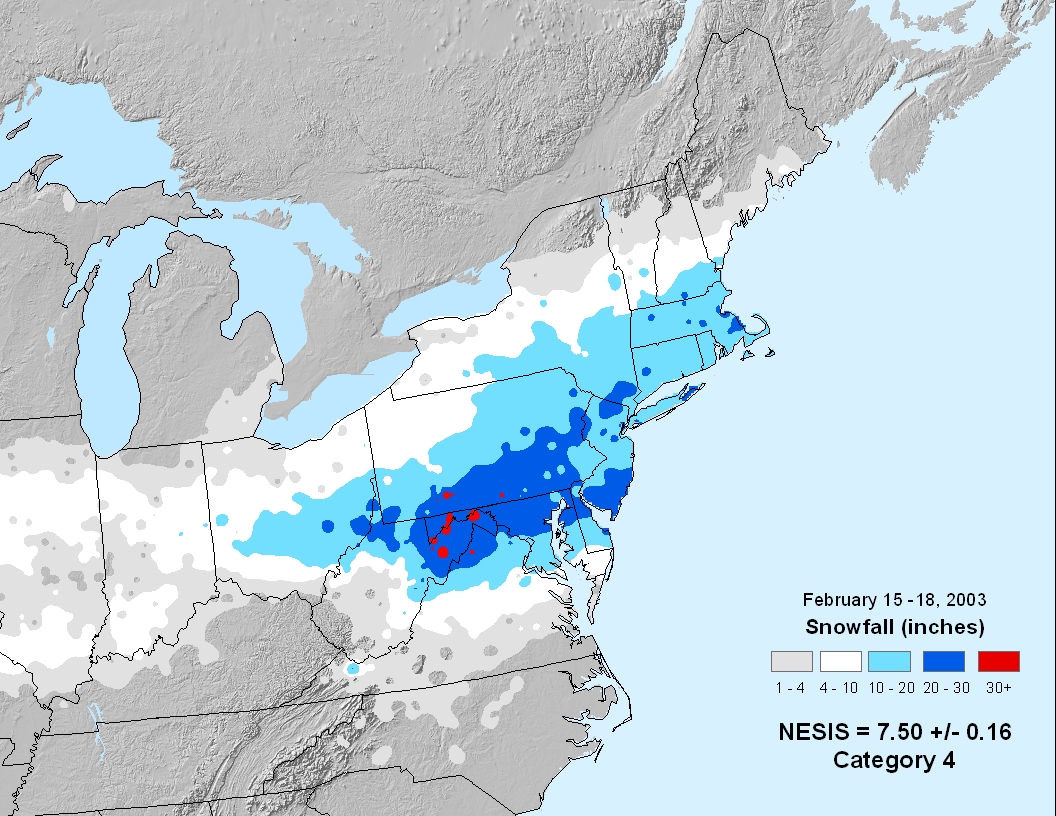
I was a little older for this one (in my early-20s). But it was the most snow I’ve ever seen for S Ocean County. We had somewhere between 22-28 inches. I actually had to drive from the Catskills in NY to SENJ as this system was ending. Luckily, somehow, the NY Thruway and Garden State Parkway had 1-2 lanes plowed. It took a while but when we arrived home, it was a “Dude where’s my car?” situation for our entire area.
February 12-13, 2006
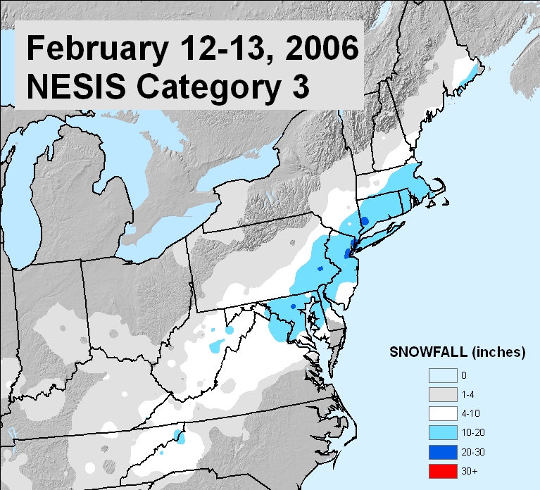
I’m not going to lie. I don’t remember this one that well. I think it was a snow-to-rain situation for me in Ocean County but obviously other parts of NJ did much better. If I recall, we went trailing in the Pine Barrens, played a game of snow football, and then returned home to rain. That’s about it though.
December 18-21, 2009 (storm 1 of historical winter)
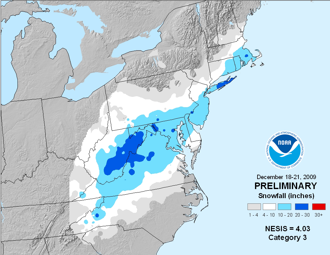
This storm launched my online weather thing. I remember every model and weather outlet wrote it off until 12 hours prior to the event. It was a coastal that trended E out to sea then returned W in the 11th hour. One of those “play the old GFS progressive bias and old Euro overamplification bias.” 24 hours before the event, I saw the start of the trend and issues a “foot of snow likely tomorrow” the night before on my personal Facebook page. 18 inches later and people were telling me to start a Facebook business weather page on Facebook. Ok… here we are.
February 4-7, 2010 (storm 2 of historical winter)
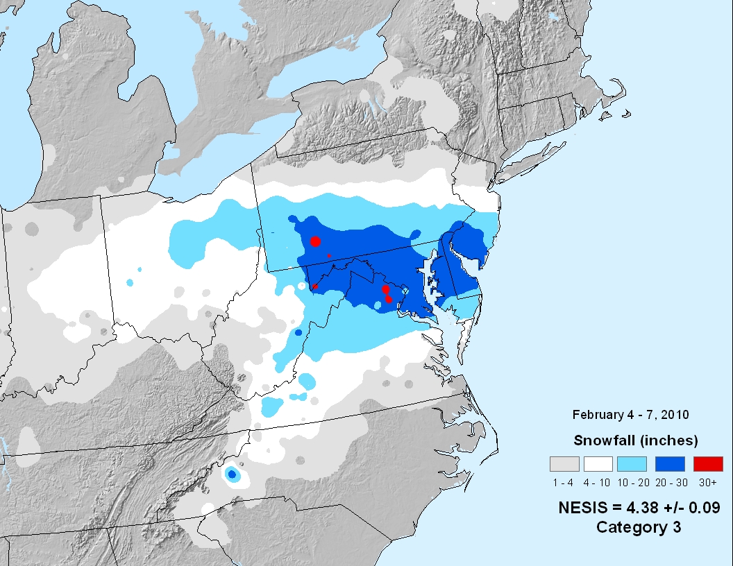
The two back-to-back 12-18 inch snowstorms of early Feb 2010 were relentless, especially for the folks who were overlapped into seeing jackpot from both. I remember areas like Brick, NJ saw 24-36 from both in total. After coming off the Dec 2009 storm, it had already been a historical winter in the making.
February 9-11, 2010 (storm 3 of historical winter)
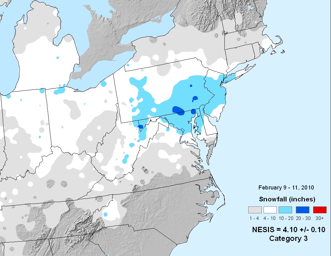
This was the second of the back-to-back systems in early Feb 2010. I remember hitting a pothole shortly after this one (plow generated) which popped both my passenger-side tires. Having only one spare made for an interesting time.
February 23-28, 2010 (storm 4 of historical winter)
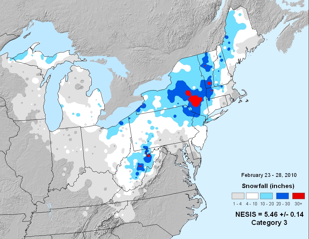
This 4th major snowstorm of the historical 2009-2010 winter missed my area for the most part. I think we saw 3-6 inches of snow that transitioned to a rain meltaway. But NNJ and especially the Catskill region of New York were absolutely crushed. Way beyond KABOOM and even beyond a Dude, where’s my car? This one was biblical for SE NY/NNJ.
December 24-28, 2010 (The Boxing Day Blizzard)
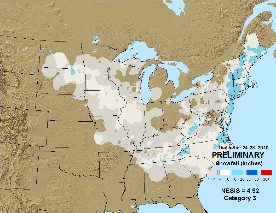
Unfortunately I was out of state visiting family for this one. I had a great time with my family but had to see the pics of snow halfway up everyone’s door without experiencing it. A bittersweet trip to Florida. Anyway, this was a coastal crush job that brought much more snow to ENJ than WNJ. Parts of ENJ saw 30 inches from this while places like Philly saw 3-6 inches. A very sharp cut-off from E to W. But one for the books (and blogs).
January 26-27, 2011 (The I-95 Snowstorm)
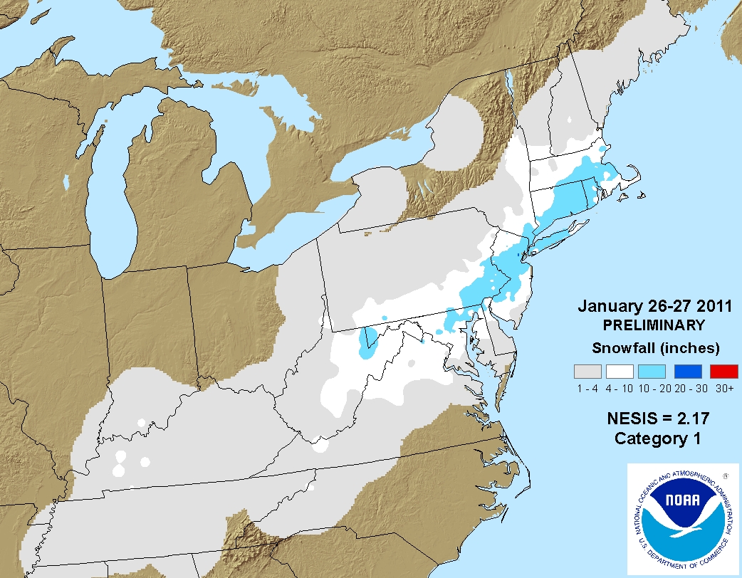
This storm happened when I lived in Maryland temporarily. We saw the same amount in Maryland that New Jersey saw. This combined with the previous winter made for the most historical snow period in modern NJ history (starting with Dec 2009 and ending with this one – 6 major NJ snowstorms in 14 months). This brought the historic period to an end.
October 29-30, 2011 (The Halloween Snowstorm)
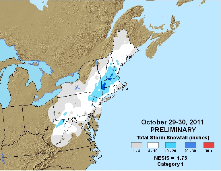
This system was so out of place and so out of line, it probably made your in-laws jealous. It didn’t do much for my area in Ocean County (SENJ) but it did end with a light snow accumulation, which in October is kind of nuts. It did much better for NWNJ. I remember being on this storm from day one though. It doubled my social media following at the time. But it also opened up an almost-snowless period that lasted until Nemo in 2013.
February 7-10, 2013 (Nemo)
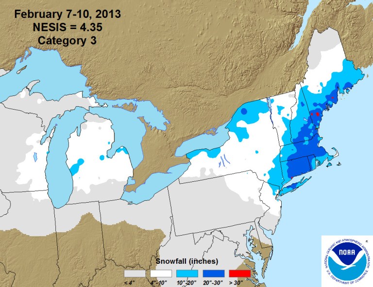
This storm system also didn’t do much for my area but it hit NENJ pretty good as temps crashed behind a departing coastal low. It brought lots of snow lover hope back after the nearly-snowless period surrounding Superstorm Sandy. It went on to crush New England a lot harder than NJ.
February 11-14, 2014 (the baby maker Kaboom)
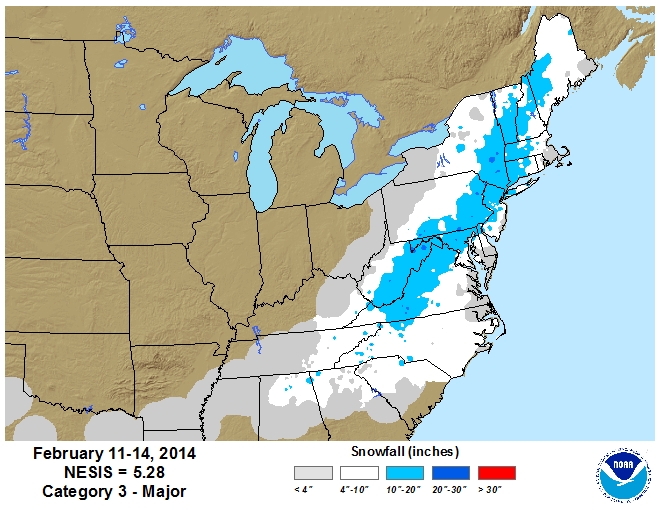
Winter of 2013-2014 was historic from a temperature point of view. This was the most severe Arctic cold outbreak we’ve seen in recent history. A huge lobe of the Polar Vortex broke off and parked over interior SE Canada and the N/C US. The Polar Vortex energy amplified a few lows rounding the trough on the lower jet. When this happens, lows tend to blow up and dump snow. The Polar Vortex energy just has magical amplification status with high-ratio snow outcomes. There were several snow events during this winter but nothing crippling. The cold was a bigger story. December opened up with a foot of snow on Dec 13. Remember the Eagles game? I had to drive from NJ to Maryland in that. Then we had another 10-12 inch job around New Years, followed by the Polar Vortex outbreak through January into February. Remember when low temperatures ranged from negative 20 to negative 5 from NNJ to SNJ? Yeah, that was rough. Then we arrive at the above pictured storm (right before Valentines Day), the higher impact snowstorm of the season. We then had several 4-8 inch events that March of 2014. An incredible winter!
January 22-24, 2016 (the NNJ “Dude, where’s my car?” snowstorm)
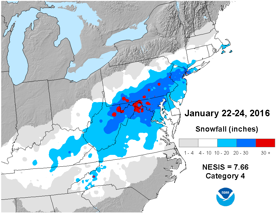
This storm was bittersweet for me. First of all, it was an El Nino winter. An overall mild winter with temps commonly pushing into the 50s and even 60s at times. Most snow lovers had given up by early January on seeing any snow the rest of the winter. This is an example of when a thread-the-needle situation happens. A perfect situation met the perfect circumstances. Almost all of the US were under lower height fields for a week. We had a short window of Greenland blocking…and mother nature took advantage of it by spinning up a slowly moving 970mb low that ejected S of OBX and traveled SE of the benchmark. Yet it still threw a massive historic snow band across EPA and NNJ. The storm itself was incredibly strong over the ocean. Remember that cruise boat that tried to say no one knew about the storm? Anyway, this was another weekend system for my area (SENJ). 6 inches of powder fell Friday night and we woke up to a foot Saturday morning. Then from Saturday morning to Saturday night, it rained at 33 degrees…knocking down the 12 inches total to about 8 by Saturday night. It then turned back into powder snow and dropped another 6 inches. We ended up with a measurement Sunday morning of about 12-14. But we would have saw 18-24+ had the line of freezing stayed 10 miles to the SE of where it pushed into. This was so ridiculous/funny/sad, it actually spawned a weather organization called 33 Degrees and Rain. But it was a historic crush job in the middle of a warm winter. A very fast melt but tons of icing issues during the melt. I remember shoveling this snow was like pushing slurpee ice around the yard…if you could break through the ice layers within the snowpack.
January 3-5, 2018 (Coastal KABOOM)
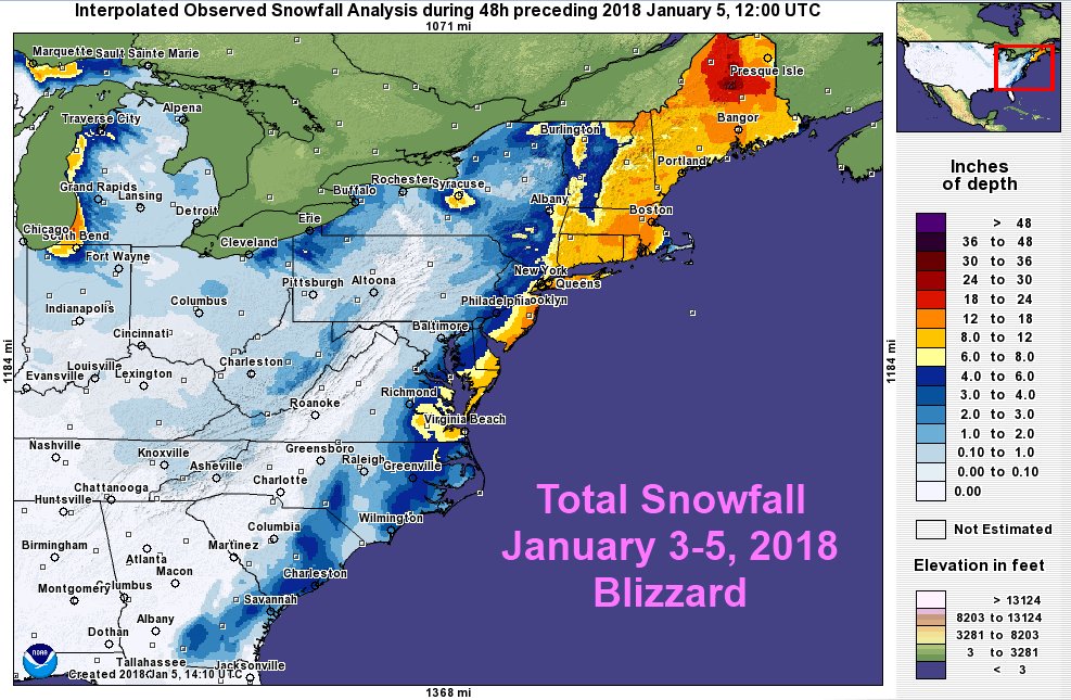
This storm system had vibes of the Boxing Day Blizzard in the sense of crushing ENJ and leaving WNJ wanting. It was a smaller scale than Dec 2010 though. Only 12-18 not 30+ inches. It was a pure coastal snowstorm though. I remember taking a walk in the heavier 30+ dbz bands thinking about how I could feel the ocean in it…unlike snow that approaches over land from the NW/W/SW. The snowflakes were low-ratio and pelting on my jacket. But at 30-31 degrees is was falling fast and sticking. This system was followed by a ~two week period where temperatures failed to climb above freezing even during afternoon high. This kept the snowpack around for a while. It wasn’t Winter 2013-2014 cold, but it was the second coldest period of duration that I remember in modern NJ weather history.
March 2018 (The Four Nor’easter Month)
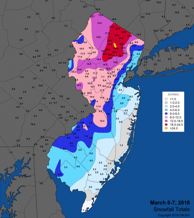
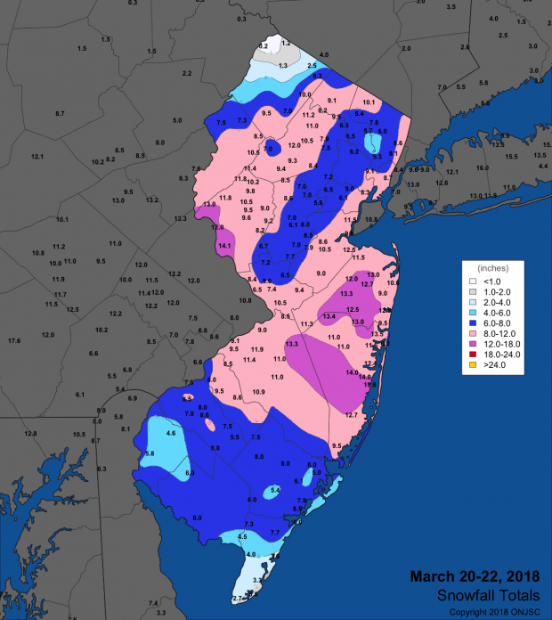
Just a few months after the early January 2018 coastal snow storm, New Jersey saw the wintriest March I can remember. Four (4) nor’easters brought snow to various parts of New Jersey. Two of them were significant snowstorms (no slouch). But the other two (pictured just above) qualified for major impact criteria at least regionally. The left image represents the nor’easter that targeted NNJ/NENJ on March 6-7, 2018 and the right image represents the nor’easter that hit ECNJ the hardest on March 20-22, 2018. If you consider the snowfall of all four nor’easters that March of 2018, most of NJ saw significant-to-major snowfall. The snow was very wet/low-ratio. I remember lots of tree limbs snapping when the snowfall ended. This, along with the early January 2018 snowstorm, made Winter of 2017-2018 one to remember.
December 16-17, 2020
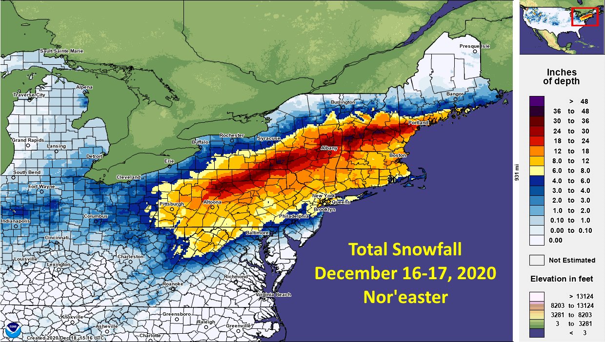
This snowstorm was a disappointment for most areas S of I-78. But for areas N of I-80, especially the higher elevations, many clocked 12-18 inches of snow. Non-historic but high impact as a major snowstorm that ultimately jackpotted the Catskills into New England. First snowstorm of the COVID pandemic. Poor students, now that we live in the remote world, they’ll never know snow days as we once did.
January 30-February 2, 2021
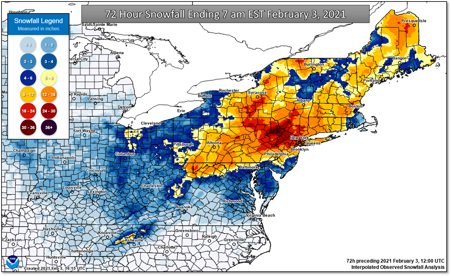
This was the second snowstorm of the heart of the COVID pandemic. This one brought big snows to areas further S in NJ than the December 2020 storm did. Several locations across NNJ (mainly N of I-78) clocked snow accumulations in excess of 20 inches, some 24 forcing the “Dude Where’s my Carr?” status. SNJ missed out on the heavier snows but certainly made up for it the following winter.
January 27-29, 2022 (SENJ Snowstorm)
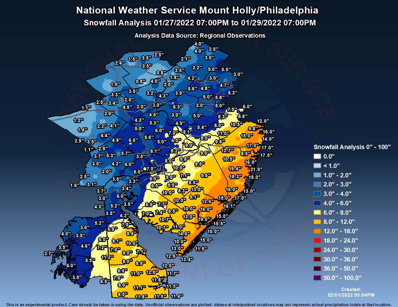
This snowstorm is the most recent major snowstorm for New Jersey. Outside of this, most of CNJ and SNJ haven’t seen a major snowstorm since January or March of 2018 (we all got hit that winter). This snowstorm targeted ECNJ/SENJ and hit such pretty well overnight. I woke up to 17-18 inches across my yard and my daughter had a blast playing in it. My distinct memory was that the snow was too high-ratio and powdery to form adequate snowballs. Making a snowman was impossible because of that. A few days later, after some meltage, and we were doing just fine with snowballs and snowmen.
So where where you when these major New Jersey snow storms happened? What were you doing and how did they affect you? Please, if you wish, share your experiences and feel free to use this article whenever/however you need for future reference. Also if you’ve lived through a major New Jersey snow storm not mentioned, please let us know and I’ll add it. Be safe! JC
All images are publicly available from NOAA.
Jonathan Carr (JC) is the founder and sole operator of Weather NJ, New Jersey’s largest independent weather reporting agency. Since 2010, Jonathan has provided weather safety discussion and forecasting services for New Jersey and surrounding areas through the web and social media. Originally branded as Severe NJ Weather (before 2014), Weather NJ is proud to bring you accurate and responsible forecast discussion ahead of high-stakes weather scenarios that impact this great garden state of ours. All Weather. All New Jersey.™ Be safe! JC


LOCAL FORECAST | INTERACTIVE RADAR | LATEST NJ WEATHER ALERTS | WEDDING FORECAST| PRIVACY POLICY
© Copyright 2025 Weather NJ LLC. All Rights Reserved.
Some information that can be found on our website is provided by a private weather station and is not an officially recognized station for weather reporting. Though we always strive to achieve accurate reporting for our own use, it is important that you do NOT depend on the data provided here for any purpose.
