

Major Nor’easter Snowstorm a GO for New Jersey this Sun-Mon
Discussion: Today we’re going to narrow the range of possible snowstorm outcomes to a first call forecast. There’s still some disagreement in snowfall amounts and timing due to disagreement in the upper levels meaning suboptimal confidence. Especially with a phase involved and an inverted trough that’s been ghosting in and out. But this is our best foot forward for this weekend’s nor’easter snowstorm in New Jersey.
Synoptic Storm Summary
We’re gaining confidence that a ridge will set up in the W US with an axis somewhere between Idaho and Montana longitude. This W US ridge location, amplification and axis will have downstream implications on the location, amplification and axis of the storm trough. The latest trend has been to take the storm trough negative due to an earlier phase of overall storm energy (the polar and Pacific vorts/waves). The upper low (forms after the phase) has been closing off further westward than prior data. It translates to the surface with a coastal surface low passing closer to the OBX coast, turning slightly northward and likely with a stall/small retrograde…allowing it to deepen closer to the coast rather than farther out to sea. It ultimately holds a precipitation shield over New Jersey with all layers cold enough to snow between Sunday and Monday. There’s cooling from the upper-low mixed in adiabatically and ocean temps are at their annual coldest (~35-36F). This correlates with the overnight trend of an axis shifting closer to Idaho rather than Montana. And that axis shift is created by the stronger E Pacific trough just upstream (to the W of). So basically, Idaho ridge axis = the bigger nor’easter snowstorm in New Jersey and Montana ridge axis = a SENJ graze/hit with lesser amounts for the rest of NJ. And that’s sort of where we’re at right now…a statewide major snowstorm or a SENJ snowstorm only. The latest trend, however, is towards the Idaho ridge axis and that is the latest and greatest information we can factor into this current first-stab forecast. For this reason, our forecast is between the GFS and the rest of the models but leaning closer to the GFS given that every 12z model trended W as well.
Let’s talk Winds
Since this is a nor’easter snowstorm in New Jersey, we’re going to have some tight pressure gradients just offshore producing high winds. The closer the coastal surface low tucks NW towards New Jersey, the better chance there is for meeting blizzard criteria which is blowing snow, visibility reduction below a quarter-mile, and winds of 35mph or greater for a period of 3 hours. If a 985mb or stronger tucks into NJ, then gusts greater than 50mph are likely, possibly 60mph. If the low is a little farther offshore then gusts would be more in the 40-45mph range.
Power Outages
Due to the above-described wind potential, I would expect power outages. Now is the time to make sure your flashlights have batteries, candles are easily accessible, generators have gas, etc. It’s possible winds could be high enough to down tree limbs and power lines, especially if they become coated with a wetter snow ratio snow. Since this is a nor’easter snowstorm in New Jersey, the snow ratios will be closer to 10:1 to 12:1 which can weigh down tree limbs and power lines making them more susceptible to wind damage.
Coastal Flooding
There will be strong winds rocking from SE to E to NE to N as the coastal surface low runs a button hook off OBX Sunday into Monday. This creates a wind-driven storms surge concern that could produce at least moderate stage coastal flooding. There will be three high tides of concern: ~Noon Sunday, ~Midnight, and then ~Noon Monday for the nor’easter snowstorm in New Jersey this Sunday-Monday.
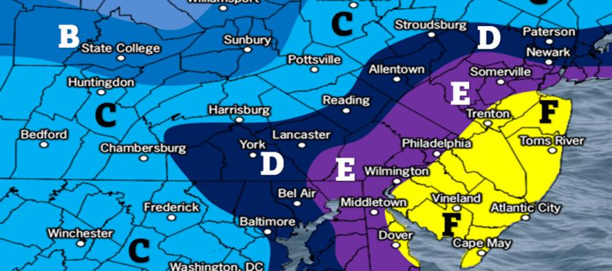
Snow Accumulation Map and Timing
The following is our first call snow map. As of right now, our timing is between noon Sunday and noon Monday. We expect snow to first break out between 6am and 10am Sunday morning in SNJ, spread into the rest of NJ by 3pm, snow hard 3pm to 8am, and then taper off around noon Monday. We expect the windy coastal component to crank hardest Sunday night into Monday morning during the peak of the nor’easter snowstorm in New Jersey.
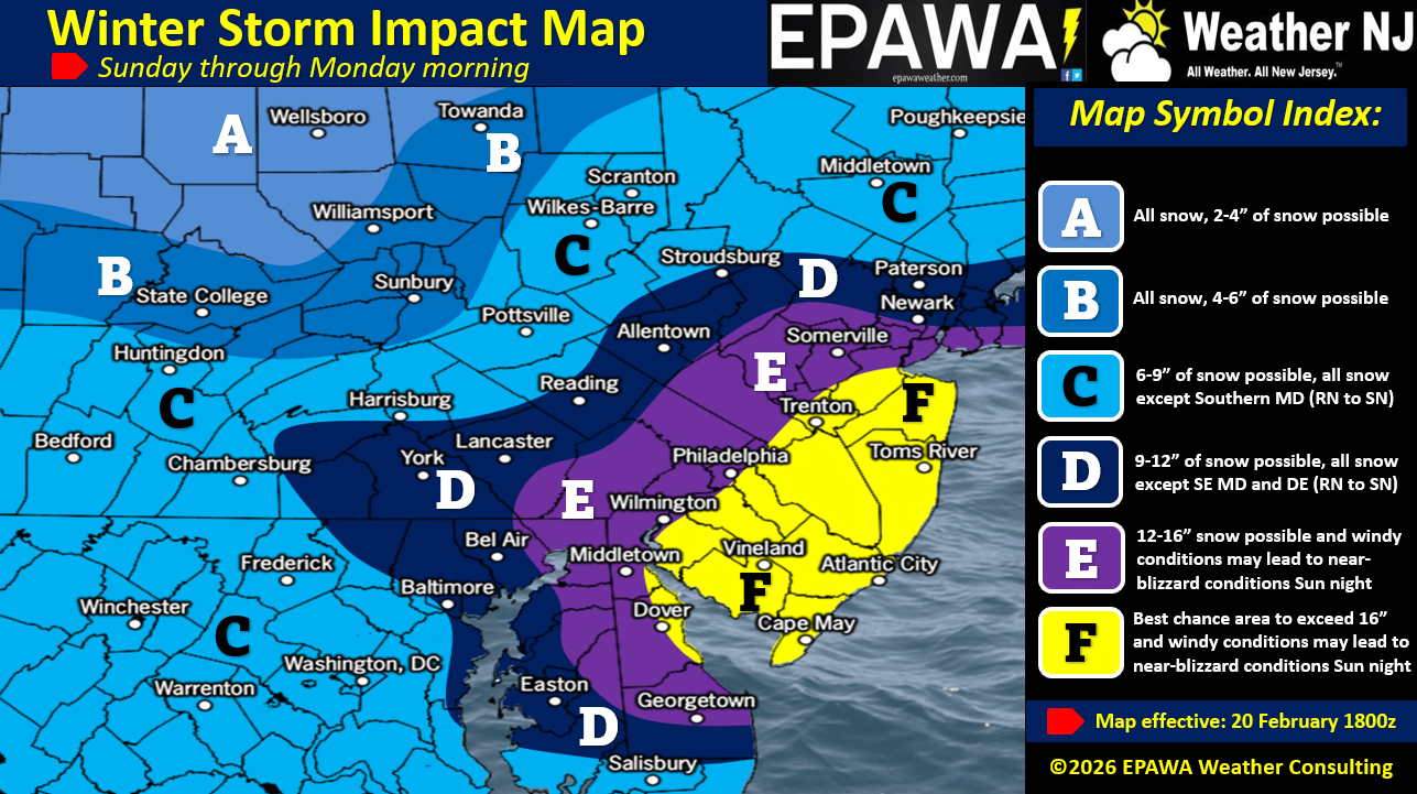
In English: Chances for a snowstorm Sunday into Monday continue to increase. The range of possibilities now seems like anything from a statewide KABOOM+ to only a ECNJ/SENJ KABOOM with the rest of NJ still seeing plowable/significant snowfall. Our map above represents the latest models today trending towards the original and persistent GFS solution (now 12 runs in a row). It’s our middle-of-the-road approach that leans heavy GFS. We expect light snow to first break out between 6am and 10am Sunday morning in SNJ, spread into the rest of NJ by 3pm while becoming moderate, snow heavy 3pm Sunday to 8am Monday, and then taper off around noon Monday or just after. There will be another YouTube video tonight. Be safe! JC
Premium Services
KABOOM Club offers an ad-free environment, inside info (Above and Beyond) forecast discussion, your questions prioritized, and early storm impact maps and video releases (ahead of the public). At $1.99 per month, it’s an extremely feasible way to show additional support for Weather NJ and you can turn it on and off for however many months you wish. Think of it as a tip jar with perks. Available onFacebook or Patreon.
My Pocket Meteorologist (MPM), in partnership with EPAWA Weather Consulting, offers professional/commercial interests, whose businesses depend on outdoor weather conditions (snow plowing, landscaping, construction, etc.), with hyper-local text message alerts/forecasts from real meteorologists and access to the MPM premium forum—the most comprehensive and technical forecast discussion available for PA and NJ commercial interests.
KABOOM Shop is live if you want some KABOOM or Weather NJ Merch!
Sign up for ZoneWatch Radar and get 10% off
Jonathan Carr (JC) is the founder and sole operator of Weather NJ, New Jersey’s largest independent weather reporting agency. Since 2010, Jonathan has provided weather safety discussion and forecasting services for New Jersey and surrounding areas through the web and social media. Originally branded as Severe NJ Weather (before 2014), Weather NJ is proud to bring you accurate and responsible forecast discussion ahead of high-stakes weather scenarios that impact this great garden state of ours. All Weather. All New Jersey.™ Be safe! JC


LOCAL FORECAST | INTERACTIVE RADAR | LATEST NJ WEATHER ALERTS | WEDDING FORECAST| PRIVACY POLICY
© Copyright 2026 Weather NJ LLC. All Rights Reserved.
Some information that can be found on our website is provided by a private weather station and is not an officially recognized station for weather reporting. Though we always strive to achieve accurate reporting for our own use, it is important that you do NOT depend on the data provided here for any purpose.
