

Major Snowfall Eyeing North Jersey
Discussion: A full-blown nor’easter could heavily impact most of New England, E NY State, NE PA, and NNJ pretty hard this Monday-Tuesday. We’re talking major interior snow accumulation, blizzard wind and visibility conditions, and coastal battering and flooding.
Tomorrow (Sunday) a ridge should flex in the W US as a northern stream shortwave forms an upper-low/trough and dips for the E US (over the lakes). On Monday, the upper-low energy will start to pull in another shortwave on a southern stream and tilt the trough negative. This phase will likely bomb-out a surface low expected to track from OBX to Cape Cod. The sfc low is then strongly modeled to stall near Cape Cod, retrograde, possibly loop, and resume its path to the NE. For these reasons, the above areas I mentioned are looking at a major winter storm.
There is likely going to be a very sharp cutoff somewhere between I-78 and I-80 where a lot of snow can go to zero snow in just a 20 mile (or less) distance from N to S. Everyone along and N of I-80 should see the jackpot snow accumulation (for NJ). Everyone S of I-78 are looking at mostly rain or a wintry mix possibly ending snowy but with little-to-no snow accumulation. Here’s a graphic of my current thoughts.
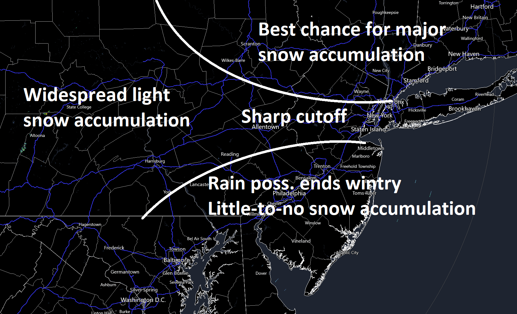
All of the mid-March anti-snow caveats are in play: higher sun angle, general climatology, marginal surface temperatures, etc. I don’t think the storm system will phase early enough to overcome these forces (snow hard enough) in CNJ and SNJ…only in NNJ. On the very backside of the storm system Tuesday, some snow could swing through CNJ/SNJ from N to S. But accumulation would be unlikely, especially on roads.
Luckily for New Jersey, the nor’easter will only be in infancy Monday-Tuesday regarding coastal impacts. It should be an absolute beast Tuesday-Wednesday for coastal New England/Gulf of Maine/etc. But for NJ, I would call it just routine run-of-mill coastal storm conditions…wind gusts to 40mph+ and minor-to-moderate coastal flooding.
In English: Rain should move into New Jersey from the SW between Monday morning and afternoon and continue falling into Monday night. Winds should pick up and rain should change to snow Monday night in extreme NNJ. The snow/rain line should push southward through Tuesday morning to somewhere between I-80 and I-78. The way things have gone this winter, probably closer to I-80. NNJ areas that do go over to snow by early Tuesday AM should see at least significant snow accumulations, possibly major. Areas below the snow/rain line (likely below I-78 or even I-80) should expect mostly rain with maybe some ending snow later Tuesday. Precipitation should end for all areas by Tuesday afternoon/evening. Expect windy conditions, especially along the coast with the chance for at least minor coastal flooding. Peak winds will probably flex between Monday night and Tuesday night. We’ll have a proper snow map tomorrow. Have a great Saturday evening and please be safe! JC
Premium Services
KABOOM Club offers inside info forecast discussion, your questions answered, and early storm impact maps (ahead of the public). At 99 cents per month, it’s an extremely feasible way to show support.
My Pocket Meteorologist (MPM), in partnership with EPAWA Weather Consulting, offers professional/commercial interests, whose businesses depend on outdoor weather conditions (snow plowing, landscaping, construction, etc.), with hyper-local text message alerts/forecasts and access to the MPM premium forum—the most comprehensive and technical forecast discussion available for PA and NJ.
Jonathan Carr (JC) is the founder and sole operator of Weather NJ, New Jersey’s largest independent weather reporting agency. Since 2010, Jonathan has provided weather safety discussion and forecasting services for New Jersey and surrounding areas through the web and social media. Originally branded as Severe NJ Weather (before 2014), Weather NJ is proud to bring you accurate and responsible forecast discussion ahead of high-stakes weather scenarios that impact this great garden state of ours. All Weather. All New Jersey.™ Be safe! JC


LOCAL FORECAST | INTERACTIVE RADAR | LATEST NJ WEATHER ALERTS | WEDDING FORECAST| PRIVACY POLICY
© Copyright 2026 Weather NJ LLC. All Rights Reserved.
Some information that can be found on our website is provided by a private weather station and is not an officially recognized station for weather reporting. Though we always strive to achieve accurate reporting for our own use, it is important that you do NOT depend on the data provided here for any purpose.
