

Major Winter Storm Hits New Jersey
Discussion: A major winter storm hit New Jersey yesterday and today (January 28-29, 2022).
While it was only a light-to-significant event for some NJ areas, it absolutely KABOOMED ECNJ/SENJ with a widespread 12-18 inch snowfall.
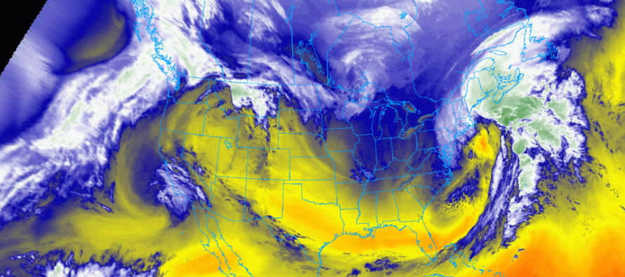
It started with a few pieces of upper-level energy off the polar and Pacific jets. The polar jet brought its energy in from central Canada and the pacific jet ran into W Canada. The northern stream energy dove over the N Plains US and the southern stream dove towards the Gulf of Mexico, bringing the sub-tropical jet into play. The two energy streams united in a cyclonic phase and closed off the upper levels from 850mb to 500mb. This turned the upper-level isobars (steering currents) into a S/SW to N’NE axis of heights for a coastal low to form off South Carolina and track up the coast…just SE of a 40N/70W benchmark track.
Decaying precipitation (pre-phase) from the N stream brought light snow across parts of PA and NJ yesterday as early as morning hours. The snow bands associated with the phase-guided coastal low (the main event) began producing light-to-moderate snow across NJ from about the turnpike/I-95 corridor and SE ward through the coast around 5pm. From there, precipitation slowly filled in and worked northward into NNJ and westward towards Philly. It wasn’t until about midnight that accumulating snow began for NNJ. Around midnight-1AM, a series of mesoscale convective bands began pushing into ECNJ/SENJ from the SE off the ocean. From about 1AM to 7AM these bands delivered most of the snowfall from the storm system. It’s been a slow taper from 7AM to now of on-and-off light-to-moderate snowfall, more concentrated in CNJ than in NNJ or SNJ. But we’re pretty much finished now aside from a few more snow showers clearing ENJ. It felt like the Arctic front was a little slower than expected which could, in theory, mean we lost some higher-ratio accumulation. But that’s getting pretty nit-picky.
The majority of our snow map and forecast verified (for about 90% of the state). Some parts of NNJ (especially NENJ) fell just short of the expected range. But everyone else, especially ECNJ/SENJ fell within range. Winds cranked as expected and coastal flooding was up there but manageable. The northerly wind direction helped with that. Overall I am happy with our (Weather NJ & EPAWA) research, observation, and forecasting associated with this major winter storm.
This storm marks the end of the favorable winter pattern that began just after the new year. The entire pattern favored SNJ/SENJ moreso than the rest of the state. The Jan 3 and Jan 7 events took Atlantic City to their annual average snow amount. And this storm just blew it over. The Jan 15 event dropped 6-8 across NNJ/CNJ before changing to rain. We had a -AO/-NAO but lacked a +PNA ridge (blocking) until the storm ending now. We’ll enter a less favorable pattern for winter storm development now but thread-the-needle events are always possible. I am casually watching Feb 4 and Feb 6 periods after the milder warmup mid-week.
In English: Tonight is going to be bitter cold in the NW wake winds of the departing large mid-latitude cyclone. Single digits and teens likely but with blistering winds making it feel even 10-15 degrees colder. Tomorrow (Sunday) the entire state should stay below freezing for high afternoon temperatures. Then we’ll moderate and become relatively mild by mid-week. This warmup was expected in the first week of February. We then have a few more longer-range storm signals to casually track for ~Feb 4 and ~Feb 6. The former looks warm (rain). The latter looks cold enough but needs work on upper-level energy timing. For now, stay warm for the rest of this weekend and get ready for some 40s/50s mid-week. Thank you all for the tremendous support. Have a great rest of your weekend and please be safe! JC
Cover image source (of GOES-East Lower Level Water Vapor Satellite Imagery): College of DuPage Nex Lab
Jonathan Carr (JC) is the founder and sole operator of Weather NJ, New Jersey’s largest independent weather reporting agency. Since 2010, Jonathan has provided weather safety discussion and forecasting services for New Jersey and surrounding areas through the web and social media. Originally branded as Severe NJ Weather (before 2014), Weather NJ is proud to bring you accurate and responsible forecast discussion ahead of high-stakes weather scenarios that impact this great garden state of ours. All Weather. All New Jersey.™ Be safe! JC


LOCAL FORECAST | INTERACTIVE RADAR | LATEST NJ WEATHER ALERTS | WEDDING FORECAST| PRIVACY POLICY
© Copyright 2026 Weather NJ LLC. All Rights Reserved.
Some information that can be found on our website is provided by a private weather station and is not an officially recognized station for weather reporting. Though we always strive to achieve accurate reporting for our own use, it is important that you do NOT depend on the data provided here for any purpose.
