

Major Winter Storm Possible
Discussion: The focus this week will be on the potential major winter storm this Saturday. Model guidance continues to trend towards a KABOOM storm system riding up the coast. But we’re not there yet. There’s still some time to continue casually monitoring the signal before jumping into serious storm tracking mode. If the guidance keeps the status quo through Tuesday night (tomorrow night), then I’ll be changing social media profile images Wednesday morning. If it drops off, it drops off and that’s life in the weather world.
If you’re here right now to know exactly how many inches of snow will fall in your backyard, you’re in the wrong place. Best to download a weather app and live-or-die by your daily weather prediction icon. I have to warn you though, those weather apps are fed by a single model and only interpret the surface. So they will change every 6 hours. If you want to most comprehensive analysis of multiple models, including upper-level dynamics and how they change the forecast icons on your app, then you are in the right place. Here you won’t find a static concrete prediction from this point but rather a responsible discussion of narrowing probabilities as we closer approach. Just want to re-emphasize this heading into this. With that said, let’s talk about Saturday.
The former signal for Tuesday (tomorrow) fell apart because the N stream and S stream will not interact enough to form a consolidated storm system. The S stream will fizzle out across the extreme SE US and only the N stream will pass nearby/just to N of NJ. The N stream weak surface low, that will pass through NY State from W to E tomorrow (Tuesday), will pull the Arctic air back down over NJ in it’s wake (backside cyclonic flow). I don’t need to tell you how cold that air mass is. We’ve been experiencing it on and off since early January. But this mechanism tomorrow will set the stage for a very cold Tuesday night through Friday morning in the Mid-Atlantic US including all of NJ. A cold setup ahead of the storm signal.
A blend of current model guidance is suggesting the following: Around Tuesday night/Wednesday morning, the energy associated with the Saturday signal will move off the Pacific Ocean onto W Canadian land. That energy should then dive towards Texas and emerge back over water (over the Gulf of Mexico) by Friday morning (just SW of Florida). It should then cross Florida as a weak surface wave of energy but then pop a stronger consolidated surface low in the W Atlantic Ocean off NC/SC by late Friday night. At this point we should see the mid-latitude cyclone formation approaching NJ from the S via radar/satellite obs. The surface low should then track northward along the east coast to the E of OBX and either just inside or right over the 40N/70W benchmark. At this point there will be a well-defined and deep trough over the E US correlating with a strong W US ridge. All of the front-side deep trough (PVA region) dynamics would create divergence and difluence for the surface low to bomb out (drop) it’s pressure from 1005mb+ to the 975-985mb range. This would then create a major snow event for NJ and much of the Mid-Atlantic/Northeast US.
What could go wrong? Because of the meridional nature of this surface low track, the system could cut W (bringing warmer marine air/rain to at least SENJ possibly more of NJ) or drift E and leave us with another fringe miss like this past Saturday (the storm that dumped on Virginia). The former and latter seem like realistic outer bounds for the range of possibilities. Our solution will likely be somewhere between.
Once that Saturday low is through and cleared out to the NE, another surge of Arctic air will drop into NJ behind (same principal as Tuesday’s N stream low in NY State) for a cold Saturday night through maybe Tuesday morning in NJ. February then looks to moderate in temperature for the first week. Don’t grab the bathing suits just yet though. It might not be Arctic air mass but still cold (highs in the 30s/40s…lows in the 20s/30s type stuff). Perhaps some interior spots hit 50. We’ll see. But at some point the cold will probably reload with more storm signals by mid-February. The current cold and active wintry pattern began with the Jan 3 SNJ KABOOM. We saw another event Jan 7 which hit mor of CNJ, the NNJ snow-to-rain system Jan 16, and the near miss Jan 22. This Saturday will likely be the end of the prolonged cold/active pattern. They tend to go out with a bang which is another reason I like this potential.
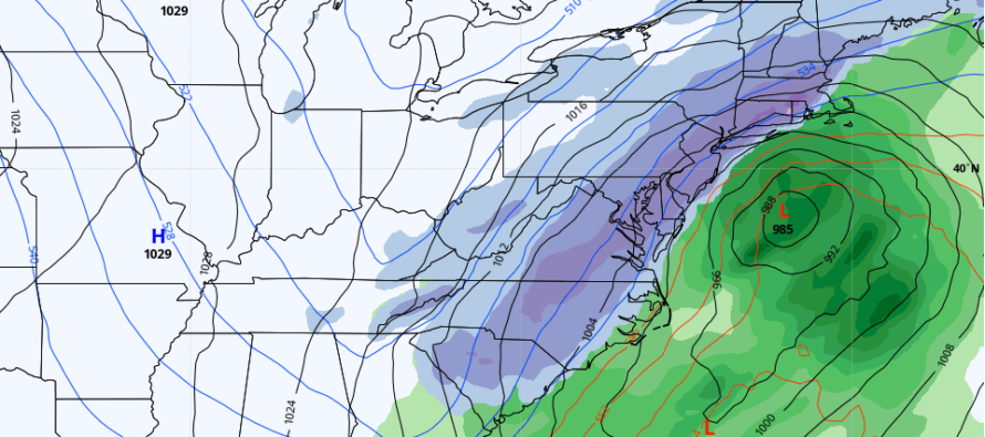
In English: Aside from some flurries and snow showers in NNJ, maybe CNJ, tonight through tomorrow, expect a cold and dry Tuesday night through Friday morning. A major winter storm (possibly a KABOOM) is then possible this Saturday. With the GFS, Canadian, and Euro all showing major hits on their latest runs, today and tomorrow are for confirmational monitoring. Image above is the GFS during peak 6 hours of event (precipitation type and intensity). Wednesday will start serious storm tracking if still showing on the model data and live obs. Pretty much don’t buckle up just yet but get ready to likely buckle up Wednesday. There will be daily articles heading in from this point. Be safe! JC
Download the free Weather NJ mobile app on Apple or Android. It’s the easiest way to never miss Weather NJ content. Our premium services go even further above and beyond at the hyper-local level.
Jonathan Carr (JC) is the founder and sole operator of Weather NJ, New Jersey’s largest independent weather reporting agency. Since 2010, Jonathan has provided weather safety discussion and forecasting services for New Jersey and surrounding areas through the web and social media. Originally branded as Severe NJ Weather (before 2014), Weather NJ is proud to bring you accurate and responsible forecast discussion ahead of high-stakes weather scenarios that impact this great garden state of ours. All Weather. All New Jersey.™ Be safe! JC


LOCAL FORECAST | INTERACTIVE RADAR | LATEST NJ WEATHER ALERTS | WEDDING FORECAST| PRIVACY POLICY
© Copyright 2025 Weather NJ LLC. All Rights Reserved.
Some information that can be found on our website is provided by a private weather station and is not an officially recognized station for weather reporting. Though we always strive to achieve accurate reporting for our own use, it is important that you do NOT depend on the data provided here for any purpose.
