

Mar 1: Snow Possible Friday
Light snow is possible on Friday. Let’s break it down…
Disco: After the cold front moves through tonight, NW winds will pick up and cool the entire region down for Thursday. By early Friday morning most of the state should be near or below-freezing. A northern stream clipper system will then quickly move through the region late-Friday morning (might last into early Friday afternoon) which could bring precipitation (both rain and wintry) across New Jersey.
I’m thinking this will mostly be conversational snowfall. While the upper-levels will be cold enough, the surface will struggle to stay below freezing for most. SNJ should easily reach into the 40s on Friday. NNJ might hover in the mid-30s. Therefore, I’m not expecting much accumulation from this quick-moving system. Any snowfall after 9AM will also be fighting the higher sun-angle of this time of year. It’s just not looking good for accumulations. Here’s the most significant model slide of the latest NAM (precip from 10AM-1PM):
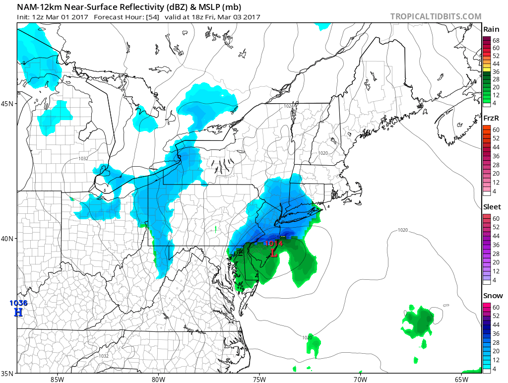
I suppose NNJ could eek out an inch or two in the higher elevations but that’s only if precipitation extent reaches that far N and is early enough (before sun gets too high). Lower points in NENJ and CNJ could see snowfall mix in with rain while SNJ likely deals with all rain. It should be out of here by noon on Friday (maybe by early afternoon) to set up a colder weekend.
In English: Light snow is possible Friday morning through early Friday afternoon however accumulations should be little-to-none. NWNJ elevations would have the best chance for stickage IF the snow makes it that far N in the system. NENJ/CNJ could see a wintry mix of snow and rain. SNJ will likely be too warm for snow. Although a few flakes might mix in, rain would be the most likely precip type for SNJ. Some higher elevations in PA might do okay since they will see this snowfall in pre-dawn hours. I’ll revisit this tomorrow night with the weekend outlook. For now, it’s looking like a conversational quick-moving light event. While traffic could get congested and dicey, it’s likely not a school closing event. Delays at most. Be safe! JC
Jonathan Carr (JC) is the founder and sole operator of Weather NJ, New Jersey’s largest independent weather reporting agency. Since 2010, Jonathan has provided weather safety discussion and forecasting services for New Jersey and surrounding areas through the web and social media. Originally branded as Severe NJ Weather (before 2014), Weather NJ is proud to bring you accurate and responsible forecast discussion ahead of high-stakes weather scenarios that impact this great garden state of ours. All Weather. All New Jersey.™ Be safe! JC


LOCAL FORECAST | INTERACTIVE RADAR | LATEST NJ WEATHER ALERTS | WEDDING FORECAST| PRIVACY POLICY
© Copyright 2026 Weather NJ LLC. All Rights Reserved.
Some information that can be found on our website is provided by a private weather station and is not an officially recognized station for weather reporting. Though we always strive to achieve accurate reporting for our own use, it is important that you do NOT depend on the data provided here for any purpose.
