

Mar 11: Winter Storm Expected
We’re about 48 hours away from from a coastal snow storm. Here are expected accumulations, general timing and coastal flooding concerns…
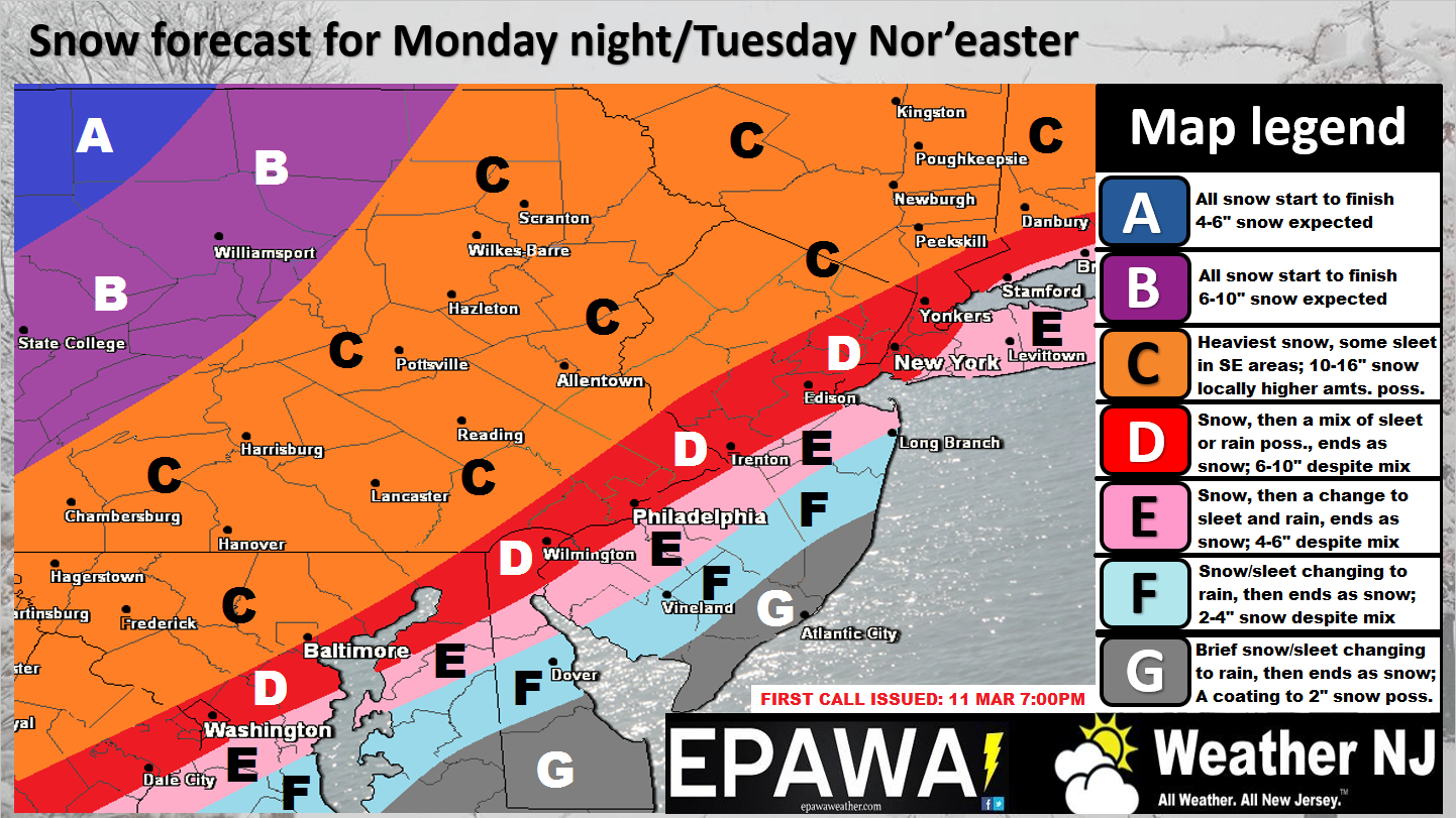
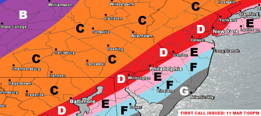
Follow this link for high-resolution version of winter storm impact map.
Disco: Our concerns for mixed precipitation types along and SE of the I-95 corridor haven’t gone anywhere. This trend is now well-established over the last 36 hours aside from the 12Z operational European run. We’re considering that run an outlier with the rationale that most 12Z European ensemble members (not to mention most other guidance) were W of the operational track.
We’re still seeing the northern and southern energy interact in a way that tilts the trough axis earlier. This allows the coastal surface low, associated with the southern stream energy, to race up the coast and tuck into the Mid-Atlantic US before pulling away to the NE. This brings wind and coastal flooding concerns to everyone along the Delaware Bay, Atlantic Ocean and Raritan Bay. We’re looking at a prolonged period of strong onshore flow between Monday night and Tuesday morning.
Tidal guidance is keying in on the late-morning high tide of Tuesday being the period to watch. We’re talking sustained winds of 30mph+ with gusts to 60mph possible along the coast. Those winds would in-theory push a decent amount of ocean water towards the shore. The saving grace is that this period of onshore flow should only last for about 12 hours which only targets the high tides of Monday night and Tuesday morning. At the very least, moderate coastal flooding and beach erosion is highly likely. These coastal areas of SENJ would likely deal with the most amount of rain mixed in and therefore are also areas that should expect lesser snow accumulations. As you head north on the Jersey coast, accumulation chances increase heading into the NYC area.
For everyone in New Jersey NW of the I-95 corridor (and well into PA/NY State), we currently believe this is your snow storm. The jackpot axis has been strongly and consistently modeled for this area and it makes the most climatological sense. If you notice, we aren’t really talking historic accumulations but certainly into the major category. This will be a heavy and wet low liquid-ratio snowfall for many.
Given the phasing dynamics and complexity of timing however, there are wildcards possible. I’ll make better note of these wildcards in more detail for tomorrow’s update. We’ll make adjustments as needed but the above image currently represents our most rational and evidence-based forecast.
In English: Draw a line right along the I-95 corridor from DC to Boston. To the NW of this line, chances of a disruptive and possibly major snow storm are increasing. This area therefore has the best chance to Kaboom. To the SE of this line, you might be looking at a snow to rain to snow type deal. Those right along that line could go either way. By tomorrow night’s update we should have a better handle on where the snow/rain line will push in to before pulling back out with all areas ending as snow. Right now there is tremendous uncertainty to that aspect of the storm. The general timing for this system is emerging as Monday evening through most of Tuesday. Strong onshore winds are expected later Monday night through Tuesday afternoon. Within that period are 2 high tides. The late-morning high tide on Tuesday should feature the highest tidal water levels of the system. The last thing I would like to mention is that heavy wet snow will be falling in many areas of higher winds. Therefore power outages are possible from downed wires, branches, trees, etc. It’s a good time to start securing your loose stuff. The above snow map represents our best current thoughts and we’ll adjust as needed tomorrow with a final call on Monday before the storm begins. Everyone have a great night and please be safe! JC
Jonathan Carr (JC) is the founder and sole operator of Weather NJ, New Jersey’s largest independent weather reporting agency. Since 2010, Jonathan has provided weather safety discussion and forecasting services for New Jersey and surrounding areas through the web and social media. Originally branded as Severe NJ Weather (before 2014), Weather NJ is proud to bring you accurate and responsible forecast discussion ahead of high-stakes weather scenarios that impact this great garden state of ours. All Weather. All New Jersey.™ Be safe! JC


LOCAL FORECAST | INTERACTIVE RADAR | LATEST NJ WEATHER ALERTS | WEDDING FORECAST| PRIVACY POLICY
© Copyright 2026 Weather NJ LLC. All Rights Reserved.
Some information that can be found on our website is provided by a private weather station and is not an officially recognized station for weather reporting. Though we always strive to achieve accurate reporting for our own use, it is important that you do NOT depend on the data provided here for any purpose.
